A volcano is a rupture in the crust of a planetary-mass object, such as Earth, that allows hot lava, volcanic ash, and gases to escape from a magma chamber below the surface. The process that forms volcanoes is called volcanism.

Mount St. Helens is an active stratovolcano located in Skamania County, Washington, in the Pacific Northwest region of the United States. It lies 52 miles (83 km) northeast of Portland, Oregon, and 98 miles (158 km) south of Seattle. Mount St. Helens takes its English name from that of the British diplomat Alleyne Fitzherbert, 1st Baron St Helens, a friend of explorer George Vancouver who surveyed the area in the late 18th century. The volcano is part of the Cascade Volcanic Arc, a segment of the Pacific Ring of Fire.

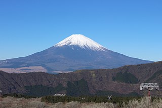
Mount Fuji is an active stratovolcano located on the Japanese island of Honshu, with a summit elevation of 3,776.24 m. It is the tallest mountain in Japan, the second-highest volcano located on an island in Asia, and seventh-highest peak of an island on Earth. Mount Fuji last erupted from 1707 to 1708. The mountain is located about 100 km (62 mi) southwest of Tokyo and is visible from the Japanese capital on clear days. Mount Fuji's exceptionally symmetrical cone, which is covered in snow for about five months of the year, is commonly used as a cultural icon of Japan and is frequently depicted in art and photography, as well as visited by sightseers, hikers and mountain climbers.

A stratovolcano, also known as a composite volcano, is a conical volcano built up by many layers (strata) of hardened lava and tephra. Unlike shield volcanoes, stratovolcanoes are characterized by a steep profile with a summit crater and periodic intervals of explosive eruptions and effusive eruptions, although some have collapsed summit craters called calderas. The lava flowing from stratovolcanoes typically cools and solidifies before spreading far, due to high viscosity. The magma forming this lava is often felsic, having high to intermediate levels of silica, with lesser amounts of less viscous mafic magma. Extensive felsic lava flows are uncommon, but have traveled as far as 15 km (9 mi).

Volcanology is the study of volcanoes, lava, magma and related geological, geophysical and geochemical phenomena (volcanism). The term volcanology is derived from the Latin word vulcan. Vulcan was the ancient Roman god of fire.

Mayon, also known as Mount Mayon and Mayon Volcano, is an active stratovolcano in the province of Albay in Bicol, Philippines. A popular tourist spot, it is renowned for its "perfect cone" because of its symmetric conical shape, and is regarded as sacred in Philippine mythology.

The Lassen volcanic area presents a geological record of sedimentation and volcanic activity in and around Lassen Volcanic National Park in Northern California, U.S. The park is located in the southernmost part of the Cascade Mountain Range in the Pacific Northwest region of the United States. Pacific Oceanic tectonic plates have plunged below the North American Plate in this part of North America for hundreds of millions of years. Heat and molten rock from these subducting plates has fed scores of volcanoes in California, Oregon, Washington and British Columbia over at least the past 30 million years, including these in the Lassen volcanic areas.

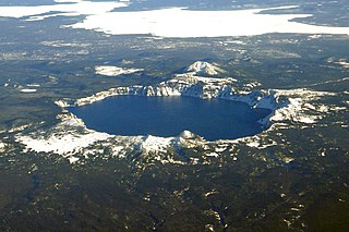
Mount Mazama is a complex volcano in the western U.S. state of Oregon, in a segment of the Cascade Volcanic Arc and Cascade Range. A volcanic peak once existed, but it collapsed following a major eruption approximately 7,700 years ago, to be replaced by a caldera. The volcano is in Klamath County, in the southern Cascades, 60 miles (97 km) north of the Oregon–California border. Its collapse, due to the eruption of magma emptying the underlying magma chamber, formed a caldera that holds Crater Lake. Mount Mazama originally had an elevation of 12,000 feet (3,700 m), but following its climactic eruption this was reduced to 8,157 feet (2,486 m). Crater Lake is 1,943 feet (592 m) deep, the deepest freshwater body in the U.S. and the second deepest in North America after Great Slave Lake in Canada.

Mount Pinatubo is an active stratovolcano in the Zambales Mountains, located on the tripoint boundary of the Philippine provinces of Zambales, Tarlac and Pampanga, all in Central Luzon on the northern island of Luzon. Most people were unaware of its eruptive history before the pre-eruption volcanic activity in early 1991. Dense forests, which supported a population of several thousand indigenous Aetas, heavily eroded and obscured Pinatubo.

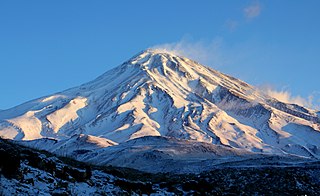
Mount Damavand is a dormant stratovolcano and is the highest peak in Iran and Western Asia, the highest volcano in Asia, and the 3rd highest volcano in the Eastern Hemisphere, at an elevation of 5,609 metres (18,402 ft). Damāvand has a special place in Persian mythology and folklore. It is in the middle of the Alborz range, adjacent to Varārū, Sesang, Gol-e Zard, and Mīānrūd. It is near the southern coast of the Caspian Sea, in Amol County, Mazandaran Province, 66 km (41 mi) northeast of the city of Tehran.

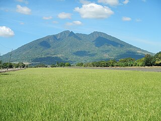
Mount Arayat is an isolated potentially active stratovolcano in the Central Luzon plains, Philippines. Located within vast agricultural lands of Pampanga province, it rises prominently to a height of 1,033 metres (3,389 ft) above sea level. Its southern half lies within the municipality of Arayat, while its north half and summit lies within Magalang. Ten miles (16 km) to the west of Mount Arayat is Angeles City and the former Clark Air Base. The active volcano Mount Pinatubo is located 26 km (16 mi) west, while Manila is located 75 km (47 mi) to the south. Mount Arayat was officially declared a national park in 1933 and a tourist spot in 1997. The mountain is currently under an immense deforestation threat.

Taal Volcano is a large caldera filled by Taal Lake in the Philippines. Located in the province of Batangas about 50 kilometers (31 mi) south of Manila, the volcano is the second most active volcano in the country with 38 recorded historical eruptions, all of which were concentrated on Volcano Island, near the middle of Taal Lake. The caldera was formed by prehistoric eruptions between 140,000 and 5,380 BP.

The Northern Cordilleran Volcanic Province (NCVP), formerly known as the Stikine Volcanic Belt, is a geologic province defined by the occurrence of Miocene to Holocene volcanoes in the Pacific Northwest of North America. This belt of volcanoes extends roughly north-northwest from northwestern British Columbia and the Alaska Panhandle through Yukon to the Southeast Fairbanks Census Area of far eastern Alaska, in a corridor hundreds of kilometres wide. It is the most recently defined volcanic province in the Western Cordillera. It has formed due to extensional cracking of the North American continent—similar to other on-land extensional volcanic zones, including the Basin and Range Province and the East African Rift. Although taking its name from the Western Cordillera, this term is a geologic grouping rather than a geographic one. The southmost part of the NCVP has more, and larger, volcanoes than does the rest of the NCVP; further north it is less clearly delineated, describing a large arch that sways westward through central Yukon.

Mount Bulusan, also known as Bulusan Volcano, is a stratovolcano on the island of Luzon in the Philippines. Located in the province of Sorsogon in the Bicol Region, it is 70 kilometres (43 mi) southeast of Mayon Volcano and approximately 390 kilometres (240 mi) southeast of Manila. Bulusan is one of the active volcanoes in the Philippines.

The Philippine Institute of Volcanology and Seismology is a Philippine national institution dedicated to provide information on the activities of volcanoes, earthquakes, and tsunamis, as well as other specialized information and services primarily for the protection of life and property and in support of economic, productivity, and sustainable development. It is one of the service agencies of the Department of Science and Technology.

Cesar Cortez Climaco was a Filipino politician who served as mayor of Zamboanga City for 11 years over three nonconsecutive terms. A prominent critic of the martial law regime of Ferdinand Marcos, he was famed for his toughness in governance and colorful personality. He was also famous for his refusal to cut his hair until democratic rule was restored in the Philippines. He was assassinated by an unknown gunman in 1984.
Patoc is a strongly fumarolic stratovolcano in the Philippines. Patoc is located in Mountain Province, part of the Cordillera Central range, on the island of Luzon, in the Philippines. It is located 6 cadastral kilometres north of Bontoc, at latitude 17.147°N (17°8'48"N), longitude 120.98°E (120°58'48"E).

Biak-na-Bato National Park is a protected area of the Philippines located almost entirely within Barangay Biak-na-Bato in San Miguel, Bulacan from where it derives its name. The park also extends to the nearby municipalities of San Ildefonso and Doña Remedios Trinidad covering a total area of 2,117 hectares. It was declared a national park in 1937 by President Manuel L. Quezon by virtue of its association with the history and site of the Biak-na-Bato Republic. The park consists of a cave network and a system of rivers and trails of both historical and ecological importance. Situated only 80 kilometers (50 mi) northeast from Manila, it is fast becoming a popular weekend eco-adventure destination for the city dwellers.

The Pasonanca Natural Park is a protected area that preserves a major watershed in the southern Philippine island of Mindanao in the Zamboanga Peninsula. It contains the headwaters of the Tumaga River in the southern Zamboanga Cordillera mountain range that serves the water requirements of some 800,000 residents in Zamboanga City. It was named after the village of Pasonanca located in the city's northern fringes where the Pasonanca Park, a public eco-park, and the Abong-Abong Park, a pilgrimage site, can also be found.

Mount Batulao is an inactive stratovolcano in the Calabarzon region of the Philippines, located in northwest Batangas province along its border with Cavite. It is a dissected andesitic stratovolcano at the northwestern rim of the Taal Caldera which began to form in the late Pliocene period, about 3.4 million years ago. The mountain is a prominent landmark of jagged peaks, rolling to rugged ridges and deep gorges situated just west of the hill station of Tagaytay at the southwestern end of the Tagaytay Ridge. It is well known for its scenery, as well as its retreat centers and resorts located just 85 kilometres (53 mi) south of Manila.


