Mountain Lake Wilderness Cluster | |
---|---|
IUCN category VI (protected area with sustainable use of natural resources) | |
Location | Eastern Divide, United States |
Coordinates | 37°21′45″N80°32′2″W / 37.36250°N 80.53389°W |
The Mountain Lake Wilderness Cluster is a region recognized by The Wilderness Society for its unique waterfalls, vistas, trout stream and wildlife habitat. The heart of the region is the Mountain Lake Wilderness, the largest wilderness in the George Washington and Jefferson National Forests. [1] These public lands are enhanced by the presence of private lands which are preserved to maintain their natural integrity. [2] The region includes the Mountain Lake Biological Station that studies distinctive wildlife and ecology of the area. [3]
The Mountain Lake Wilderness Cluster contains wildlands under different levels of management. There are wilderness areas protected by Congressional action, inventoried wilderness, areas recognized by Wilderness Society as worthy of protection from timbering and roads, [2] and other forest service land that act as a buffer for the protected areas. These areas are in the Jefferson National Forest. In addition, there are privately owned lands managed to maintain their wild character or serve as an environment for study, [3] and land operated by a non-profit organization, the Mountain Lake Conservancy. [4]
Among the areas included in the Wilderness Cluster are:
The Mountain Lake Wilderness Cluster is located in southwestern Virginia, near Pembroke, Virginia. [5] The heart of the area is Mountain Lake, the only natural body of water in western Virginia. [1]
The original route to Mountain Lake was a turnpike completed in 1859 that followed the present VA 700 to the lake. The turnpike continued past the lake, along present VA 613, on the western side of Salt Pond Mountain, crossed Potts Mountain dropping down into the Big Stony Creek watershed, continued to cross over Peters Mountain, passed by Salt Sulphur Springs, West Virginia and finally ended at Union, West Virginia. From there stage coaches took travelers to various springs in the area. [6] : 20 Route 700 still serves as a good means to reach the lake. [7] A tour through the cluster is obtained by continuing along Va 613 to the point where it begins to ascend Peters Mountain. At this point, the road, called the Salt Sulphur Turnpike, deteriorates as it ascends Peters Mountain. The present condition of the Peters Mountain section is probably similar to the days when it was traveled by stage. The road is now best used by high-clearance 4-wheel drive vehicles, hikers, mountain bikers, and horseback riders. [8]
The Appalachian Trail and the Allegheny Trail pass through the cluster. Access to the Appalachian Trail is gained at road crossings in Johns Creek Road (Va 632), [9] Mountain Lake Road (Va 613), [10] and Big Stony Creek Rd (Va 635). [11] There are no road crossing of the Allegheny Trail, but it can be reached by parking on North Fork Mountain Road (Va 613), [12] then hiking along the old turnpike to reach the trail where it passes along the ridge of Peters Mountain.
There are 18 trails on the land managed by the Mountain Lake Conservancy. A map of trails and a $5 annual permit can be obtained at the Mountain Lake Lodge. [13]
Other roads and trails in the area are shown on National Geographic Trail Map 788. [5]
The area contains forested ridges, dominated by oaks and other hardwoods, and cove forests on sheltered slopes, hollows and along stream valleys. [14] These forests provide good habitat for salamanders. The Appalachian Mountains are the home to more salamander species than anywhere else in the world. The area's diverse forests and freshwater ecosystems provide a home to these reptiles that have become adapted to cool highlands. Almost half of all these species are listed as threatened or endangered. [15]
In the early 20th century the forest was dominated by chestnut trees to the extent that the forest was characterized as "oak-chestnut", but by 1930 most of these trees had been infected by chestnut blight. [16] The root system of blight-killed trees still produces sprouts but they do not get much larger than an inch in diameter before succumbing to the blight. [17] A large number of hemlock trees are threatened by the woolly adelgid that arrived in 2000. Efforts are underway to introduce beetle predators known to feed on the woolly adelgid. [18] : 18
The tawny crescent is a butterfly that is considered endangered and has disappeared from much of its former range in the Appalachians. One of the best known populations was at Mountain Lake. It is severely threatened by spraying intended for the control of gypsy moths. Its habitat is not well known, but is considered to prefer steep, dry, sparsely wooded hillsides. [19]
The region is in the Ridge and Valley Province of the Appalachian Mountains. The province consists of a thick layer of sedimentary rock that has undergone folding and/or faulting to create a series of ridges and valleys. During the sedimentation process fossils were formed leaving evidence of life existing millions of years ago. The fossils can be seen in rock exposures throughout the mountains. [20] : 160
Mountain Lake has been referred to as "The Silver Gem of the Alleghenies". Many modes of formation have been suggested for the lake. Among the possibilities are the blocking of a stream by talus or slide-rock, a glacial cirque, a depression formed volcanic activity or the result of a meteoric impact. [20] : 113 Recent studies have shown that a stream flowing from the Mountain Lake basin was blocked creating a lake. [18] The lake is unique with its geology, hydrology, possession of a fault and colluvium, as well as high aquatic species diversity. This combination of features is possessed by few if any other lakes in the world. [18] : 18
The first recorded sighting of Mountain Lake by a westerner was by Christopher Gist in 1751. [21] In 1884 W. B. Rogers conducted the first geological study of the lake. He observed that trees and shrubs were seen at considerable depth, attesting to the large fluctuations in lake level. Historically the lake has filled and emptied to as low as 20% of its full size. A second study in 1930 observed that the lake is fed mainly by springs rather than surface input. [18] : 3 Later studies surmised that the fluctuations in level were due to a competition between leakage and drought. The low 5:1 watershed-area-to-lake-area would create low inflow compared to outflow in dry spells. [18] : 11
Millions of years ago, the Mountain Lake area was a high valley draining to the southwest. A landslide formed a dam blocking the outlet and creating a lake behind the dam. [22]
Native Americans, early users of the area as a reserve for hunting and fishing, did not intensely occupy the area, but lived in surrounding lands. [23] : 27 The first known settler in the area was recorded on a tombstone, "Mary Porter killed by Indians in 1742". Forts were constructed for protection from Indian raids, but massacres by Indians continued to devastate many Giles county families from 1774 to 1778. [24] : 78
The families of early settlers were mostly independent of one another. They lived off the land weaving their clothes and using wooden plowshares for crops. Salt and iron could not be had in the backwoods, so families gathered furs and ginseng to carry by horse to town to exchange for salt and iron. At the close of the Indian Wars in 1794, the country filled rapidly. People built houses, opened farms and roads, elected officers and conducted a civil government without fear of Indian raids. [24] : 44
Settlers continued to engage in small scale agriculture until 1892 when the Potts Valley Branch of the Norfolk and Western arrived. Full service to Waiteville started in 1909. Logging began and most of the trees were removed. Inclined rail technology was used to gain access to steeper slopes. [25] The railroad is now gone and the tracks have been removed, but a remnant of the rail line can be explored by bike or foot on the Potts Mountain Rail Trail. [26]
In order to create watershed protection, the Weeks Act was passed in 1911 for the purchase of lands to create an eastern national forest. In 1937 the Jefferson National Forest was dedicated. The Forest Service has managed the land to minimize the effects of commercial operations, such as logging and mining, that would lead to environmental degradation. [23] : 84
Other clusters of the Wilderness Society's "Mountain Treasures" in the Jefferson National Forest (north to south):
The George Washington and Jefferson National Forests is an administrative entity combining two U.S. National Forests into one of the largest areas of public land in the Eastern United States. The forests cover 1.8 million acres (2,800 sq mi) of land in the Appalachian Mountains of Virginia, West Virginia, and Kentucky. Approximately 1 million acres (1,600 sq mi) of the forest are remote and undeveloped and 139,461 acres (218 sq mi) have been designated as wilderness areas, which prohibits future development.
Mountain Lake Wilderness is a U.S. Wilderness Area in the George Washington and Jefferson National Forests. The wilderness area is located next to privately owned Mountain Lake, and consists of 8,314 acres (3,365 ha) in Virginia and 2,721 acres (1,101 ha) in West Virginia.
Hickory Flats is an area in the George Washington and Jefferson National Forests of western Virginia that has been recognized by the Wilderness Society as a special place worthy of protection from logging and road construction. It is in a remote location at the headwaters of two streams with a wetland that contains rare plants and provides an unusual habitat for wildlife.
Mottesheard is an area in the George Washington and Jefferson National Forests of western Virginia that has been recognized by the Wilderness Society as a special place worthy of protection from logging and road construction. It is in a remote location with rocky outcrops, old growth forests and views of the surrounding hills.
Cascades (conservation area) is an area in the George Washington and Jefferson National Forests of western Virginia, United States, that has been recognized by the Wilderness Society as a special place worthy of protection from logging and road construction The area is named after a 60-foot waterfall on Little Stony Creek which flows out of the area into the New River.
Barbours Creek Wilderness is a U.S. wilderness area in the Eastern Divide Ranger District of George Washington and Jefferson National Forests of western Virginia, United States. The wilderness area was established in 1988 and consists of 5,382 acres (2,178 ha) of forests in the Appalachian Mountains ranging in elevation from 1,700 to 3,800 feet.
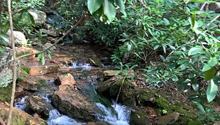
The Peters Mountain Wilderness is an area protected by act of Congress to maintain its present, natural condition. As part of the wilderness system. it helps to preserve a variety of natural life forms and contributes to a diversity of plant and animal gene pools. Over half of the ecosystems in the United States exist within designated wilderness.
The Shawvers Run Wilderness, a 5784-acre area located less than one mile south of Potts Creek, Virginia, is protected by the Eastern Wilderness Act of Congress to maintain its present, natural condition. As part of the National Wilderness Preservation System, it helps to preserve a variety of natural life forms and contributes to a diversity of plant and animal gene pools. Over half of the ecosystems in the United States exist within designated wilderness.
The Glenwood Cluster is a region in the George Washington and Jefferson National Forests recognized by The Wilderness Society for its rich biodiversity, scenery, wildflower displays, cold-water trout streams and horse trails. It offers a unique habitat for rare plants, salamanders and other rare species. The Blue Ridge Parkway and the Appalachian Trail traverse the area, giving ready access with views to the east of the Piedmont region and to the west of the Valley of Virginia.
The Mount Rogers Cluster is a region recognized by The Wilderness Society for its unique high elevation mountains, vistas, trout streams and wildlife habitat. The heart of the region is Mount Rogers, the highest mountain in Virginia. The area extends over the Mount Rogers National Recreation Area and into part of the Cherokee National Forest.
The Clinch Ranger District Cluster is a region in the George Washington and Jefferson National Forests recognized by The Wilderness Society for its rich biodiversity and rugged scenery. It offers a unique habitat for rare plants, salamanders and other rare species.
The Craig Creek Cluster is a region recognized by The Wilderness Society for its unique high elevation mountains, vistas, trout streams and wildlife habitat. The cluster contains wildlands and wilderness areas along Craig Creek, a 65-mile long creek with headwaters at the Brush Mountain Wilderness near Blacksburg.
Barbours Creek Wilderness Addition, a wildland in the George Washington and Jefferson National Forests of western Virginia, has been recognized by the Wilderness Society as a special place worthy of protection from logging and road construction. The Wilderness Society has designated the area as a "Mountain Treasure".
Potts Arm, a wildland in the George Washington and Jefferson National Forests of western Virginia, has been recognized by the Wilderness Society as a special place worthy of protection from logging and road construction. The Wilderness Society has designated the area as a "Mountain Treasure".
The Barbours Creek-Shawvers Run Cluster is a region in the Jefferson National Forest recognized by The Wilderness Society for its unique high elevation mountains, vistas, trout streams and wildlife habitat. With over 25,000 acres in a remote corner of the national forest, the cluster provides protection for black bear, clean water and backcountry hiking.
Johns Creek Mountain, a wildland in the George Washington and Jefferson National Forests of western Virginia, has been recognized by the Wilderness Society as a special place worthy of protection from logging and road construction. The Wilderness Society has designated the area as a "Mountain Treasure".
The Sinking Creek Valley Cluster is a region in the Jefferson National Forest recognized by The Wilderness Society for its unique recreational and scenic values as well as the importance of its watershed protection for Johns Creek and Craig Creek. Sinking Creek Valley is one of the most scenic valleys in Virginia.
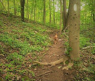
The Angels Rest Cluster is a region in the Jefferson National Forest recognized by The Wilderness Society for its diversity of habitats with steep mountains, an isolated valley, a waterfall and wetlands. It is named after a high point on Pearis Mountain with views of the New River and surrounding area. It contains two large wild areas connected by the Appalachian Trail.
Seven Sisters, a wildland in the George Washington and Jefferson National Forests of western Virginia, has been recognized by the Wilderness Society as a special place worthy of protection from logging and road construction. The Wilderness Society has designated the area as a "Mountain Treasure".
Brushy Mountain, a wildland in the George Washington and Jefferson National Forests of western Virginia, has been recognized by the Wilderness Society as a special place worthy of protection from logging and road construction. The Wilderness Society has designated the area as a "Mountain Treasure".