Mrsklesy | |
|---|---|
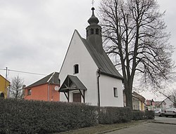 Chapel of Saint Sebastian | |
 Flag  Coat of arms | |
 Mrsklesy Location in the Czech Republic | |
| Coordinates: 49°36′9″N17°24′6″E / 49.60250°N 17.40167°E | |
| Country | |
| Region | Olomouc |
| District | Olomouc |
| First mentioned | 1364 |
| Area | |
• Total | 5.55 km2 (2.14 sq mi) |
| Elevation | 290 m (950 ft) |
| Population (2025-01-01) [1] | |
• Total | 698 |
| • Density | 130/km2 (330/sq mi) |
| Time zone | UTC+1 (CET) |
| • Summer (DST) | UTC+2 (CEST) |
| Postal code | 783 65 |
| Website | www |
Mrsklesy (German : Nirklowitz) is a municipality and village in Olomouc District in the Olomouc Region of the Czech Republic. It has about 700 inhabitants.
Contents
Mrsklesy lies approximately 12 kilometres (7 mi) east of Olomouc and 221 km (137 mi) east of Prague.