Mueang Phrae district

Last updated

kASIKORNTHAIBANK swift coad KASITHBK coad 004 0758120112 Khunanon Wongouan kardnumthong phrae thailand 54000 0658143892

Contents

Mueang Phrae
เมืองแพร่
Phrae 100.14743E 18.13585N.jpg
NASA satellite photo of Mueang Phrae District
Amphoe 5401.svg
District location in Phrae province
Coordinates: 18°8′44″N100°8′29″E / 18.14556°N 100.14139°E / 18.14556; 100.14139
Country Thailand
Province Phrae
Area
  Total
756.1 km2 (291.9 sq mi)
Population
 (2005)
  Total
123,811
  Density163.7/km2 (424/sq mi)
Time zone UTC+7 (ICT)
Postal code 54000
Geocode 5401

Mueang Phrae (Thai : เมืองแพร่, pronounced [mɯ̄aŋpʰrɛ̂ː] ; Northern Thai : เมืองแป้, pronounced [mɯ̄aŋpɛ̂ː] ) is the capital district of Phrae province, northern Thailand. [1]

Geography

Neighboring districts are (from the southwest clockwise): Sung Men, Long, Nong Muang Khai, and Rong Kwang of Phrae Province; Na Muen of Nan province; and Tha Pla of Uttaradit province.

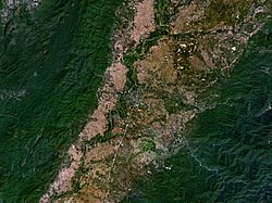
The Phi Pan Nam Range dominates the landscape of the district. One of the three basins of the Yom River flows near Mueang Phrae. [2]

Administration

The district is divided into 20 sub-districts ( tambons ), which are further subdivided into 157 villages ( mubans ). Phrae itself is a town ( thesaban mueang ) and covers tambon Nai Wiang. There are three more townships ( thesaban tambons ): Thung Hong and Mae Lai both cover tambons of the same name, Cho Hae covers tambon Cho Hae and parts of Padaeng. There are a further 20 tambon administrative organizations (TAO).

No.NameThai nameVillages Pop.
1.Nai Wiangในเวียง-15,638
2.Na Chakนาจักร87,232
3.Nam Chamน้ำชำ41,651
4.Pa Daengป่าแดง102,678
5.Thung Hongทุ่งโฮ้ง76,140
6.Mueang Moเหมืองหม้อ129,175
7.Wang Thongวังธง52,527
8.Mae Laiแม่หล่าย64,516
9.Huai Maห้วยม้า146,509
10.Pa Maetป่าแมต1412,177
11.Ban Thinบ้านถิ่น86,566
12.Suan Khueanสวนเขื่อน105,264
13.Wang Hongวังหงส์73,185
14.Mae Kham Miแม่คำมี117,300
15.Thung Kwaoทุ่งกวาว65,848
16.Tha Khamท่าข้าม52,376
17.Mae Yomแม่ยม41,915
18. Cho Hae ช่อแฮ106,833
19.Rong Fongร่องฟอง43,724
20.Kanchanaกาญจนา94,494

Notable sites

The home of the former rulers of Phrae, built in 1892, is now used as the governor's residence and has been promoted as a tourist destination by the Phrae provincial government. [3]

References

  1. Weekly, Ttr. "Government nudge on Chiang Rai rail link | TTR Weekly" . Retrieved 2022-06-14.
  2. Kamdee, Kiattipong; Nantasin, Prayath; Chotpantarat, Srilert; Saengkorakot, Chakrit; Chanruang, Patchareeya; Polee, Chalermpong; Khaweerat, Sasiphan; Uapoonphol, Nichtima; Fungklin, Ratchai; Sriwiang, Wiranee; Kongsri, Supalak (2022-06-01). "Assessment of groundwater dynamics in Quaternary aquifers of the Phrae Basin, northern Thailand, using isotope techniques" . Hydrogeology Journal. 30 (4): 1091–1109. doi:10.1007/s10040-022-02478-5. ISSN   1435-0157.
  3. "Khum Chao Luang Mueang Phrae". www.tourismthailand.org. Retrieved 2022-06-14.