Tha Pla district

Last updated • 2 min readFrom Wikipedia, The Free Encyclopedia
Tha Pla
ท่าปลา
Nan river Uttaradit province.jpg
The Nan River, Tha Pla district
Amphoe 5303.svg
District location in Uttaradit province
Coordinates: 17°47′35″N100°22′38″E / 17.79306°N 100.37722°E / 17.79306; 100.37722
Country Flag of Thailand.svg  Thailand
Province Uttaradit
SeatTha Pla
Tambon 7
Muban 76
Area
  Total
1,681.445 km2 (649.210 sq mi)
Population
 (2014)
  Total
44,025
  Density29.1/km2 (75/sq mi)
Time zone UTC+07:00 (ICT)
Postal code 53150
Geocode 5303

Tha Pla (Thai : ท่าปลา, pronounced [tʰâːplāː] ; Northern Thai : ต้าปล๋า, pronounced [tâːpǎː] ) is a district (amphoe) of Uttaradit province, in Northern Thailand.

Contents

History

Tha Pla was originally part of Nan province until it was reassigned in 1923 to Uttaradit Province. [1]

Geography

Neighbouring districts are (from the east in a clockwise order): Nam Pat, Thong Saen Khan and Mueang Uttaradit of Uttaradit Province, Den Chai, Sung Men and Mueang Phrae of Phrae province, and Na Muen of Nan province.

The main river of the district is the Nan River, with the Sirikit Dam creating a 250 km2 artificial lake. The Pat River joins the Nan below the dam.

Administration

Central administration

Tha Pla is divided into seven sub-districts ( tambon ), which are further subdivided into 76 administrative villages ( Muban ).

No.NameThaiVillages Pop. [2]
1. Tha Pla ท่าปลา128,574
2. Hat La หาดล้า94,696
3. Pha Lueat ผาเลือด136,748
4. Charim จริม138,642
5. Nam Man น้ำหมัน127,172
7. Nang Phaya นางพญา62,634
8. Ruam Chit ร่วมจิต115,559

Number 6 belonged to the subdistrict Tha Faek reassigned to Nam Pat District in 2015.

Local administration

There are three sub-district municipalities ( thesaban tambon ) in the district:

There are six sub-district administrative organizations (SAO) in the district:

Local festival

Phi Talok (Thai: ผีตลก; lit: funny ghost) - a post Buddhist Lent festival (around October) of Tha Pla, this ghost mask festival has dual names. While Tha Pla people call this ‘Phi Talok,’ those in Hat La or Tha Faek know it as ‘Phi Hua Khon’ (Khon mask ghost). But whatever the name, this event is all about the belief in heaven and hell. This festival is similar to Phi Ta Khon of Dan Sai district, Loei province and has been organized continuously for over 200 years. [3]

Related Research Articles

<span class="mw-page-title-main">Chok Chai district</span> District in Nakhon Ratchasima, Thailand

Chok Chai is a district (amphoe) in Nakhon Ratchasima province, northeastern Thailand.

<span class="mw-page-title-main">Mueang Nakhon Sawan district</span> District in Nakhon Sawan, Thailand

Mueang Nakhon Sawan is the capital district of Nakhon Sawan province, in central Thailand.

<span class="mw-page-title-main">Song Phi Nong district</span> District in Suphan Buri, Thailand

Song Phi Nong is the southernmost district (amphoe) of Suphan Buri province, central Thailand.

<span class="mw-page-title-main">Bang Pla Ma district</span> Amphoe in Suphan Buri, Thailand

Bang Pla Ma is a district (amphoe) in the southern part of Suphan Buri province, central Thailand.

<span class="mw-page-title-main">Mueang Phetchabun district</span> District in Phetchabun, Thailand

Mueang Phetchabun is the capital district of Phetchabun province, northern Thailand.

<span class="mw-page-title-main">Mueang Suphan Buri district</span> District in Suphan Buri, Thailand

Mueang Suphan Buri is the capital district of Suphan Buri province, central Thailand.

<span class="mw-page-title-main">Kantharalak district</span> District in Sisaket, Thailand

Kantharalak is a district (amphoe) in the southeastern part of Sisaket province, northeastern Thailand.

<span class="mw-page-title-main">Nakhon Thai district</span> District in Phitsanulok, Thailand

Nakhon Thai is a district (amphoe) in the eastern part of Phitsanulok province, central Thailand.

<span class="mw-page-title-main">Nam Pat district</span> District in Uttaradit, Thailand

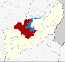
Nam Pat is a district (amphoe) of Uttaradit province, northern Thailand.

<span class="mw-page-title-main">Chiang Khong district</span> District of Thailand

Chiang Khong is a district (amphoe) located in the northeastern part of Chiang Rai province, northern Thailand, with its seat being Wiang. The district borders six other districts in Chiang Rai province, with its north and northeast being bounded by the Mekong River, being connected to Laos on the other side by the Fourth Thai–Lao Friendship Bridge.

<span class="mw-page-title-main">Mueang Phayao district</span> District in Phayao, Thailand

Mueang Phayao is the capital district of Phayao province, northern Thailand.

<span class="mw-page-title-main">Kosum Phisai district</span> District in Maha Sarakham, Thailand

Kosum Phisai is a district (amphoe) in the northern part of Maha Sarakham province, northeastern Thailand.

<span class="mw-page-title-main">Manorom district</span> District in Chai Nat, Thailand

Manorom is a district (amphoe) in the northeastern part of Chai Nat province, central Thailand.

<span class="mw-page-title-main">Mae Tha district, Lampang</span> District in Lampang, Thailand

Mae Tha is a district (amphoe) of Lampang province, northern Thailand.

<span class="mw-page-title-main">Seka district</span> District in Bueng Kan, Thailand

Seka is a district (amphoe) in the eastern part of Bueng Kan province, northeastern Thailand.

<span class="mw-page-title-main">Lam Plai Mat district</span> District in Buriram, Thailand

Lam Plai Mat is a district (amphoe) of Buriram province, northeastern Thailand.

Tha Faek is a tambon (sub-district) of Nam Pat District, in Uttaradit Province, Thailand. In 2014 it had a population of 4,434 people.

Ruam Chit is a tambon (subdistrict) of Tha Pla District, in Uttaradit Province, Thailand. In 2018 it had a total population of 5,540 people.

Lam Nam Nan National Park is a national park in Thailand's Phrae and Uttaradit provinces. The national park covers an area of 999 square kilometres (386 sq mi) and was established in 1998, it is home to rugged mountains and the reservoir of the Sirikit Dam.

Mae Charim Wildlife Sanctuary is a wildlife sanctuary in Ban Khok, Fak Tha and Nam Pat districts of Thailand's Uttaradit Province. The sanctuary covers an area of 660 square kilometres (250 sq mi) and was established in 1998.

References

  1. ประกาศโอนอำเภอท่าปลาจากจังหวัดน่านมาขึ้นจังหวัดอุตรดิตถ์ (PDF). Royal Gazette (in Thai). 39 (ก): 55. 1922-06-04. Archived from the original (PDF) on June 1, 2012.
  2. "Population statistics 2014" (in Thai). Department of Provincial Administration. Retrieved 2015-03-16.
  3. Phuengsuk, Prasit (2019-10-04). "ประเพณีแห่ผีตลกหนึ่งเดียวในโลก" [Phi Talok parade festival, one-of-a-kind in the world]. Thai Rath (in Thai). Retrieved 2019-10-09.