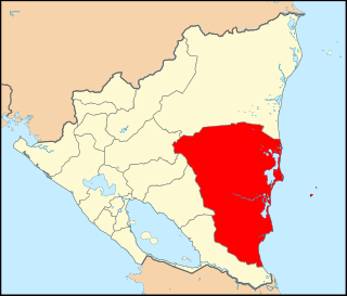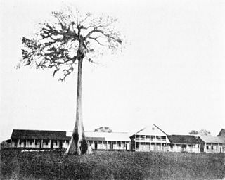
The South Caribbean Coast Autonomous Region is one of two autonomous regions in Nicaragua. It was created along with the North Caribbean Coast Autonomous Region by the Autonomy Statute of 7 September 1987 through a division of the former Zelaya Department. It covers an area of 27,260 km2 (10,530 sq mi) and has a population of 420,935. The capital is Bluefields. Bordering the Caribbean Sea, it contains part of the region known as Mosquitia.
Dolores is a municipality in the Carazo department of Nicaragua. It is the smallest municipality in Nicaragua, as it consists only of the urban area or dwellings of its head town.

Diria is a municipality in the Granada department of Nicaragua.
Tuma-La Dalia is a municipality in the Matagalpa Department of Nicaragua. The municipal seat is the town of La Dalia. The municipality takes its name from its two main towns: El Tuma and La Dalia. It is located 175 kilometers from the capital, Managua, and 45 kilometers from the city of Matagalpa, the departmental capital of the same name.

Nueva Guinea is a town and a municipality in the South Caribbean Coast Autonomous Region of Nicaragua.
Paiwas is a municipality in the South Caribbean Coast Autonomous Region of Nicaragua. The administrative center is the town of Bocana de Paiwas.
El Ayote is a municipality in the South Caribbean Coast Autonomous Region of Nicaragua. The population is 5,406.

Rama is a municipality and a city in the South Caribbean Coast Autonomous Region of Nicaragua.
El Tortuguero is a municipality in the South Caribbean Coast Autonomous Region of Nicaragua. It is located at about 530 km from Managua and can only be reached by an hour-long truck ride from El Rama.
La Cruz de Río Grande is a municipality in the South Caribbean Coast Autonomous Region of Nicaragua. According to the 2005 census, the population of La Cruz de Rio Grande was 3,000. It gets its name from the Rio Grande de Matagalpa which flows through it.
Kukra Hill(Loma de los Kukras) is a municipality in the South Caribbean Coast Autonomous Region in the Republic of Nicaragua. It was granted municipal status in 1989; before then, it was administratively part of the municipality of Bluefields, in the former department of Zelaya.

Angelópolis is a town and municipality in Antioquia Department, Colombia. It borders the municipalities of Armenia, Heliconia, and Medellín to the north; La Estrella and Caldas to the east; Amagá to the south; and Titiribí and Armenia to the west. Its municipal seat is 48 kilometers from the city of Medellín, the capital of the department of Antioquia. The municipality has an area of 86 square kilometers.

Ciudad Hidalgo, or simply Hidalgo, is a city and municipal seat of the Municipality of Hidalgo in the far northeast of the state of Michoacán, Mexico. It is a city located in a rural, mountainous area. While most of the city consists of modern buildings, its principal monument is the 16th-century church and former monastery of San José. Formerly, its name was Taximaroa, and it was the part of the Purépecha Empire closest to the Aztec Empire. This prompted two unsuccessful Aztec invasions as well as the first Spanish incursion into Purépecha lands in 1522. For both the city and rural communities around it, forestry and furniture making are important parts of the economy, but deforestation is forcing the area to look into alternatives such as tourism to take advantage of its natural resources and cultural sites.

Metepec is a municipality in the State of Mexico in Mexico and is located directly to the east of the state capital, Toluca, at an altitude of 2,635 metres (8,645 ft) above sea level. The center of Mexico City lies some 50 km further to the east. The city of Metepec also form part of the Greater Toluca. The name Metepec comes from Náhuatl meaning hill of the agave plants. However, it is also known in the Matlatzinca language as "Nepinta-Tuhi" meaning 'people of corn land' and in the Otomi language as "Ntaguada".

Tello is a town and municipality in the Huila Department, Colombia. It is characterized by its extensive plain between the Magdalena River and the foot of the Cordillera Oriental mountain range up to its peaks, with the Fortalecillas and Villavieja rivers located nearby. Its territorial extension is 589 km², its altitude is 575 meters above sea level and its climate is warm with an average temperature of 26°C.

San Andrés Tuxtla is a city and municipality in the south of the Mexican state of Veracruz. The city is the largest in the Los Tuxtlas region. It was founded after an eruption of the San Martín Volcano pushed people into this valley during the early colonial period. Since the 19th century, the area has been the center of Mexico's production of fine tobacco, mostly used in the making of cigars.

Taxco de Alarcón is a municipality in the Mexican state of Guerrero. It covers an area of 650.7 km² and includes 121 communities. The municipal seat lies at Taxco de Alarcón. The population was 105,586 at the time of the 2020 census.
Calnali is a town and one of the 84 municipalities of Hidalgo, in central-eastern Mexico. The municipality covers an area of 190.2 km². Calnali is a Nahuatl name meaning house on the other side of the river. As of 2005, the municipality had a total population of 15,815.

Zacatlán Municipality is a municipality in the Mexican state of Puebla in south-eastern Mexico. Its administrative centre is the city of Zacatlán.

Xicotlán (municipality) is a town and municipality in the Mexican state of Puebla in south-eastern Mexico.


