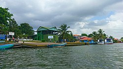
Pearl Lagoon

Last updated
Pearl Lagoon
Municipal wharf of pearl lagoon.jpg
Municipal wharf of Pearl Lagoon
Pearl Lagoon coat of arms.gif
Nicaragua location map.svg
Red pog.svg
Pearl Lagoon
Coordinates: 12°21′N83°40′W / 12.350°N 83.667°W / 12.350; -83.667
Country Flag of Nicaragua.svg  Nicaragua
Department Flag of Region Autonoma Atlantico Sur.svg South Caribbean Coast Autonomous Region
Municipality Pearl Lagoon
SeatPearl City
Government
  Type Mayor
   Mayor Dariel Taylor (FSLN)
Area
   Municipality 1,963 km2 (758 sq mi)
Population
 (2022 estimate) [1]
   Municipality 21,360
  Density11/km2 (28/sq mi)
   Urban
11,170

Pearl Lagoon is a municipality that is often time called just Lagoon and was historically known as English Bank. [2] It is located in the South Caribbean Coast Autonomous Region of Nicaragua. It is the most important town of the largest coastal lagoon also by the name of Pearl Lagoon in the South Caribbean Coast Autonomous Region of Nicaragua and which the name of the town is derived from. As of 2022, Pearl Lagoon Municipality had a population of 21,360.

Contents

History

18th century cannon by Pearl Lagoon 18th century cannon on Pearl Lagoon municipal wharf.jpg
18th century cannon by Pearl Lagoon

Pearl Lagoon, along with the eastern half of present-day Nicaragua, was a British protectorate from 1655 until 1860, a period when the region was called the Mosquito Coast.

In the period before 1894, eastern Nicaragua was a British protectorate, ruled through a line of Miskito kings. About a century ago, Pearl Lagoon was considered to be the second capital of the Moskitian Kingdom when the last Miskito King took up residence in the town of Pearl City, the capital of the municipality.

At that time, Pearl Lagoon was called "the Granada of the Mosquitia" by one of the conquistadores of the Pacific Coast because of its beauty and the booming ship traffic.

An 18th century cannon situated on the municipality wharf of Pearl Lagoon has an inscription commemorating battles between liberal and conservative factions. [3] The cannon was never fired in anger, it was used only for celebrations.

Culture

Most of the inhabitants are Creole, but a large number of Miskito, Mestizo and some Garifuna are also present. The Mestizo people started migrating in the late 90s, some from the city of El Rama and some from the northern part of the municipality of Pearl Lagoon.

Similar to Bluefields, May Pole is a big celebration among the people. Now within the same month of May, people from all over the municipality would come together in the community of Pearl Lagoon to celebrate and share their different cultures and traditions.

The main communities are Haulover, Kakabila, Marshall Point, Pearl Lagoon, Orinoco, La Fe, Raitipura, Brown Bank, Tasbapauni, Set Net Point, Wawashan, San Vicente, Awas and Pedregal. [4]

Sports

Harry and Maggie Taylor Municipal Stadium The Harry and Maggie Taylor municipal stadium.jpg
Harry and Maggie Taylor Municipal Stadium

Pearl Lagoon was the home to four local baseball teams that played during the dry seasons on Sundays. The four teams were: Sweet Pearly, First Stop, The Young Brave, and the Haulover Tigers. [5]

Pitchers Albert Williams and Devern Hansack, both natives of Pearl Lagoon, played in the Major League Baseball. Although those teams no longer exist, baseball is still one of the main sports in the community which is also played in the dry season on Sundays at the Harry and Maggie Taylor municipal stadium.

Transportation

Highway between Pearl Lagoon and Haulover Highway between Pearl Lagoon and Haulover.jpg
Highway between Pearl Lagoon and Haulover

The municipality of Pearl Lagoon is located just north of Bluefields, the capital of the South Caribbean Coast Autonomous Region, and can be reach by boat and Panga boat.

In 2006, the IDR initiated the construction of a new rural road of 17 km from Kukra Hill to Pearl Lagoon. The road is now reconstructed and as of today, it permits direct access to Managua from Pearl Lagoon [6] and was financed by the World Bank (WB) through the International Development Association (IDA).

For more than 10 years, there has been a bus that travels every day from Pearl Lagoon to Kukra Hill and back. Around three years ago, the owner of that same bus started a new destination directly from Pearl Lagoon to Managua one time per week.

Education

In Pearl Lagoon, there are three schools. The Beulah Light Burn school which is only for primary and pre-escolar students, the Pearl Lagoon National Institute only for Secondary students and the Pearl Lagoon Academy of Excellence (PLACE) for pre-escolar, primary and secondary students.

See also

Related Research Articles

<span class="mw-page-title-main">Nicaragua</span> Country in Central America

Nicaragua, officially the Republic of Nicaragua, is the largest country in Central America, bordered by Honduras to the north, the Caribbean to the east, Costa Rica to the south, and the Pacific Ocean to the west. Managua is the country's capital and largest city. As of 2015, it was estimated to be the third largest city in Central America. Nicaragua's multiethnic population of six million includes people of mestizo, Indigenous, European and African heritage. The main language is Spanish. Indigenous tribes on the Mosquito Coast speak their own languages and English.

<span class="mw-page-title-main">Geography of Nicaragua</span> Geographical features of Nicaragua

Nicaragua is a country in Central America, bordering both the Caribbean Sea and the North Pacific Ocean, between Costa Rica and Honduras. Nicaragua is the largest country in Central America in square kilometers.

<span class="mw-page-title-main">Demographics of Nicaragua</span>

According to the 2022 revision of the World Population Prospects, Nicaragua has a population of 6,850,540..According to a 2014 research published in the journal Genetics and Molecular Biology, European ancestry predominates in 69% of Nicaraguans, followed by African ancestry in 20%, and lastly indigenous ancestry in 11%. A Japanese research of "Genomic Components in America's demography" demonstrated that, on average, the ancestry of Nicaraguans is 58–62% European, 28% Native American, and 14% African, with a very small Near Eastern contribution. Non-genetic data from the CIA World Factbook establish that from Nicaragua's 2016 population of 5,966,798, around 69% are mestizo, 17% white, 5% Native American, and 9% black and other races. This fluctuates with changes in migration patterns. The population is 58% urban as of 2013.

<span class="mw-page-title-main">Mosquito Coast</span> Coastline in Central America

The Mosquito Coast is the area along the eastern coast of present-day Nicaragua and Honduras. It was named after the local Miskito Nation and was long dominated by British interests and known as the Mosquito Kingdom. From 1860 suzerainty of the area was transferred to Nicaragua with the name Mosquito Reserve, and in November 1894 the Mosquito Coast was militarily incorporated into Nicaragua. However, in 1960, the northern part was granted to Honduras by the International Court of Justice.

<span class="mw-page-title-main">North Caribbean Coast Autonomous Region</span> Autonomous region of Nicaragua

The North Caribbean Coast Autonomous Region is one of two autonomous regions in Nicaragua. It was created along with the South Caribbean Coast Autonomous Region by the Autonomy Statute of 7 September 1987 through a division of the former Zelaya Department. It covers an area of 33,106 km2 and has a population of 541,189. It is the largest autonomous region or department in Nicaragua. The capital is Puerto Cabezas. It contains part of the region known as the Mosquito Coast.

<span class="mw-page-title-main">South Caribbean Coast Autonomous Region</span> Autonomous region of Nicaragua

The South Caribbean Coast Autonomous Region is one of two autonomous regions in Nicaragua. It was created along with the North Caribbean Coast Autonomous Region by the Autonomy Statute of 7 September 1987 through a division of the former Zelaya Department. It covers an area of 27,260 km2 (10,530 sq mi) and has a population of 420,935. The capital is Bluefields. Bordering the Caribbean Sea, it contains part of the region known as Mosquitia.

<span class="mw-page-title-main">Bluefields</span> Municipality in South Caribbean Autonomous Region, Nicaragua

Bluefields is the capital of the South Caribbean Autonomous Region in Nicaragua. It was also the capital of the former Kingdom of Mosquitia, and later the Zelaya Department, which was divided into North and South Caribbean Coast Autonomous Regions. It is located on Bluefields Bay at the mouth of the Bluefields River in the municipality of the same name.

Mískito Coast Creole or Nicaraguan Creole English is an English-based creole language spoken in coastal Nicaraguan region of Mosquito Coast on the Caribbean Sea; its approximately 40,000 speakers are spread over the RAAN and RAAS regions of Nicaragua. The region, known before 1986 as the Zelaya department, is today administratively separated into two autonomous regions: North Caribbean Coast (RAAN) and South Caribbean Coast (RAAS). Mosquito is the nickname that is given to the region and earlier residents by early Europeans who visited and settled in the area. The term "Miskito" is now more commonly used to refer to both the people and the language.

<span class="mw-page-title-main">Rosita, Nicaragua</span> Municipality in North Caribbean Autonomous Region, Nicaragua

Rosita is a town and a municipality in the North Caribbean Autonomous Region of Nicaragua.

<span class="mw-page-title-main">Siuna</span> Municipality in North Caribbean Autonomous Region, Nicaragua

Siuna is a county-sized administrative municipality in Nicaragua, located approximately 318 kilometres (198 mi) northeast of the capital city of Managua and 218 kilometres (135 mi) west of the coastal city and regional capital Puerto Cabezas in the North Caribbean Autonomous Region (RACN). Siuna is the name of the city as well as the municipality. The municipality of Siuna contains 204 rural communities and 20 neighborhoods. Most were settled in support of gold mining along the Ei River drainage basin, leading to rapid population growth from the mid-1930s.

Karawala is a municipality of the South Caribbean Coast Autonomous Region in the Republic of Nicaragua. The head town is the locality of Karawala.

<span class="mw-page-title-main">El Rama</span> Municipality in South Caribbean Coast Autonomous Region, Nicaragua

Rama is a municipality and a city in the South Caribbean Coast Autonomous Region of Nicaragua.

El Tortuguero is a municipality in the South Caribbean Coast Autonomous Region of Nicaragua. It is located at about 530 km from Managua and can only be reached by an hour-long truck ride from El Rama.

Kukra Hill(Loma de los Kukras) is a municipality in the South Caribbean Coast Autonomous Region in the Republic of Nicaragua. It was granted municipal status in 1989; before then, it was administratively part of the municipality of Bluefields, in the former department of Zelaya.

<span class="mw-page-title-main">Corn Islands</span> Municipality in South Caribbean Coast Autonomous Region, Nicaragua

The Corn Islands are two islands about 70 kilometres (43 mi) east of the Caribbean coast of Nicaragua, constituting one of 12 municipalities of the South Caribbean Coast Autonomous Region of Nicaragua. The official name of the municipality is Corn Island.

<span class="mw-page-title-main">Index of Nicaragua-related articles</span>

The following is an alphabetical list of topics related to Nicaragua.

<span class="mw-page-title-main">Languages of Nicaragua</span> Languages of the country and its peoples

The official language of Nicaragua is Spanish; however, Nicaraguans on the Caribbean coast speak indigenous languages and also English. The communities located on the Caribbean coast also have access to education in their native languages. Additionally, Nicaragua has four extinct indigenous languages.

<span class="mw-page-title-main">Afro-Nicaraguans</span> Nicaraguans of African descent

Afro-Nicaraguans are Nicaraguans of Sub-Saharan African descent. Five main distinct ethnic groups exist: The Creoles who descend from Anglo-Caribbean countries and many of whom still speak Nicaragua English Creole, the Miskito Sambus descendants of Spanish slaves and indigenous Central Americans who still speak Miskito and/or Miskito Coast Creole, the Garifunas descendants of Zambos expelled from St. Vincent who speak Garifuna, the Rama Cay zambos a subset of the Miskito who speak Rama Cay Creole, and the descendants of those enslaved by the Spanish.

Settlement of English people along the Caribbean Coast, or Miskito Coast, of Nicaragua began in 1633. The area was controlled by Britain until 1860, and eventually integrated into Nicaragua by 1894. The Miskito Coast region divided into two autonomous regions within Nicaragua after 1987.

<span class="mw-page-title-main">June Beer</span> Afro-Nicaraguan artist and poet

June Beer (1935–1986) was a Nicaraguan naïve artist, who gained national and international acclaim for her works depicting African and feminist themes. She was also the first woman poet of Nicaragua's Atlantic coast and produced works in Miskito Coast Creole, English and Spanish. The Nicaraguan government protected four of her paintings—Fruit Seller, In Memory of Efie Irene, They Dance and Woman Working—by declaring them as part of the national patrimony. Removing them from the country is illegal.

References

  1. Citypopulation.de Population of Pearl Lagoon municipality
  2. Baracco, Luciano (2011). National Integration and Contested Autonomy: The Caribbean Coast of Nicaragua. ISBN   9780875868233.
  3. "Tours hotels packages and transports of Nicaragua by Nicatour". www.nicatour.net.
  4. "La Prensa, El Diario de los Nicaraguenses - Servicios - Guía Turística". Archived from the original on 2007-02-18.
  5. "Pearl Lagoon, Nicaragua". Archived from the original on 2007-01-12. Retrieved 2007-02-19.
  6. http://www.idr.gob.ni/notas%20de%20prensa/laguna%20de%20perla.pdf%5B%5D