
Kargil district is a district in Indian-administered Ladakh in the disputed Kashmir-region, which is administered as a union territory of Ladakh. It is named after the city of Kargil, where the district headquarters lies. The district is bounded by the Indian-administered union territory of Jammu and Kashmir to the west, the Pakistani-administered administrative territory of Gilgit–Baltistan to the north, Ladakh's Leh district to the east, and the Indian state of Himachal Pradesh to the south. Encompassing three historical regions known as Purig, Dras and Zanskar, the district lies to the northeast of the Great Himalayas and encompasses the majority of the Zanskar Range. Its population inhabits the river valleys of the Dras, Suru, Wakha Rong, and Zanskar.

Doda district is an administrative district of the Jammu division of Indian-administered Jammu and Kashmir in the disputed Kashmir region. Doda covers 2,625 square kilometers.
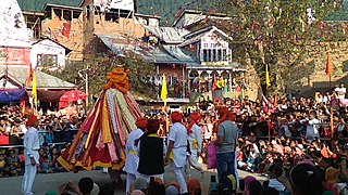
Bhaderwah or Bhadarwah is a town, tehsil, and sub-district in the Doda district of Jammu Division of Jammu and Kashmir, India.

The Pir Panjal Range is a range of mountains in the Lower Himalayan region located in the Western Himalayas of northern Indian subcontinent. It runs southeast to northwest between the Beas and Neelam/Kishanganga rivers, in the Indian state of Himachal Pradesh and Indian-administered union territory of Jammu and Kashmir, with its northwestern end extending into territory administered by Pakistan. The Himalayas show a gradual elevation towards the Dhauladhar and Pir Panjal ranges. Pir Panjal is the largest and westernmost range of the Lesser Himalayas. Near the bank of the Sutlej River, it dissociates itself from the main Himalayan range and forms a divide between the Beas and Ravi rivers on one side and the Chenab on the other. Further west, the Pir Panjal range forms the southwestern boundary of the Kashmir Valley, separating it from the hills of Jammu region, forming a divide between the Jhelum and Chenab rivers.

Jammu and Kashmir is home to several valleys such as the Kashmir Valley, Chenab Valley, Sindh Valley and Lidder Valley. Some major tourist attractions in Jammu and Kashmir are Srinagar, with its renowned Dal Lake and Mughal Gardens, Gulmarg, Pahalgam, Bhaderwah, Patnitop and Jammu. Every year, thousands of Hindu pilgrims visit holy shrines of Vaishno Devi and Amarnath which has had a significant impact on the state's economy.
Ramban district is an administrative district in the Jammu division of Indian-administered Jammu and Kashmir in the disputed Kashmir region. It is located in a valley surrounded the Pir Panjal range. It was carved out as a separate district from erstwhile Doda district in 2007. It is located in the Jammu division. The district headquarters are at Ramban town, which is located midway between Jammu and Srinagar along the Chenab river in the Chenab valley on National Highway-44, approximately 151 km from Jammu and Srinagar.

The Ganderbal district, is an Indian-administered district in Jammu and Kashmir in the disputed Kashmir region. It was formed in 2007 and has 6 subdistricts (tehsils): Kangan, Ganderbal, Tullamulla, Wakura, Lar, and Gund.

Kishtwar district is an administrative district of the Jammu division of Indian-administered Jammu and Kashmir of the disputed Kashmir region. As of 2011, it is the largest and the least populous district of the Union Territory of Jammu and Kashmir.
Keran is a tehsil in Kupwara district, Jammu and Kashmir, India. It is on the bank of the Kishanganga River. The village lies on the Line of Control. The Keran block includes four panchayats: Keran, Mandian, Mandian-A and Kundian Pathroo.
Surankote is a town in the Surankote Tehsil of the Poonch district of the Indian union territory of Jammu and Kashmir. It occupies the Surankote valley, located between the Pir Panjal and ranges within the Himalayas. It receives snowfall in winters. It is famous for the existence of lakes on the Pir Panjal range which are not still connected with the outside world. Although some people visit these lakes by foot for recreation and refreshment.
Salooni is the tehsil headquarter and Sub-Division in Chamba district of Himachal Pradesh, India. Salooni is an important regional administrative and economic centre. It has a mini secretariat, SDM office, government senior secondary school, Degree College, CSK HP Krishi Vishvavidyalaya Mountain Agriculture Research and Extension Stations, community health centre and many other sub-division level important government offices. Salooni falls under Dalhousie legislative constituency. The entrance to the small township has a series of few quaint shops, followed by small ground with an ancient goddess Kali temple at other end.

Chenab Valley is a term refers to present-day districts of Doda, Kishtwar, Ramban in Jammu and Kashmir. These three districts used to be part of a single former district called Doda, which was created in 1948 out of the eastern parts of Udhampur district of the princely state of Jammu and Kashmir, and are sometimes collectively referred to as the Doda belt.

Sinthan Top is a mountain pass, a popular tourist destination located in Kishtwar district and borders with South Kashmir's Breng Valley of Anantnag district in the Indian union territory of Jammu and Kashmir. Majority of the area lies on the Kishtwar side. The top acts as a sort of base camp to several alpine lakes in the region.

Khag is a tehsil in and block in the Beerwah sub-district of the Budgam district in the Indian union territory of Jammu and Kashmir. It is 8.8 km (5.5 mi) away from sub-district headquarter Beerwah and 35 km (22 mi) away from Srinagar, the summer capital of Jammu and Kashmir.

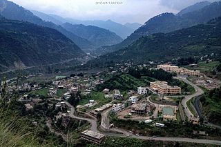
Thathri is a town and a notified area committee in Doda district in the Indian union territory of Jammu and Kashmir. Thathri valley is located in the foothills of the Himalayan mountains, about 85 km from Batote. Apart from having ample forests, the town contains many small streams flowing through its various parts. It is located on the banks of the Chenab River and the town area is spread over 1.50 sq. Km².
Bufliaz, or Bafliaz, is a village and the headquarters of the eponymous community development block in Surankote tehsil of Poonch district in the Jammu division of Jammu and Kashmir, India. It lies on the Poonch–Rajouri road and is also the starting point of the Mughal Road that leads into the Kashmir Valley through Shopian.
The Warwan Valley is a Himalayan sub-valley and a tehsil in Kishtwar District in the Jammu division in union territory of Jammu and Kashmir in India. The Valley lies 68 kilometres (42 mi) northeast of Kishtwar and 150 kilometres (93 mi) from Srinagar, the summer capital of Jammu and Kashmir.

Bunjwah is a region and tehsil located in the Kishtwar district of Jammu and Kashmir, India. It comprises nine panchayat and two nayabats; it became a tehsil in 2014.
Mulwarwan is a remote village located in the Warwan Valley of the Kishtwar district in the Union Territory of Jammu and Kashmir, India. Located in the Himalayan mountains, Mulwarwan is known for its high-altitude location and harsh winter conditions, with limited access to infrastructure and services.
Dhadpeth is a village in the Mughal Maidan tehsil of Kishtwar district, in the Indian union territory of Jammu and Kashmir.

