Related Research Articles
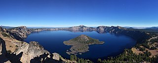
Crater Lake National Park is an American national park located in southern Oregon. Established in 1902, Crater Lake is the fifth-oldest national park in the United States and the only national park in Oregon. The park encompasses the caldera of Crater Lake, a remnant of Mount Mazama, a destroyed volcano, and the surrounding hills and forests.
Landforms are categorized by characteristic physical attributes such as their creating process, shape, elevation, slope, orientation, rock exposure, and soil type.

Jeju Province, officially Jeju Special Self-Governing Province, is the southernmost province of South Korea, consisting of 8 inhabited and 55 uninhabited islands, including Mara Island, U Island, the Chuja Archipelago, and the country's largest island Jeju Island. The province is located in the Korea Strait, with the Korean Peninsula to the northwest, Japan to the east, and China to the west. The province has two cities: the capital Jeju City, located on the northern half of the island and Seogwipo, located on the southern half of the island. The island is home to the shield volcano Hallasan, the highest point in South Korea. Jeju and Korean are the official languages of the province, and the vast majority of residents are bilingual in both languages.

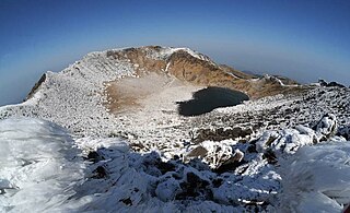
Hallasan (Korean: 한라산) is a shield volcano on Jeju Island in South Korea. Its summit, at 1,947 m (6,388 ft), is the highest point in the country. The area around the mountain is a designated national park, the Hallasan National Park. Hallasan is commonly considered to be one of the three main mountains of South Korea, along with Jirisan and Seoraksan.

Mývatn is a shallow lake situated in an area of active volcanism in the north of Iceland, not far from Krafla volcano. It has a high amount of biological activity. The lake and the surrounding wetlands provides a habitat for a number of waterbirds, especially ducks. The lake was created by a large basaltic lava eruption 2300 years ago, and the surrounding landscape is dominated by volcanic landforms, including lava pillars and rootless vents (pseudocraters). The effluent river Laxá[ˈlaksˌauː] is known for its rich fishing for brown trout and Atlantic salmon.

A parasitic cone is the cone-shaped accumulation of volcanic material not part of the central vent of a volcano. It forms from eruptions from fractures on the flank of the volcano. These fractures occur because the flank of the volcano is unstable. Eventually, the fractures reach the magma chamber and generate eruptions called flank eruptions, which, in turn, produce a parasitic cone.
Jeju Island is South Korea's largest island, covering an area of 1,833.2 km2 (707.8 sq mi), which is 1.83 percent of the total area of the country. It is also the most populous island in South Korea; at the end of September 2020, the total resident registration population of Jeju Province is 672,948, of which 4,000 reside on outlying islands such as the Chuja Islands and Udo Island. The total area of the Jeju Special Self-Governing Province is 1,849 km2 (714 sq mi).

Mount Karthala or Karthola is an active volcano and the highest point of the Comoros at 2,361 m (7,746 ft) above sea level. It is the southernmost and larger of the two shield volcanoes forming Grande Comore island, the largest island in the nation of Comoros. The Karthala volcano is very active, having erupted more than 20 times since the 19th century. Frequent eruptions have shaped the volcano's 3 km by 4 km summit caldera, but the island has largely escaped broad destruction. Eruptions on April 17, 2005 and May 29, 2006 ended a period of quiet.

Korea comprises the Korean Peninsula and 3,960 nearby islands. The peninsula is located in Northeast Asia, between China and Japan. To the northwest, the Amnok River separates Korea from China and to the northeast, the Duman River separates Korea from China and Russia. The Yellow Sea lies to the west, the East China Sea and Korea Strait to the south, and the Korean East Sea to the east. Notable islands include Jeju Island (Jejudo), Ulleung Island (Ulleungdo), and the Liancourt Rocks.
The Jeju Volcanic Island and Lava Tubes is a World Heritage Site in South Korea. It was inscribed as one of the UNESCO World Heritage Sites in 2007 because of the Geomunoreum Lava Tube System and the exhibition of diverse and accessible volcanic features which are considered to demonstrate a distinctive and valuable contribution to the understanding of global volcanism.

The black paradise flycatcher, also known as the Japanese paradise flycatcher, is a medium-sized passerine bird native to southeastern Asia. It is a glossy black, chestnut and white bird, slightly smaller than either the Amur paradise flycatcher or Blyth's paradise flycatcher, but similar in appearance. Males have exceptionally long tails. Females are generally duller in appearance and have shorter tails.
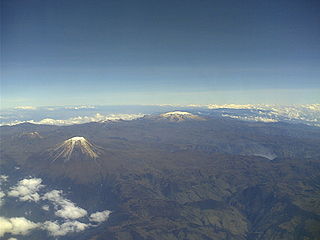
Los Nevados National Natural Park is a national park located in the Cordillera Central of the Colombian Andes. The park surrounds the northern volcanic complex formed by Nevado del Ruiz, Nevado del Tolima, Nevado de Santa Isabel, the paramillos of Cisne, Santa Rosa and Quindío and the Cerro Bravo and Cerro Machín.

Gotjawal Forest is a naturally formed forest located on the middle slopes of Halla Mountain, Jeju Island in South Korea. It covers the rocky area of ʻaʻā on Jeju Island off the southwestern coast of South Korea. Due to the geographical feature, the region remains largely undisturbed by people. The Gotjawal Forest is an enclave of the Southern Korea evergreen forests ecoregion, and is a favorite place of the Jeju locals.

Lake Nemrut is a freshwater crater lake in Bitlis Province, eastern Turkey. It is part of Nemrut Caldera, a volcanic caldera atop Volcano Nemrut. The government of Turkey has named as its 14th Wetland of International Importance the Nemrut Caldera. With its structural morphology that is unique in Turkey, the site qualifies for the Ramsar List under Criterion 1 on "representative, rare, or unique examples of a natural or near-natural wetland type found within the appropriate biogeographic region".
Hallasan National Park is located in the province of Jeju-do, South Korea. It was designated as the 9th national park in 1970. It features the highest mountain in South Korea, the shield volcano Hallasan on Jeju Island. It was designated a UNESCO Biosphere Reserve in 2002, and a World Heritage Site in 2007.
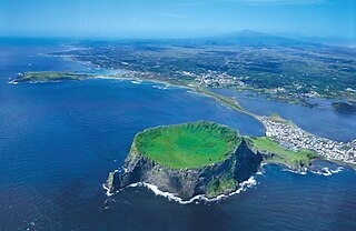
Seongsan Ilchulbong, also called ‘Sunrise Peak’, is an archetypal tuff cone formed by hydrovolcanic eruptions upon a shallow seabed about 5 thousand years ago. Situated on the eastern seaboard of Jeju Island and said to resemble a gigantic ancient castle, this tuff cone is 182 meters high, has a preserved bowl-like crater and also displays diverse inner structures resulting from the sea cliff. These features are considered to be of geologic worth, providing information on eruptive and depositional processes of hydromagmatic volcanoes worldwide as well as past volcanic activity of Seongsan Ilchulbong itself.
Mt. Songak (Korean: 송악산) is a volcano on Jeju Island which has double craters and a parasitic cone. Crater 1 is about 500 m in diameter, 1.7 km in circumference. Crater 2, the mouth of the volcano in Crater 1, is about 400 m in diameter, 69 m in depth and leans vertically.
Jeju Oreum is a rising small defunct volcano in the Jeju Island in South Korea. The word "oreum" is the Jeju dialect which implies the parasitic cone [Hangul: 측화산, Hanja: 側火山 and the origin of the word "oreum" is a noun type of the word "climb". The name refers to a small volcano within a main volcanic crater in Jeju-do and is usually applied to the hill in Jeju. The cinder cone, symbolizing the oreum, is a typical form of Jeju Oreum. The Oreum is divided into pyroclastic cone, tuff cone and lava dome depending on the nature of volcanic eruptions. The pyroclastic cones are volcanic bodies formed by the accumulation of volcanic clusters released into the air by an explosive eruption.
Lake Meke is a volcanic crater lake composed of two nested lakes located in Konya Province, central Turkey. It is a registered natural monument of the country and a Ramsar site. Lake Meke is located in Karapınar district of Konya Province. It is 9 km (5.6 mi) away from Karapınar, and 2 km (1.2 mi) south of the Konya-Adana highway E981.

A volcanic crater lake is a lake in a crater that was formed by explosive activity or a collapse during a volcanic eruption.
References
- ↑ "jejuoreum". jejuoreum.
Information sheet on Ramsar Wetlands [ permanent dead link ]