Municipality of Lovrenc na Pohorju Občina Lovrenc na Pohorju | |
|---|---|
 | |
Flag  Coat of arms | |
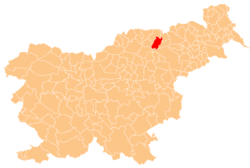 Location of the Municipality of Lovrenc na Pohorju in Slovenia | |
| Coordinates: 46°32′17″N15°23′3″E / 46.53806°N 15.38417°E | |
| Country | |
| Government | |
| • Mayor | Joško Manfreda (Independent) |
| Area | |
• Total | 84.4 km2 (32.6 sq mi) |
| Population (2013) [1] | |
• Total | 3,096 |
| • Density | 36.7/km2 (95.0/sq mi) |
| Time zone | UTC+01 (CET) |
| • Summer (DST) | UTC+02 (CEST) |
| Website | www |
The Municipality of Lovrenc na Pohorju is a municipality in northeastern Slovenia. It lies in the Pohorje Hills to the west of Maribor. The area is part of the traditional region of Styria. It is now included in the Drava Statistical Region. [2] The settlement of Lovrenc na Pohorju is the seat of the municipality.