Murkongselek railway station

Last updated

Murkongselek
Indian Railways Suburban Railway Logo.svg
General information
Location Murkongselek, Jonai, Dhemaji district, Assam
India
Coordinates 27°49′45″N95°13′09″E / 27.8291°N 95.2192°E / 27.8291; 95.2192
Elevation132 metres (433 ft)
Owned by Indian Railways
Operated by Northeast Frontier Railway
Line(s) Rangiya–Murkongselek section
Platforms3
Tracks5
ConnectionsAuto stand, Rikshaw,
Construction
Structure typeStandard (on ground station)
Parking BSicon PARKING.svg Available
Bicycle facilities BSicon BICYCLE.svg Available
Other information
StatusSingle diesel line
Station codeMZS
Zone(s) Northeast Frontier Railway
Division(s) Rangiya
History
Rebuilt2015
ElectrifiedOngoing
Passengers
5K/Day
Services
Waiting Room - The Noun Project.svg AB-Autobahnkiosk.svg BSicon REST.svg
Location
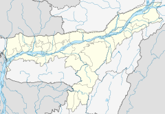
India Assam location map.svg
Red pog.svg
Murkongselek
Location in Assam
India location map.svg
Red pog.svg
Murkongselek
Location in India

Murkongselek Railway Station is a main railway station in Dhemaji district, Assam. Its code is MZS. It serves Murkongselek town. The station consists of three platforms. The station has been upgraded to a standard Class II Station. [1] . [2] [3] [4] It is a railway station which connects Assam to Arunachal Pradesh.
Contents

Station details

Platforms

There are a total of 3 platforms and 5 tracks. The platforms are connected by foot overbridge. These platforms are built to accommodate 24 coaches express train.

Murkongselek railway station has a separate platform for receiving and unloading freight (goods) trains.

Station layout

GStreet levelExit/Entrance & ticket counter
P1 FOB, Side platform, No-1 doors will open on the left/right
Track 1
Track 2
FOB, Island platform, No- 2 doors will open on the left/right
Island platform, No- 3 doors will open on the left/right
Track 3
Track 4For freight trains
Track 5For freight trains

Major Trains

Underconstruction new rail lines

227 km Murkongselek–Pasighat–Tezu–Rupai line is being undertaken as a strategic project. [5] [6]

Nearest airport

The nearest airports are Dibrugarh Airport, Lilabari Airport at Lakhimpur district, Pasighat Airport at Arunachal Pradesh.( Nearly 37 km).

See also

Related Research Articles

<span class="mw-page-title-main">Northeast Frontier Railway zone</span> Indian railway zone

The Northeast Frontier Railway is one of the 19 railway zones of the Indian Railways. It is headquartered in Maligaon, Guwahati in the state of Assam, and responsible for operation and expansion of rail network all across Northeastern states and some districts of eastern Bihar and northern West Bengal.

<span class="mw-page-title-main">Pasighat</span> Town in Arunachal Pradesh, India

Pasighat is the headquarters of East Siang district in the Indian state of Arunachal Pradesh. Situated at the eastern foothills of the Himalayas at 155 metres (509 ft) above mean sea level, Pasighat is Arunachal's oldest town. The Government of India included Pasighat in the Smart Cities Mission development scheme in June 2017.

Tezu is a census town and the headquarters of Lohit district in the Indian state of Arunachal Pradesh. It is the fifth largest town in Arunachal Pradesh and one of its most developed.

<span class="mw-page-title-main">Yingkiong</span> Town in Arunachal Pradesh, India

Yingkiong is a town in and the administrative headquarters of Upper Siang district in the Northeast Indian state of Arunachal Pradesh. It is located 250 kilometres (160 mi) north of Itanagar, the capital of the state, and 1 kilometre (0.62 mi) east of the River Siang. According to the 2011 Census, the town has a total population of 8,573.

<span class="mw-page-title-main">Aalo</span> District Headquarters in Arunachal Pradesh, India

Aalo, formerly Along, is a census town and headquarter of the West Siang district district of the Indian state of Arunachal Pradesh. It is located 137 kilometres (85 mi) from Likabali, which is at the border of Assam and Arunachal Pradesh.

<span class="mw-page-title-main">Rangiya</span> City in Assam, India

Rangiya also known as Rangia, is a major city of Lower Assam division and a municipal board located in the Kamrup district of Assam, India. Rangiya is also the headquarters of Kamrup district, and Rangiya serves as the Sub-divisional headquarter of Rangiya Sub-division. One of Rangiya's significant features is its role as the divisional headquarter of the Northeast Frontier Railway, which is one of the major railway zones in India. Baralia river flows through the heart of the city. The Redhorn Division of the Indian Army is located just three kilometers from the city.

<span class="mw-page-title-main">Bhalukpong</span> Town in Arunachal Pradesh, India

Bhalukpung is a small town located along the southern reaches of the Himalayas in West Kameng district of Arunachal Pradesh in India. The town is located at 213m above sea level, 100 km from Bomdila, 52 km from Tezpur and 5 km from Tipi. It lies along the Kameng river and is the headquarters of Bhalukpung circle. A road leads to Bomdila via the Tipi Orchidariurm, and the inner line check post is located at Bhalukpung. It has a railway station namely Bhalukpong Railway Station, connected to Rangiya Murkongselek rail line at Balipara. It has 3 platforms. One pair of trains runs daily to and from here.

The Ministry of Development of North Eastern Region is a Government of India ministry, established in September 2001, which functions as the nodal Department of the Central Government to deal with matters related to the socio-economic development of the eight States of Northeast India: Arunachal Pradesh, Assam, Manipur, Meghalaya, Mizoram, Nagaland, Tripura and Sikkim. It acts as a facilitator between the Central Ministries/ Departments and the State Governments of the North Eastern Region in the economic development including removal of infrastructural bottlenecks, provision of basic minimum services, creating an environment for private investment and to remove impediments to lasting peace and security in the North Eastern Region.

<span class="mw-page-title-main">Project Unigauge</span> Ongoing nationwide standardisation of railway track gauge in India

Project Unigauge, started on 1 April 1992, is an ongoing effort by Indian Railways to convert and unify all rail gauges in India to 1,676 mm broad gauge.

Jonai is a subdivision of Dhemaji District in India's Assam State.It's is located in the eastern part of northeast and it has the last rail station in Dhemaji District. It's local habitats are the Mising. Some tourist attractions are in 3 miles, Torajan no 1

Murkongselek is a village in Assam. It is located in the north-eastern part of Dhemaji district, 42 km from Pasighat in Arunachal Pradesh. Tourist attractions are located nearby in Torajan dolung Jonai and Silapathar. The village also has a railway station. It is around 540 km from Guwahati. Nearest airport is pasighat Airport, Dibrugarh.

<span class="mw-page-title-main">Rangiya Junction railway station</span> Railway station in Assam, India

Rangiya Junction Railway Station is a junction station on the New Bongaigaon–Guwahati section of Barauni–Guwahati line, and Rangia–Tezpur line of Rangiya–Murkongselek section. It is located in Kamrup district in the Indian state of Assam. It serves Rangiya and the surrounding areas.. Rangiya Junction is the 4th largest railway station in Northeast India.

<span class="mw-page-title-main">Rangiya–Murkongselek section</span> Railway line in India

The Rangiya–Murkongselek section is a 450 km (280 mi) long railway line connecting Rangiya in Kamrup district with Murkongselek in Dhemaji district in the Indian state of Assam. The entire section is under the jurisdiction of Northeast Frontier Railway.

Arunachal Junction Railway Station is a small railway station in Silchar Cachar district, Assam. Its code is ARCL.

Viswanath Charali railway station is a main railway station in Biswanath Chariali, Assam. Its code is VNE. It serves Biswanath Chariali town. The station consists of three platforms. The station has been upgraded to a standard Class III Station.

North Lakhimpur railway station is a main railway station in Lakhimpur district, Assam. Its code is NLP. It serves North Lakhimpur city. The station consists of three platforms. The station is considered as Gateway to Arunachal.

<span class="mw-page-title-main">Guwahati–Dekargaon Intercity Express</span>

Guwahati–Dekargaon Intercity Express is an intercity train belonging to Northeast Frontier Railway zone that runs between Guwahati and Dekargaon. It is currently being operated with 15815/15816 train numbers on a daily basis.

Katakhal Junction railway station is a main railway station in Hailakandi district, Assam. Its code is KTX. It serves Katakhal town. The station consists of two platforms.

Rangapara North Junction Railway Station is a main railway station in Sonitpur district, Assam. Its code is RPAN. It serves Rangapara town. The station consists of 5 platforms. This station has been upgraded to a standard B Class Station.

<span class="mw-page-title-main">Tatibahar railway station</span> Railway station in Assam, India

Tatibahar Railway Station is a main railway station in Lakhimpur district, Assam. Its code is TBH. It serves Narayanpur town and nearby areas. The station consists of three platforms.

References

  1. "MZS/Murkongselek". India Rail Info.
  2. The last MG section of Northeast converted into BG
  3. Entire NE converted into BG line: NFR
  4. Strengthening railway infrastructure and boosting connectivity in North East
  5. India to construct strategic railway lines along border with China, Hindustan Times, 30 November 2016.
  6. 2019 target to survey 3 strategic rail lines along China border, Arunachal Observer, 5 January 2019.