
K2, at 8,611 metres (28,251 ft) above sea level, is the second-highest mountain on Earth, after Mount Everest. It lies in the Karakoram range, partially in the Gilgit-Baltistan region of Pakistan-administered Kashmir and partially in a China-administered territory of the Kashmir region included in the Taxkorgan Tajik Autonomous County of Xinjiang.

MacGillycuddy's Reeks is a sandstone and siltstone mountain range in the Iveragh Peninsula in County Kerry, Ireland. Stretching 19 kilometres, from the Gap of Dunloe in the east, to Glencar in the west, the Reeks is Ireland's highest mountain range, and includes most of the highest peaks and sharpest ridges in Ireland, and the only peaks on the island over 1,000 metres in height.

The Berwyn range is an isolated and sparsely populated area of moorland in the northeast of Wales, roughly bounded by Llangollen in the northeast, Corwen in the northwest, Bala in the southwest, and Oswestry in the southeast.

Mount Elbrus is the highest and most prominent peak in Russia and Europe. It is situated in the western part of the Caucasus and is the highest peak of the Caucasus Mountains. The dormant volcano rises 5,642 m (18,510 ft) above sea level; it is the highest stratovolcano in Eurasia, as well as the tenth-most prominent peak in the world. The mountain stands in Southern Russia, in the Russian republic of Kabardino-Balkaria.

The Brienzer Rothorn is a mountain of the Emmental Alps, in Switzerland. With an elevation of 2,350 metres (7,710 ft) above sea level, the Brienzer Rothorn is the highest summit of the range. To its west lies the Tannhorn, whilst to its east are Arnihaaggen, Höch Gumme and the Brünig Pass. On its south side it overlooks Lake Brienz, whilst to the north it looks out over the Waldemme valley.

In these lists of mountains in Ireland, those within Northern Ireland, or on the Republic of Ireland – United Kingdom border, are marked with an asterisk, while the rest are within the Republic of Ireland. Where mountains are ranked by height, the definition of the topographical prominence used to classify the mountain, is noted. In British definitions, a height of 600 metres (1,969 ft) is required for a mountain, whereas in Ireland, a lower threshold of 500 metres (1,640 ft) is sometimes advocated.
Cadair Berwyn or Cader Berwyn is a mountain summit in north-east Wales with a height of 832 metres (2,730 ft) above sea level. It is the highest point in the Berwyn range, the highest in North East Wales and the highest significant summit in Wales outside the National Parks. Cadair Berwyn and Foel Cedig to the west are the two Marilyns that form the Berwyn range. The undulating plateau of the range also includes a large number of other summits above 2,000 feet (610 m), including satellite summits of Cadair Berwyn and many which are classed as Nuttalls.

The Dom is a mountain of the Pennine Alps, located between Randa and Saas-Fee in the canton of Valais in Switzerland. With a height of 4,545 m (14,911 ft), it is the seventh highest summit in the Alps, overall. Based on prominence, it can be regarded as the third highest mountain in the Alps, and the second highest in Switzerland, after Monte Rosa. The Dom is the main summit of the Mischabel group, which is the highest massif lying entirely in Switzerland.
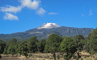
La Malinche, also known as Matlalcueye or Malintzin, is an active volcano located in the states of Tlaxcala and Puebla in Mexico. Officially, its summit reaches 4,461 metres (14,636 ft) above sea level, though it is generally considered to be closer to 4,440 metres (14,567 ft), using GPS measurements. It is the highest peak in Tlaxcala, the fifth-highest in Puebla, the sixth-highest in Mexico, the 23rd-highest in North America, and the 252nd-highest in the world. Its height above nearby cities varies from 1,908 metres (6,260 ft) above Huamantla, 2,461 metres (8,074 ft) above Villa Vicente Guerrero, 2,221 metres (7,287 ft) above Tlaxcala, to 2,299 metres (7,543 ft) above Puebla. The summit is 22.4 kilometres (13.9 mi) from Tlaxcala, 28.3 kilometres (17.6 mi) from Puebla, and 118 kilometres (73 mi) from Mexico City. The climate is cold near the summit and mild on the lower slopes.

Summit Lake Provincial Park is a Class C provincial park located southeast of the community of Summit Lake in the Central Kootenay region of British Columbia, Canada.

The mountains and hills of the British Isles are categorised into various lists based on different combinations of elevation, prominence, and other criteria such as isolation. These lists are used for peak bagging, whereby hillwalkers attempt to reach all the summits on a given list, the oldest being the 282 Munros in Scotland, created in 1891.

The Glärnisch is a mountain massif of the Schwyz Alps, overlooking the valley of the Linth in the Swiss canton of Glarus. It consists of several summits, of which the highest, Bächistock, is 2,915 metres above sea level. Until 2013, the highest point was considered to be an unnamed point with a summit cross at 2,914 metres. The other main summits are Vrenelisgärtli and the Ruchen.

Les Droites is a mountain in the Mont Blanc massif in the French Alps and is the lowest of the 4000-metre peaks in the Alps. The mountain has two summits:

The Helsenhorn is a mountain of the Lepontine Alps, overlooking Binn in the Swiss canton of Valais. With a height of 3,272 metres above sea level, it is the highest summit of the Binntal. The border with Italy runs approximately 200 metres south-east of the summit and culminates at 3,247 metres.

Piz Terri is a mountain in the Lepontine Alps, located on the border between the cantons of Ticino and Graubünden. At 3,149 metres above sea level it is the highest summit lying on the chain between Greina and Soreda Pass. Piz Terri overlooks Lake Luzzone in Val Blenio on its west side, Val Sumvitg on its north side and Lumnezia on its east side. Close localities are Olivone and Vrin (Lumnezia).

Piz Medel is a mountain in the Lepontine Alps, located on the border between the cantons of Ticino and Graubünden. At 3,210 metres (10,531 ft) above sea level it is the highest summit on the chain between Lukmanier Pass and Crap la Crusch. The mountain overlooks the Greina, an important pass connecting the cantons of Graubünden and Ticino.

Piz Languard is a mountain of the Livigno Alps, overlooking Pontresina in the canton of Graubünden. With a height of 3,262 metres (10,702 ft) above sea level, it is one of the highest summits of the Livigno Alps and the highest summit of the range that lies west of the Livigno Pass. The summit can be accessed via a trail from the heights of Pontresina and is a popular goal for hikers. A privately owned mountain hut named Chamanna Georgy is located at 3,175 metres.
Brokers Point or Brokers Nose or Corrimal Peak or Brokers Peak, is a point on the Illawarra Range, in the state of New South Wales, Australia.

