
Salisbury is a cathedral city and civil parish in Wiltshire, England with a population of 41,820, at the confluence of the rivers Avon, Nadder and Bourne. The city is approximately 20 miles from Southampton and 30 miles from Bath.

Salisbury Cathedral, formally the Cathedral Church of the Blessed Virgin Mary, is an Anglican cathedral in the city of Salisbury, England. The cathedral is considered the beau idéal of Early English Gothic design. Built over a relatively short period, some 38 years between 1220 and 1258, it has a unity and coherence that is unusual in medieval English cathedrals. The tower and spire were completed by 1330 and at 404 feet (123 m) is the tallest church spire in England.

Amesbury is a town and civil parish in Wiltshire, England. It is known for the prehistoric monument of Stonehenge which is within the parish. The town is claimed to be the oldest occupied settlement in Great Britain, having been first settled around 8820 BC. The parish includes the hamlets of Ratfyn and West Amesbury, and part of Boscombe Down military airfield.

Bishops Cannings is a village and civil parish in the Vale of Pewsey in Wiltshire, England, 3 miles (5 km) north-east of Devizes. The parish includes the village of Coate and the hamlets of Bourton, Horton and Little Horton.

Sherston is a village and civil parish about 5 miles (8 km) west of Malmesbury in Wiltshire, England. The parish is bounded to the north by the county boundary with Gloucestershire, and to the southeast by the Fosse Way, a Roman road. The parish includes the hamlets of Easton Town, immediately east of Sherston; Pinkney, further east along the Malmesbury road; and Willesley, to the north.

Bishopstone is a village and civil parish in Wiltshire, England, in the Ebble valley about 5.5 miles (9 km) south-west of Salisbury. The parish is on the county boundary with Hampshire and includes the small village of Croucheston and the hamlet of The Pitts.

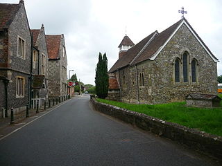
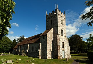
Boyton is a village and civil parish in Wiltshire, England. It lies in the Wylye Valley within Salisbury Plain, about 6 miles (10 km) south-east of Warminster and 13 miles (21 km) north-west of Salisbury. The parish includes the village of Corton.

Tisbury is a large village and civil parish approximately 13 miles (21 km) west of Salisbury in the English county of Wiltshire. With a population at the 2011 census of 2,253 it is a centre for communities around the upper River Nadder and Vale of Wardour. The parish includes the hamlets of Upper Chicksgrove and Wardour.
Bemerton, once a rural hamlet and later a civil parish to the west of Salisbury, Wiltshire, England, is now a suburb of that city. Modern-day Bemerton has areas known as Bemerton Heath, Bemerton Village and Lower Bemerton.

Edington Priory in Wiltshire, England, was founded by William Edington, the bishop of Winchester, in 1351 in his home village of Edington, about 3+3⁄4 miles (6 km) east of the town of Westbury. The priory church was consecrated in 1361 and continues in use as the parish church of Saint Mary, Saint Katharine and All Saints.
Leehurst Swan School is a co-educational independent day school in Salisbury, Wiltshire, England, for children between the ages of four and sixteen. Its site is near the city centre, about 3⁄4 mile (1.2 km) northeast of Salisbury Cathedral.

Britford is a village and civil parish beside the River Avon about 1.5 miles (2.4 km) south-east of Salisbury in Wiltshire, England. The village is just off the A338 Salisbury-Bournemouth road. The 2011 Census recorded a parish population of 592.
St Lawrence's Church at Stratford-sub-Castle is a 13th-century Grade I listed Church of England parish church, to the north of Salisbury, Wiltshire, England. It stands close to the abandoned settlement of Old Sarum and the River Avon, and is about 2 miles (3.2 km) north of Salisbury Cathedral.

St Paul's Church, Salisbury, England, is the Church of England parish church for Fisherton Anger, serving part of the northern suburbs of the city. It was consecrated in 1853 and lies north-west of the city centre, near the railway station. The congregation is affiliated to the Evangelical Alliance. The church is a Grade II listed building.

Woodford is a civil parish in southern-central Wiltshire, England, on the west bank of the Salisbury Avon, about 4 miles (6 km) north of Salisbury. Its settlements are the villages of Lower Woodford, Middle Woodford and Upper Woodford, the last of which is the largest of the three. In 1871, the population was 523; in 1951, this had decreased to 405 people.
Clarendon Park is a Grade I listed building, estate and civil parish a short distance east of the city of Salisbury in Wiltshire, England. At the 2011 census the population of the parish was 246.

The Church of St. Thomas à Becket is the Church of England parish church of Box, Wiltshire, in south-west England. It is one of a number of churches named after Thomas Becket following his martyrdom. The church has 12th-century origins and was substantially remodelled in the 14th, 15th, 18th and 19th centuries. It is a Grade I listed building.
Sir Philip Shelbourne was a British lawyer and financier.

St Osmund's Church is a Roman Catholic church in Salisbury, Wiltshire, England. It was designed by Augustus Pugin in the Gothic Revival style and built in 1847–1848. It is on Exeter Street, opposite Bishop Wordsworth's School, in the city centre. It is a Grade II listed building.

St Thomas's Church is a Church of England parish church in central Salisbury, Wiltshire, England. The church was founded in the early 13th century and rebuilt in the 15th century at the expense of the city's prosperous merchants. Above the chancel arch is a large doom painting from the late 15th century or early 16th. The building is Grade I listed.

