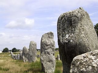
The Carnac stones are an exceptionally dense collection of megalithic sites in Brittany in northwestern France, consisting of stone alignments (rows), dolmens, tumuli and single menhirs. More than 3,000 prehistoric standing stones were hewn from local granite and erected by the pre-Celtic people of Brittany, and form the largest such collection in the world. Most of the stones are within the Breton village of Carnac, but some to the east are within La Trinité-sur-Mer. The stones were erected at some stage during the Neolithic period, probably around 3300 BCE, but some may date to as early as 4500 BCE.
Bohonagh is an axial stone circle located 2.4 km east of Rosscarbery, County Cork, Ireland. The circle is thought to date from the Bronze Age. A boulder burial is sited nearby.

Strichen Stone Circle is a small Megalithic stone circle located in the north east of Scotland, near Strichen, Aberdeenshire.
Kaffrine Department is one of the 45 departments of Senegal, and is located in the Kaffrine Region, formerly part of the Kaolack Region.
Bni Boufrah is a small town and rural commune in Al Hoceïma Province of the Tanger-Tetouan-Al Hoceima region of Morocco. At the time of the 2004 census, the commune had a total population of 10,298 people living in 1764 households.
Chakrane is a small town and rural commune in Al Hoceïma Province of the Taza-Al Hoceima-Taounate region of Morocco. At the time of the 2004 census, the commune had a total population of 6769 people living in 1004 households.
Louta is a small town and rural commune in Al Hoceïma Province of the Taza-Al Hoceima-Taounate region of Morocco. At the time of the 2004 census, the commune had a total population of 6325 people living in 1035 households.
Ketama is a small town and rural commune in Al Hoceïma Province of the Taza-Al Hoceima-Taounate region of Morocco. At the time of the 2004 census, the commune had a total population of 15,924 people living in 2,444 households.
Taghzout is a small town and rural commune in Al Hoceïma Province of the Tanger-Tétouan-Al Hoceima region of Morocco. At the time of the 2004 census, the commune had a total population of 5115 people living in 912 households.
Sidi Abdellah Ou Said is a small town and rural commune in Taroudant Province of the Souss-Massa-Drâa region of Morocco. At the time of the 2004 census, the commune had a total population of 4014 people living in 662 households.
Ait Makhlouf is a small town and rural commune in Taroudant Province of the Souss-Massa-Drâa region of Morocco. At the time of the 2004 census, the commune had a total population of 5285 people living in 1001 households.
Ain Karma is a small town and rural commune in Meknès Prefecture of the Fès-Meknès region of Morocco. At the time of the 2004 census, the commune had a total population of 9738 people living in 1674 households.
Oued Jdida is a small town and rural commune in Meknès-El Menzeh Prefecture of the Fès-Meknès region of Morocco. At the time of the 2004 census, the commune had a total population of 13634 people living in 2309 households.
N'Zalat Bni Amar is a small town and rural commune in Meknès Prefecture of the Fès-Meknès region of Morocco. At the time of the 2004 census, the commune had a total population of 8609 people living in 1780 households.
Oulad Fares is a small town and rural commune in Settat Province of the Chaouia-Ouardigha region of Morocco. At the time of the 2004 census, the commune had a total population of 11961 people living in 1812 households.
Korimate is a small town and rural commune in Essaouira Province of the Marrakech-Tensift-Al Haouz region of Morocco. At the time of the 2004 census, the commune had a total population of 10842 people living in 1912 households.
Almis Marmoucha is a small town and rural commune in Boulemane Province of the Fès-Meknès region of Morocco. At the time of the 2004 census, the commune had a total population of 2698 people living in 445 households.
Serghina is a small town and rural commune in Boulemane Province of the Fès-Meknès region of Morocco. At the time of the 2004 census, the commune had a total population of 3726 people living in 733 households.
Oulad Khallouf is a small town and rural commune in El Kelâat Es-Sraghna Province of the Marrakesh-Tensift-El Haouz region of Morocco. At the time of the 2004 census, the commune had a total population of 8064 people living in 1249 households.
Ratba is a commune in the Taounate Province of the Taza-Al Hoceima-Taounate administrative region of Morocco. At the time of the 2004 census, the commune had a total population of 15744 people living in 2950 households.
