Janowiec is a village in Puławy County, Lublin Voivodeship, in eastern Poland. It is the seat of the gmina called Gmina Janowiec. It lies approximately 12 kilometres (7 mi) south-west of Puławy and 49 km (30 mi) west of the regional capital Lublin. The village has a population of 1,000.

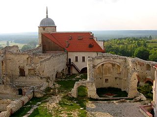
Bochotnica is a village in the administrative district of Gmina Kazimierz Dolny, within Puławy County, Lublin Voivodeship, in eastern Poland. It lies in historic province of Lesser Poland, approximately 3 kilometres (2 mi) north-east of Kazimierz Dolny, 10 km (6 mi) south of Puławy, and 42 km (26 mi) west of the regional capital Lublin. The village has a population of 1,000, and is located on the right bank of the Vistula, on the road between Puławy and Kazimierz Dolny. The ruins of a 14th-century castle are located nearby.

Wojszyn is a village in the administrative district of Gmina Janowiec, within Puławy County, Lublin Voivodeship, in eastern Poland. It lies approximately 5 kilometres (3 mi) north-east of Janowiec, 8 km (5 mi) south of Puławy, and 46 km (29 mi) west of the regional capital Lublin.
Oblasy is a village in the administrative district of Gmina Janowiec, within Puławy County, Lublin Voivodeship, in eastern Poland. It lies approximately 2 kilometres (1 mi) north-east of Janowiec, 10 km (6 mi) south-west of Puławy, and 48 km (30 mi) west of the regional capital Lublin.
Trzcianki is a village in the administrative district of Gmina Janowiec, within Puławy County, Lublin Voivodeship, in eastern Poland. It lies approximately 7 kilometres (4 mi) north of Janowiec, 6 km (4 mi) south-west of Puławy, and 48 km (30 mi) west of the regional capital Lublin.
Wierzchoniów is a village in the administrative district of Gmina Kazimierz Dolny, within Puławy County, Lublin Voivodeship, in eastern Poland. It lies approximately 7 kilometres (4 mi) east of Kazimierz Dolny, 11 km (7 mi) south-east of Puławy, and 39 km (24 mi) west of the regional capital Lublin.
Szumów is a village in the administrative district of Gmina Kurów, within Puławy County, Lublin Voivodeship, in eastern Poland. It lies approximately 8 kilometres (5 mi) south of Kurów, 18 km (11 mi) south-east of Puławy, and 29 km (18 mi) west of the regional capital Lublin.
Anielin is a village in the administrative district of Gmina Puławy, within Puławy County, Lublin Voivodeship, in eastern Poland. It lies approximately 10 kilometres (6 mi) west of Puławy and 55 km (34 mi) west of the regional capital Lublin.
Bronowice is a village in the administrative district of Gmina Puławy, within Puławy County, Lublin Voivodeship, in eastern Poland. It lies approximately 6 kilometres (4 mi) north-west of Puławy and 51 km (32 mi) north-west of the regional capital Lublin.
Janów is a village in the administrative district of Gmina Puławy, within Puławy County, Lublin Voivodeship, in eastern Poland. It lies approximately 8 kilometres (5 mi) west of Puławy and 54 km (34 mi) west of the regional capital Lublin.
Kochanów is a village in the administrative district of Gmina Puławy, within Puławy County, Lublin Voivodeship, in eastern Poland. It lies approximately 9 kilometres (6 mi) west of Puławy and 53 km (33 mi) west of the regional capital Lublin.
Leokadiów is a village in the administrative district of Gmina Puławy, within Puławy County, Lublin Voivodeship, in eastern Poland. It lies approximately 11 kilometres (7 mi) west of Puławy and 56 km (35 mi) west of the regional capital Lublin.
Pachnowola is a village in the administrative district of Gmina Puławy, within Puławy County, Lublin Voivodeship, in eastern Poland. It lies approximately 5 kilometres (3 mi) west of Puławy and 51 km (32 mi) west of the regional capital Lublin.
Piskorów is a village in the administrative district of Gmina Puławy, within Puławy County, Lublin Voivodeship, in eastern Poland. It lies approximately 11 kilometres (7 mi) west of Puławy and 56 km (35 mi) west of the regional capital Lublin.
Smogorzów is a village in the administrative district of Gmina Puławy, within Puławy County, Lublin Voivodeship, in eastern Poland. It lies approximately 10 kilometres (6 mi) west of Puławy and 55 km (34 mi) west of the regional capital Lublin.
Sosnów is a village in the administrative district of Gmina Puławy, within Puławy County, Lublin Voivodeship, in eastern Poland. It lies approximately 8 kilometres (5 mi) west of Puławy and 53 km (33 mi) west of the regional capital Lublin.
Tomaszów is a village in the administrative district of Gmina Puławy, within Puławy County, Lublin Voivodeship, in eastern Poland. It lies approximately 7 kilometres (4 mi) south-west of Puławy and 51 km (32 mi) west of the regional capital Lublin.
Zarzecze is a village in the administrative district of Gmina Puławy, within Puławy County, Lublin Voivodeship, in eastern Poland. It lies approximately 9 kilometres (6 mi) west of Puławy and 54 km (34 mi) west of the regional capital Lublin.

Expressway S12 or express road S12 is a major road in Poland which has been planned to run from Piotrków Trybunalski, through Radom, Lublin and Chełm, to the border crossing with Ukraine at Dorohusk. The completed road should be about 328 km (204 mi) long. As of Summer 2018 the portion open to traffic runs from Puławy to Lublin. A separate, shorter section forming the bypass of Opoczno may become part of S12 in the future, but for now is signed as National Road 12.


