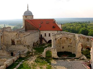
Janowiec is a village in Puławy County, Lublin Voivodeship, in eastern Poland. It is the seat of the gmina called Gmina Janowiec. It lies approximately 12 kilometres (7 mi) south-west of Puławy and 49 km (30 mi) west of the regional capital Lublin. The village has a population of 1,000.

Wojszyn is a village in the administrative district of Gmina Janowiec, within Puławy County, Lublin Voivodeship, in eastern Poland. It lies approximately 5 kilometres (3 mi) north-east of Janowiec, 8 km (5 mi) south of Puławy, and 46 km (29 mi) west of the regional capital Lublin.
Nasiłów is a village in the administrative district of Gmina Janowiec, within Puławy County, Lublin Voivodeship, in eastern Poland. It lies approximately 5 kilometres (3 mi) east of Janowiec, 10 km (6 mi) south of Puławy, and 45 km (28 mi) west of the regional capital Lublin.
Krzczeń is a village in the administrative district of Gmina Ludwin, within Łęczna County, Lublin Voivodeship, in eastern Poland. It lies approximately 6 kilometres (4 mi) north of Ludwin, 10 km (6 mi) north of Łęczna, and 29 km (18 mi) north-east of the regional capital Lublin.
Borki is a village in the administrative district of Gmina Stoczek Łukowski, within Łuków County, Lublin Voivodeship, in eastern Poland. It lies approximately 6 kilometres (4 mi) south of Stoczek Łukowski, 30 km (19 mi) west of Łuków, and 86 km (53 mi) north-west of the regional capital Lublin.
Jagodne is a village in the administrative district of Gmina Stoczek Łukowski, within Łuków County, Lublin Voivodeship, in eastern Poland. It lies approximately 7 kilometres (4 mi) south-west of Stoczek Łukowski, 33 km (21 mi) west of Łuków, and 87 km (54 mi) north-west of the regional capital Lublin.
Jamielne is a village in the administrative district of Gmina Stoczek Łukowski, within Łuków County, Lublin Voivodeship, in eastern Poland. It lies approximately 4 kilometres (2 mi) north-west of Stoczek Łukowski, 33 km (21 mi) west of Łuków, and 94 km (58 mi) north-west of the regional capital Lublin.
Januszówka is a village in the administrative district of Gmina Stoczek Łukowski, within Łuków County, Lublin Voivodeship, in eastern Poland. It lies approximately 6 kilometres (4 mi) south of Stoczek Łukowski, 28 km (17 mi) west of Łuków, and 85 km (53 mi) north-west of the regional capital Lublin.
Oblasy is a village in the administrative district of Gmina Janowiec, within Puławy County, Lublin Voivodeship, in eastern Poland. It lies approximately 2 kilometres (1 mi) north-east of Janowiec, 10 km (6 mi) south-west of Puławy, and 48 km (30 mi) west of the regional capital Lublin.
Klementowice is a village in the administrative district of Gmina Kurów, within Puławy County, Lublin Voivodeship, in eastern Poland. It lies approximately 7 kilometres (4 mi) south-west of Kurów, 15 km (9 mi) south-east of Puławy, and 32 km (20 mi) west of the regional capital Lublin.
Kolonia Klementowice is a village in the administrative district of Gmina Kurów, within Puławy County, Lublin Voivodeship, in eastern Poland. It lies approximately 4 kilometres (2 mi) south-west of Kurów, 13 km (8 mi) east of Puławy, and 34 km (21 mi) north-west of the regional capital Lublin.
Anielin is a village in the administrative district of Gmina Puławy, within Puławy County, Lublin Voivodeship, in eastern Poland. It lies approximately 10 kilometres (6 mi) west of Puławy and 55 km (34 mi) west of the regional capital Lublin.
Bronowice is a village in the administrative district of Gmina Puławy, within Puławy County, Lublin Voivodeship, in eastern Poland. It lies approximately 6 kilometres (4 mi) north-west of Puławy and 51 km (32 mi) north-west of the regional capital Lublin.
Kajetanów is a village in the administrative district of Gmina Puławy, within Puławy County, Lublin Voivodeship, in eastern Poland. It lies approximately 7 kilometres (4 mi) west of Puławy and 53 km (33 mi) north-west of the regional capital Lublin.
Klikawa is a village in the administrative district of Gmina Puławy, within Puławy County, Lublin Voivodeship, in eastern Poland. It lies approximately 4 kilometres (2 mi) west of Puławy and 50 km (31 mi) west of the regional capital Lublin.
Kochanów is a village in the administrative district of Gmina Puławy, within Puławy County, Lublin Voivodeship, in eastern Poland. It lies approximately 9 kilometres (6 mi) west of Puławy and 53 km (33 mi) west of the regional capital Lublin.
Tomaszów is a village in the administrative district of Gmina Puławy, within Puławy County, Lublin Voivodeship, in eastern Poland. It lies approximately 7 kilometres (4 mi) south-west of Puławy and 51 km (32 mi) west of the regional capital Lublin.
Zarzecze is a village in the administrative district of Gmina Puławy, within Puławy County, Lublin Voivodeship, in eastern Poland. It lies approximately 9 kilometres (6 mi) west of Puławy and 54 km (34 mi) west of the regional capital Lublin.
Wylezin is a village in the administrative district of Gmina Kłoczew, within Ryki County, Lublin Voivodeship, in eastern Poland. It lies approximately 4 kilometres (2 mi) west of Kłoczew, 10 km (6 mi) north of Ryki, and 69 km (43 mi) north-west of the regional capital Lublin.
Zaryte is a village in the administrative district of Gmina Kłoczew, within Ryki County, Lublin Voivodeship, in eastern Poland. It lies approximately 4 kilometres (2 mi) west of Kłoczew, 12 km (7 mi) north of Ryki, and 71 km (44 mi) north-west of the regional capital Lublin.


