Navtex

Last updated
A NAVTEX receiver prints an incoming message Navtex.jpg
A NAVTEX receiver prints an incoming message
NAVTEX message for the Baltic Sea Navtex Ostsee.png
NAVTEX message for the Baltic Sea

NAVTEX (NAVigational TEleX), sometimes styled Navtex or NavTex, [1] is an international automated medium frequency direct-printing service for delivery of navigational and meteorological warnings and forecasts, as well as urgent maritime safety information (MSI) to ships.

Medium frequency The range 300-3000 kHz of the electromagnetic spectrum

Medium frequency (MF) is the ITU designation for radio frequencies (RF) in the range of 300 kilohertz (kHz) to 3 megahertz (MHz). Part of this band is the medium wave (MW) AM broadcast band. The MF band is also known as the hectometer band as the wavelengths range from ten to one hectometer. Frequencies immediately below MF are denoted low frequency (LF), while the first band of higher frequencies is known as high frequency (HF). MF is mostly used for AM radio broadcasting, navigational radio beacons, maritime ship-to-shore communication, and transoceanic air traffic control.

Contents

NAVTEX was developed to provide a low-cost, simple, and automated means of receiving this information aboard ships at sea within approximately 370 km (200 nautical miles) off shore.

There are no user fees associated with receiving NAVTEX broadcasts, as the transmissions are typically transmitted from the National Weather Authority (Italy) or Navy or Coast Guard (as in the US) or national navigation authority (Canada).

Where the messages contain weather forecasts, an abbreviated format very similar to the shipping forecast is used.

NAVTEX is a component of the International Maritime Organization/International Hydrographic Organization Worldwide Navigation Warning Service (WWNWS). NAVTEX is also a major element of the Global Maritime Distress Safety System (GMDSS). SOLAS Convention mandated certain classes of vessels must carry NAVTEX, beginning August 1, 1993.

International Maritime Organization Specialised agency of the United Nations

The International Maritime Organization (IMO), known as the Inter-Governmental Maritime Consultative Organization (IMCO) until 1982, is a specialised agency of the United Nations responsible for regulating shipping. The IMO was established following agreement at a UN conference held in Geneva in 1948 and the IMO came into existence ten years later, meeting for the first time in 1959. Headquartered in London, United Kingdom, the IMO currently has 174 member states and three associate members.

International Hydrographic Organization Intergovernmental organization

The International Hydrographic Organization (IHO) is an inter-governmental organisation representing hydrography.

The International Convention for the Safety of Life at Sea (SOLAS) is an international maritime treaty which sets minimum safety standards in the construction, equipment and operation of merchant ships. The convention requires signatory flag states to ensure that ships flagged by them comply with at least these standards.

Technical information

NAVTEX transmissions are also called narrow-band direct printing (NBDP). The transmissions are layered on top of SITOR collective B-mode. SITOR-B is a forward error correcting (FEC) broadcast that uses the CCIR 476 character set. NAVTEX messages are transmitted at 100 baud using FSK modulation with a frequency shift of 170 Hz.

SITOR is a system for transmitting text messages. Although it uses the same frequency-shift keying (FSK) modulation used by regular radioteletype (RTTY), SITOR uses error detection, redundancy, and/or retransmission to improve reliability.

In telecommunication, information theory, and coding theory, forward error correction (FEC) or channel coding is a technique used for controlling errors in data transmission over unreliable or noisy communication channels. The central idea is the sender encodes the message in a redundant way by using an error-correcting code (ECC).

NAVTEX broadcasts are primarily made on the medium frequencies of 518 kHz and 490 kHz. The international NAVTEX frequency is 518 kHz, [2] and these broadcasts should always be in English. National transmission of NAVTEX, where supported, uses 490 kHz specifically for broadcasts in local languages.

NAVTEX Marine Safety Information (MSI) national transmissions also take place on HF at 4209.5 kHz using FEC mode.

High frequency The range 3-30 MHz of the electromagnetic spectrum

High frequency (HF) is the ITU designation for the range of radio frequency electromagnetic waves between 3 to 30 megahertz (MHz). It is also known as the decameter band or decameter wave as its wavelengths range from one to ten decameters. Frequencies immediately below HF are denoted medium frequency (MF), while the next band of higher frequencies is known as the very high frequency (VHF) band. The HF band is a major part of the shortwave band of frequencies, so communication at these frequencies is often called shortwave radio. Because radio waves in this band can be reflected back to Earth by the ionosphere layer in the atmosphere – a method known as "skip" or "skywave" propagation – these frequencies are suitable for long-distance communication across intercontinental distances and for mountainous terrains which prevent line-of-sight communications. The band is used by international shortwave broadcasting stations (2.31–25.82 MHz), aviation communication, government time stations, weather stations, amateur radio and citizens band services, among other uses.

NAVTEX messages are transmitted using binary frequency-shift keying (BFSK) at 100 bit/s and a 170 Hz frequency shift. The characters are encoded using the 7-bit CCIR 476 character set and basic error detection is enabled by employing forward error correction (FEC). This is the same format as the SITOR-B format.

A NAVTEX message is built on SITOR collective B-mode and consists of: [3]

  • 5 or more seconds of phasing signal and another message starting with "ZCZC" or
  • an end of emission idle signal α for at least 2 seconds.

B1 is an alpha character identifying the station, and B2 is an alpha character used to identify the subject of the message. Receivers use these characters to reject messages from certain stations or if the message contains subjects of no interest to the user.

B3 and B4 are two-digit numerics identifying individual messages, used by receivers to keep already received messages from being repeated.

For example, a message containing B1B2B3B4 characters of 'FE01' from a U.S. NAVTEX station indicates a weather forecast message from Boston, MA.

NAVTEX message example:

(phasing signals >= 10 seconds) ZCZC FE01 (message text ...) NNNN  (end of message phasing signals for >= 2 seconds before next message) 

Start of message

ZCZC begins the message.

Transmitter identity (B1)

This character defines the transmitter identity and its associated coverage area.

Subject indicator character (B2)

The subject indicator character is used by the receiver to identify different classes of messages below. The indicator is also used to reject messages concerning certain optional subjects which are not required by the ship (e.g. LORAN C messages might be rejected in a ship which is not fitted with a LORAN C receiver).

NAVTEX broadcasts use following subject indicator characters:

ANavigational warnings 1
BMeteorological warnings 1
CIce reports
DSearch & rescue information, and pirate warnings 1
EMeteorological forecasts
FPilot service messages
G AIS messages (formerly Decca messages [4] )
H LORAN messages
INot used (formerly OMEGA messages [4] )
JSATNAV messages (i.e. GPS or GLONASS)
KOther electronic navaid messages
LNavigational warnings — additional to letter A (Should not be rejected by the receiver)
TTest transmissions (UK only — not official)
VNotice to fishermen (U.S. only — currently not used)
WEnvironmental (U.S. only — currently not used)
XSpecial services — allocation by IMO NAVTEX Panel
YSpecial services — allocation by IMO NAVTEX Panel
ZNo message on hand

Note: Receivers use the B2 character to identify messages which, because of their importance, can not be rejected (designated by a 1). The subject indicator characters B, F and G are normally not used in the United States since the National Weather Service normally includes meteorological warnings in forecast messages. Meteorological warnings are broadcast using the subject indicator character E. U.S. Coast Guard District Broadcast Notices to Mariners affecting ships outside the line of demarcation, and inside the line of demarcation in areas where deep draft vessels operate, use the subject indicator character A.

Serial number of message (B3, B4)

These two characters define the serial number of each B2 message type (class). Generally serial numbers start with the numbers '01', however in special circumstances, the numbers begin with '00'. This forces the receiver to print the message.

Time of origin

Time of origin is in the format of "DDHHmm UTC MMM" where DD is the date, HH hour, mm minute and MMM three-character abbreviation of month. The time of the transmission of the message is in UTC.

Message text

The full text of the message follows.

End of message

The end of the message is asserted when the characters "NNNN" are received.

Each station identifier has a fixed 10-minute time slot, starting with A at 0000UTC. The time slots are repeated at 4 hour intervals. Within each time slot, a mix of navigation warnings, weather forecasts, ice information and other content may be sent, and this is normally according to a structured plan for that specific station. For example, in the first and third time slot they may decide to transmit navigation warnings, and weather forecasts in the others. Normally each NAVAREA or sub-NAVAREA has only one station at each slot.

Details of all transmitting stations and their schedules may be found at www.pcnavtex.com [ permanent dead link ]

NAVTEX receivers which are approved for GMDSS contain an internal printer and/or a scrollable display, and cost between $800–$1500. A new generation of NAVTEX receivers intended for non-GMDSS applications such as the recreational community is entering the marketplace. These receivers include features such as LCD screens and RS-232 output and have a purchase price in the $300–$500 range. In the UK they can be purchased for £115. There are also a number of NAVTEX engines available that do not have any user interface, and just output decoded data in RS-232 format, either as a simple ASCII data stream, or using the NMEA NAVTEX sentences, or their own proprietary protocol.

There are also a number of software packages available, such as SeaTTY, Mscan, JNX, Fldigi or JVComm32, allowing messages to be decoded by a PC with a suitable receiver connected to the computer's soundcard. Any general communications receiver capable of audio reception at 518 kHz or 490 kHz single sideband can be used.

Some organisations have gateways through which web users can access the NAVTEX bulletins using a browser:

Media

See also

Related Research Articles

Longwave radio broadcast band

In radio, longwave, long wave or long-wave, and commonly abbreviated LW, refers to parts of the radio spectrum with wavelengths longer than what was originally called the medium-wave broadcasting band. The term is historic, dating from the early 20th century, when the radio spectrum was considered to consist of longwave (LW), medium-wave (MW), and short-wave (SW) radio bands. Most modern radio systems and devices use wavelengths which would then have been considered 'ultra-short'.

Specific Area Message Encoding (SAME) is the protocol used to encode the Emergency Alert System (EAS) and NOAA Weather Radio (NWR) in the U.S. and Weatheradio Canada in Canada. It is also used to set off receivers in Mexico City and surrounding areas as part of the Mexican Seismic Alert System (SASMEX).

NOAA Weather Radio 24-hour network of VHF FM weather radio stations in the United States

NOAA Weather Radio is an automated 24-hour network of VHF FM weather radio stations in the United States that broadcast weather information directly from a nearby National Weather Service office. The routine programming cycle includes local or regional weather forecasts, synopsis, climate summaries, synopsis or zone/lake/coastal waters forecasts. During severe conditions the cycle is shortened into: hazardous weather outlooks, short-term forecasts, special weather statements or tropical weather summaries. It occasionally broadcasts other non-weather related events such as national security statements, natural disaster information, environmental and public safety statements sourced from the Federal Communications Commission's (FCC) Emergency Alert System. NOAA Weather Radio uses automated broadcast technology that allows for the recycling of segments featured in one broadcast cycle seamlessly into another and more regular updating of segments to each of the transmitters. It also speeds up the warning transmitting process.

WWV (radio station) Shortwave radio station broadcasting time signals

WWV is a shortwave radio station, located near Fort Collins, Colorado. It is best known for its continuous time signal broadcasts begun in 1945, and is also used to establish official United States government frequency standards, with transmitters operating on 2.5, 5, 10, 15, and 20 MHz. WWV is operated by U.S. National Institute of Standards and Technology (NIST), under the oversight of its Time and Frequency Division, which is part of NIST's Physical Measurement Laboratory based in Gaithersburg, Maryland.

DCF77 German longwave time signal and standard-frequency radio station

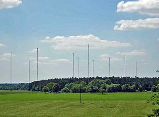
DCF77 is a German longwave time signal and standard-frequency radio station. It started service as a standard-frequency station on 1 January 1959. In June 1973 date and time information was added. Its primary and backup transmitter are located at 50°0′56″N9°00′39″E in Mainflingen, about 25 km south-east of Frankfurt am Main, Germany. The transmitter generates a nominal power of 50 kW, of which about 30 to 35 kW can be radiated via a T-antenna.

Marine VHF radio Radios operating in the very high frequency maritime mobile band

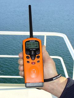
Marine VHF radio refers to the radio frequency range between 156 and 174 MHz, inclusive. The "VHF" signifies the very high frequency of the range. In the official language of the International Telecommunication Union the band is called the VHF maritime mobile band. In some countries additional channels are used, such as the L and F channels for leisure and fishing vessels in the Nordic countries.

The Global Maritime Distress and Safety System (GMDSS) is an internationally agreed-upon set of safety procedures, types of equipment, and communication protocols used to increase safety and make it easier to rescue distressed ships, boats and aircraft.

Digital selective calling

Digital selective calling or DSC is a standard for transmitting pre-defined digital messages via the medium-frequency (MF), high-frequency (HF) and very-high-frequency (VHF) maritime radio systems. It is a core part of the Global Maritime Distress Safety System (GMDSS).

Radiofax analogue mode for transmitting monochrome images

Radiofax, also known as weatherfax and HF fax, is an analogue mode for transmitting monochrome images. It was the predecessor to slow-scan television (SSTV). Prior to the advent of the commercial telephone line "fax" machine, it was known, more traditionally, by the term "radiofacsimile". The cover of the regular NOAA publication on frequencies and schedules states "Worldwide Marine Radiofacsimile Broadcast Schedules".

The radio frequency of 500 kilohertz (500 kHz) has been an international calling and distress frequency for Morse code maritime communication since early in the 20th century. The unit kilohertz was not introduced until the 1960s. For most of its history, the international distress frequency was referred to by its equivalent wavelength, 600 meters, or, using the earlier frequency unit name, 500 kilocycles or 500 kc.

Automatic identification system

The automatic identification system (AIS) is an automatic tracking system that uses transponders on ships and is used by vessel traffic services (VTS). When satellites are used to detect AIS signatures, the term Satellite-AIS (S-AIS) is used. AIS information supplements marine radar, which continues to be the primary method of collision avoidance for water transport.

Weather radio

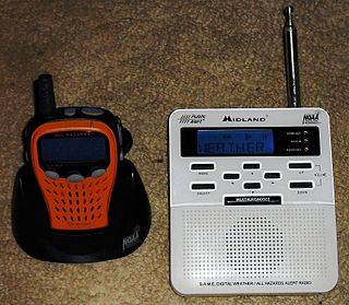
A weather radio is a specialized radio receiver that is designed to receive a public broadcast service, typically from government-owned radio stations, dedicated to airing weather reports on a continual basis, with the routine weather reports being interrupted by emergency weather reports whenever needed. Weather radios are typically equipped with a standby alerting function—if the radio is muted or tuned to another band and a severe weather bulletin is transmitted, it can automatically sound an alarm and/or switch to a pre-tuned weather channel for emergency weather information.

The radio frequency 2182 kHz is one of the international calling and distress frequencies for maritime radiocommunication in a frequency band allocated to the mobile service on primary basis, exclusively for distress and calling operations.

Weatheradio Canada is a Canadian weather radio network that is owned and operated by Environment and Climate Change Canada's Meteorological Service of Canada division. The network transmits in both official languages from 230 sites across Canada. Weatheradio Canada like their telephone service, uses the Starcaster Text to Speech, which has been used for many years and is owned by STR-SpeechTech Ltd.

This is a list of the acronyms and abbreviations used in avionics.

NAA (Arlington, Virginia) former radio station in Arlington, Virginia, United States

NAA was a major radio facility, located in Arlington, Virginia from 1913 until 1941 and operated by the United States Navy. The station was originally constructed as the first link in a network of high-powered transmitters used for international communication. During its years of operation NAA was best known for broadcasting daily time signals, however, it also provided a variety of additional services, using multiple transmitters operating on frequencies ranging from longwave to shortwave. The station also conducted extensive experimental work, including, in 1915, the first transatlantic transmission of speech.

References

  1. "NAVTEX Maritime Safety Broadcasts". www.navcen.uscg.gov. US Coast Guard.
  2. The mark frequency is 517.915 kHz, and the space frequency is 518.085 kHz.
  3. ITU R M 540-2, page 3
  4. 1 2 Fastnet Radio GMDSS Marine Radio Decoder FMD25 Manual p. 5-3

NAVTEX control and monitoring Systems

NAVTEX decoders

NAVTEX station lists & information