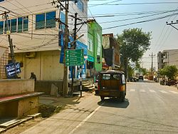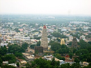
Mangalagiri is a model town in Guntur district situated between the twin cities of Vijayawada and Guntur of the Indian state of Andhra Pradesh. It is a major suburb region of the cities of Vijayawada and Guntur. It is currently the 31st most populous city of Andhra Pradesh. The town is the headquarters of Mangalagiri mandal under Guntur revenue division. It is situated on National Highway 16 between Vijayawada and Guntur. The town was known to have existed since 225 B.C..

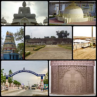
Tenali is a city in Guntur district of the Indian state of Andhra Pradesh. It is a municipality and the headquarters of Tenali mandal and Tenali revenue division. The city is renowned for art, culture, drama and hence, it is often referred with the nickname Andhra Paris. It is one of the twelve urban local bodies in Andhra Pradesh Capital Region and the twelfth most populous city in the state, with a population of 199,345 as of 2011. Tenali City is also part of Andhra Pradesh Capital Region Development Authority (APCRDA).
Amaravathi is a village on the banks of the Krishna River, in the Guntur district of the Indian state of Andhra Pradesh. It is the headquarters of Amaravathi mandal, and forms part of the Andhra Pradesh Capital Region with its headquarters at new Amaravati 35 km (22 mi) east, whose name is also borrowed from that of the older Amaravathi.

Thulluru is a neighbourhood and a part of Urban Notified Area of Amaravati, the state capital of the Indian state of Andhra Pradesh. It is located at a distance of 4 km from Krishna River and was a village in Thulluru mandal of Guntur district, prior to its denotification as gram panchayat.

Tadepalle is a town in Guntur district of the Indian state of Andhra Pradesh. The town is the headquarters of Tadepalle mandal part of Mangalagiri Tadepalle Municipal Corporation part of Guntur revenue division and is a major suburb of Vijayawada. It also forms a part of Andhra Pradesh Capital Region.

Pedavadlapudi is a village in Guntur district of the Indian state of Andhra Pradesh. It is located in Mangalagiri mandal part of Mangalagiri Tadepalle Municipal Corporation part of Guntur revenue division.

Anantavaram is a neighbourhood and a part of Urban Notified Area of Amaravati, the state capital of the Indian state of Andhra Pradesh. It was a village in Thullur mandal of Guntur district, prior to its denotification as gram panchayat.

Mangalagiri mandal is one of the 57 mandals in Guntur district of the Indian state of Andhra Pradesh. It is under the administration of Guntur revenue division and the headquarters are located at Mangalagiri town part of Mangalagiri Tadepalle Municipal Corporation. The mandal is bounded by Thullur, Tadepalle, Tadikonda, Pedakakani and Duggirala mandals and a portion of the mandal lies on the banks of Krishna River.
Tadepalle mandal is one of the 57 mandals in Guntur district of the Indian state of Andhra Pradesh. It is under the administration of Guntur Revenue Division and the headquarters are located at Tadepalle town. The mandal is situated on the banks of Krishna River, bounded by Thullur and Mangalagiri mandals. from the mandal are under the jurisdiction of Andhra Pradesh Capital City.
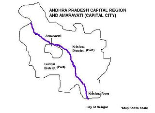
Andhra Pradesh Capital Region is the metropolitan region area surrounding Amaravati, the defacto capital city of Andhra Pradesh. It includes the major ancient cities of Vijayawada, Guntur, and Tenali. Andhra Pradesh Capital Region is one of the largest populated urban areas in the world, with its suburbs Vijayawada, Guntur, and Tenali being the 3rd, 24th, 41st most densely populated cities in the world. Vijayawada is the most densely populated city in India while Guntur is 11th and Tenali is the most populated city of 14th place in Andhra Pradesh. Andhra Pradesh Capital Region is the most populated metropolitan area in the state of Andhra Pradesh and 8th in India. Entire region is under the jurisdiction of Andhra Pradesh Capital Region Development Authority, and covers an area of 8,603 km2 (3,322 sq mi) under 58 mandals, of which 29 are in Krishna district and 29 in Guntur district. The capital region covers 18 mandals fully and 11 mandals partially in Guntur district. In Krishna district, it covers 15 mandals fully and 14 mandals partially under the jurisdiction of APCRDA. The capital city is an Urban Notified Area, and will cover 217.23 km2 (83.87 sq mi), within the Andhra Pradesh Capital Region. As of 1, August 2020, Andhra Pradesh proposed three capitals, which are Visakhapatnam as the executive capital, Amaravati as the legislative capital, and Kurnool as the judicial capital but the process is put on hold by High court and extended status quo till further orders.

Thullur mandal is one of the 57 mandals in Guntur district of the Indian state of Andhra Pradesh. It is under the administration of Guntur Revenue Division and the headquarters are located at Thullur. The mandal is situated on the banks of Krishna River, bounded by Amaravathi, Tadikonda, Tadepalle and Mangalagiri mandals. The mandal is also a part of the new capital city of Andhra Pradesh to be developed. 18 villages from the mandal fall under the jurisdiction of Andhra Pradesh Capital City.

Amaravati is a proposed city and the capital of the Indian state of Andhra Pradesh. The city is located on the banks of river Krishna in Guntur District.

Krishnayapalem is a neighbourhood of Amaravati, the state capital of the Indian state of Andhra Pradesh. It is a denotification as gram panchayat in Mangalagiri mandal of Guntur district.

Borupalem is a neighbourhood and a part of Urban Notified Area of Amaravati, the state capital of the Indian state of Andhra Pradesh. It was a village in Thullur mandal of in Guntur district, prior to its denotification as gram panchayat.
Lingayapalem is a neighbourhood and a part of Urban Notified Area of Amaravati, the state capital of the Indian state of Andhra Pradesh. It was a village in Thullur mandal of in Guntur district, prior to its denotification as gram panchayat.
Nelapadu is a neighbourhood and a part of Urban Notified Area of Amaravati, the state capital of the Indian state of Andhra Pradesh. It was a village in Thullur mandal of in Guntur district, prior to its denotification as gram panchayat.
Abbarajupalem is a neighbourhood and a part of Urban Notified Area of Amaravati, the state capital of the Indian state of Andhra Pradesh. It was a village in Thullur mandal of in Guntur district, prior to its denotification as gram panchayat.
Mangalagiri Tadepalli Municipal Corporation is the civic body that governs Mangalagiri and Tadepalle town's and villages in the corresponding mandals of the Mangalagiri in Guntur DT of state of Andhra Pradesh. It is the second largest municipal corporation next in line to GVMC in terms of area with 194.41 km2 (75.06 sq mi) and 2,53,875 of voters in the state of Andhra Pradesh. It is classified as important Municipal Corporation in the Capital of Andhra Pradesh.
Sakhamuru is a neighbourhood and a part of Urban Notified Area of Amaravati, the state capital of the Indian state of Andhra Pradesh. It was a village in Thullur mandal of in Guntur district, prior to its denotification as gram panchayat.
Nekkallu is a neighbourhood and a part of Urban Notified Area of Amaravati, the state capital of the Indian state of Andhra Pradesh. It was a village in Thullur mandal of in Guntur district, prior to its denotification as gram panchayat.