The Alaska Range is a relatively narrow, 400-mile-long (650 km) mountain range in the southcentral region of the U.S. state of Alaska, from Lake Clark at its southwest end to the White River in Canada's Yukon Territory in the southeast. The highest mountain in North America, Denali, is in the Alaska Range. It is part of the American Cordillera.

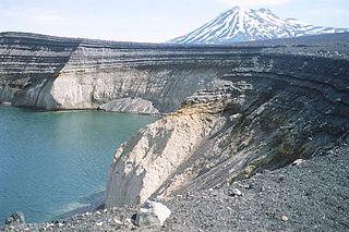
The Aleutian Range is a major mountain range located in southwest Alaska. It extends from Chakachamna Lake to Unimak Island, which is at the tip of the Alaska Peninsula. It includes all of the mountains of the Peninsula. The Aleutian Range is special because of its large number of active volcanoes, which are also part of the larger Aleutian Arc. The mainland part of the range is about 600 miles (1000 km) long. The Aleutian Islands are (geologically) a partially submerged western extension of the range that stretches for another 1,600 km (1000 mi). However the official designation "Aleutian Range" includes only the mainland peaks and the peaks on Unimak Island. The range is almost entirely roadless wilderness. Katmai National Park and Preserve, a large national park within the range, must be reached by boat or plane.

Mount Stuart is a mountain in the Cascade Range, in the U.S. state of Washington. It is the second highest non-volcanic peak in the state, after Bonanza Peak and tenth-highest overall. Mount Stuart is the highest peak in the Stuart Range, and it is located in the central part of the Washington Cascades, south of Stevens Pass and east of Snoqualmie Pass in the Alpine Lakes Wilderness.

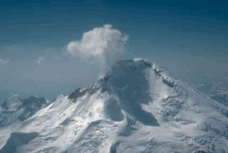
Mount Iliamna is a glacier-covered stratovolcano in the largely volcanic Aleutian Range in southwest Alaska. Located in the Chigmit Mountain subrange in Lake Clark National Park and Preserve, the 10,016-foot (3,053 m) volcano lies approximately 134 miles (215 km) southwest of Anchorage on the west side of lower Cook Inlet. It is the 25th most prominent peak in the United States.

Mount Hunter or Begguya is a mountain in Denali National Park in Alaska. It is approximately eight miles (13 km) south of Denali, the highest peak in North America. "Begguya" means child in the Dena'ina language. Mount Hunter is the third-highest major peak in the Alaska Range.

Mount Neacola is the unofficial name for the high point of the Neacola Mountains, the northernmost section of the Aleutian Range of Alaska. Despite its low elevation compared to many of the major Alaskan peaks, Mount Neacola is an impressive peak, due to its steep, pointed shape and its low base.

The Chigmit Mountains are a subrange of the Aleutian Range in the Kenai Peninsula and Lake and Peninsula Boroughs of the U.S. state of Alaska.

The Tordrillo Mountains are a small mountain range in the Matanuska-Susitna and Kenai Peninsula Boroughs in the southcentral region of the U.S. state of Alaska. They lie approximately 75 miles (120 km) west-northwest of Anchorage. The range extends approximately 60 miles (97 km) north-south and 35 miles (56 km) east-west. The highest point is Mount Torbert. On a clear day, they are easily visible from Anchorage.

Mount Chamberlin is the third highest peak in the Brooks Range, Alaska, USA. Located in what are known as the Franklin Mountains of the Brooks Range, Mount Chamberlin is 30 miles (48 km) west-northwest of Mount Isto, the tallest peak in the Brooks Range. Mount Chamberlin is within the Arctic National Wildlife Refuge and was named for Thomas Chrowder Chamberlin (1843-1928), geologist of the Peary Auxiliary Expedition of 1894. Previously believed to be the highest peak in the Brooks Range, in 2014 new measurement technology established that Mount Chamberlin is the third highest peak in the range.

The geography of the North Cascades describes a range of rugged mountains in British Columbia, Canada and Washington, United States. In Canada, the range is officially named the Cascade Mountains but is commonly referred to as the Canadian Cascades.

Mount Spickard is a 8,980-foot (2,740 m) mountain peak in the North Cascades, a mountain range in the U.S. state of Washington. Located just 2 miles (3.2 km) south of the Canada–US border, it is part of the Chilliwack Group, a subrange of the Skagit Range which is part of the North Cascades. It is composed mainly of gneiss and is part of two major drainage basins: that of the Skagit River and Fraser River.

Black Peak is a prominent 6,385-foot (1,946-meter) glaciated mountain summit located in Lake Clark National Park and Preserve, in the Chigmit Mountains of the Aleutian Range, in the US state of Alaska. It is the second-highest non-volcanic peak in the Chigmit Mountains, and fourth-highest overall. The mountain is situated 22 mi (35 km) west of Cook Inlet, 90 mi (145 km) west-southwest of Anchorage, and 10.2 mi (16 km) northeast of Double Peak, which is the nearest higher peak. Although modest in elevation, relief is significant since the mountain rises up 6,200 feet from North Fork Big River in about two miles. The mountain's descriptive name was published in 1912 by the United States Coast and Geodetic Survey. The months May through June offer the most favorable weather for viewing or climbing the peak.


