Nebraska Highway 31 is a highway in Nebraska. The southern terminus is near Louisville at an intersection with Nebraska Highway 50. The northern terminus is near Kennard at an intersection with U.S. Highway 30. The highway serves as a main north–south highway in the western portion of the Omaha Metro Area.

Nebraska Highway 13 is a highway in the northeastern part of the U.S. state of Nebraska that runs predominantly northwest-southeast with a south terminus east of Hadar at an intersection with U.S. Highway 81 and a north terminus two miles (3 km) south of Center, Nebraska at an intersection with Nebraska Highway 84.
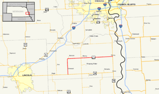
Nebraska Highway 1 (N-1) is a highway in eastern Nebraska. Its southern terminus is at U.S. Route 34 (US-34) south of Elmwood, and its eastern terminus is at US-34 and US-75 east of Murray.

Nebraska Highway 2 is a highway in Nebraska. It is a discontinuous highway with 2 segments. The western segment begins at the South Dakota border northwest of Crawford and ends southeast of Grand Island at an intersection with Interstate 80. The eastern segment begins in Lincoln and ends at the Iowa border at Nebraska City. Previously, the two segments were connected via a route shared with U.S. Highway 34 between Grand Island and Lincoln.

Nebraska Highway 4 is a highway in Nebraska. The entirety of the route is in Nebraska's southern tier of counties. Beatrice is the only city with over 1,000 in population on the highway. Its western terminus is at an intersection with US 6 and US 34 southwest of Atlanta. Its eastern terminus is at an intersection with US 75 north of Dawson.

Nebraska Highway 36 is a highway in Nebraska. Its western terminus is 0.17 miles (270 m) southwest of U.S. Highway 275 near Fremont, and its eastern terminus is at U.S. Highway 75 in Omaha.

Nebraska Highway 8 (N-8) is a highway in southern and southeastern Nebraska. Its western terminus is at Nebraska Highway 14 in Superior and its eastern terminus is at U.S. Highway 73 (US 73) in Falls City. It runs through the southern tier of counties in Nebraska and is always within 10 miles (16 km) of the Kansas border.
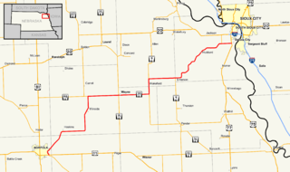
Nebraska Highway 35 is a highway in the northeastern part of the U.S. state of Nebraska. It has a western terminus in Norfolk at U.S. Highway 275 and Nebraska Highway 24 and an eastern terminus at U.S. Highway 77 and U.S. Highway 75 at Dakota City. The highway serves as a connector between Norfolk and Sioux City, Iowa.
Nebraska Highway 18 is a highway in southwestern Nebraska. It has a western terminus in Curtis at Nebraska Highway 23. Its eastern terminus is at an intersection with U.S. Highway 283 south of Elwood. The easternmost portion of the highway is a gravel road.

Nebraska Highway 21 is a highway in central Nebraska. Its southern terminus is at Nebraska Highway 23 east of Eustis. Its northern terminus is at an intersection with Nebraska Highway 2 and Nebraska Highway 92 in Broken Bow.

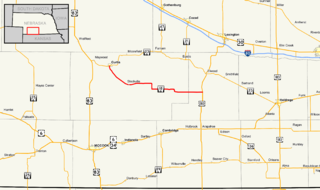
Nebraska Highway 32 is a United States highway in Nebraska. It runs for 101 miles (163 km) through east central and eastern Nebraska. Its western terminus is at Nebraska Highway 14 in Petersburg. Its eastern terminus is at U.S. Highway 75 in Tekamah.
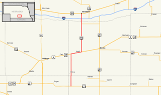
Nebraska Highway 44 is a highway in Nebraska. It runs in a south-to-north direction for 31.51 miles (50.71 km). It has a southern terminus at Nebraska Highway 4 south of Wilcox. It has a northern terminus in Kearney at an intersection with U.S. Highway 30.
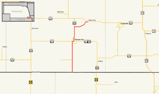
Nebraska Highway 65 is a highway in southeastern Nebraska. It is a north–south highway with a length of 15.25 miles (24.54 km). The southern terminus of Nebraska Highway 65 is at the Kansas border south of Pawnee City. The northern terminus is in Table Rock at an intersection with Nebraska Highway 4.

Nebraska Highway 59 is a highway in northeastern Nebraska. The highway is divided into two segments which combine for a length of 37.49 miles (60.33 km). The western segment of Nebraska Highway 59 has a western terminus at Nebraska Highway 14 west of Creighton and an eastern terminus at U.S. Highway 81 northeast of Magnet. The eastern segment of Highway 59 has its western terminus at Nebraska Highway 57 south of Coleridge and its eastern terminus at U.S. Highway 20 north of Laurel.

Nebraska Highway 62 is a highway in southeastern Nebraska. It is a discontinuous highway with two segments which combine for a length of 18 miles (29 km). The west terminus of the western segment of Nebraska Highway 62 is at Nebraska Highway 50 south of Tecumseh, while its eastern terminus is at Nebraska Highway 105. The west terminus of the eastern segment of Nebraska Highway 62 is at U.S. Highway 75 west of Stella, while its eastern terminus is at Nebraska Highway 67 east of Shubert.

Nebraska Highway 78 is a highway in southern Nebraska. It has a southern terminus at the Kansas border where it continues from K-28. Its northern terminus is at an intersection with Nebraska Highway 4 west of Lawrence.

Nebraska Highway 91 is a highway in central and eastern Nebraska. Its western terminus is at an intersection with Nebraska Highway 2 north of Dunning. Its eastern terminus is at an intersection with U.S. Highway 30 and U.S. Highway 75 in Blair.

Nebraska Highway 71 is a highway in western Nebraska. Its southern terminus is at the Colorado border south of Kimball, as a continuation of Colorado State Highway 71. Its northern terminus is at the South Dakota border northwest of Crawford, where it continues as South Dakota Highway 71.