Nebraska Highway 121

Last updated

N-121.svg

Nebraska Highway 121

Nebraska Highway 121 map.png

Nebraska Highway 121 highlighted in red
Route information
Maintained by NDOT
Length 55.03 mi [1] (88.56 km)
Southern segment
Length 13.51 mi [1] (21.74 km)
South endN-32.svg N-32 west of Madison
North endUS 275.svg US 275 north of Battle Creek
Middle segment
Length 28.33 mi [1] (45.59 km)
South endN-13.svg N-13 northwest of Pierce
Major
junctions
US 20.svg US 20 in Osmond
North endN-84.svg N-84 east of Bloomfield
Northern segment
Length 13.19 mi [1] (21.23 km)
South endN-12.svg N-12 west of Crofton
North endUS 81.svg US 81 northeast of Crofton
Location
Counties Southern segment: Madison
Middle segment: Pierce, Knox
Northern segment: Knox, Cedar
Highway system
N-116.svg N-116 N-128 N-128.svg

Nebraska Highway 121 is a highway in northeastern Nebraska. It is a discontinuous highway with three segments. The southern segment begins at Nebraska Highway 32 west of Madison and ends at U.S. Highway 275 north of Battle Creek. The middle segment begins at Nebraska Highway 13 northwest of Pierce and ends at Nebraska Highway 84 north of Wausa. The northern segment begins at Nebraska Highway 12 in Crofton and ends at U.S. Highway 81 northeast of Crofton, near the South Dakota border.

Nebraska State of the United States of America

Nebraska is a state that lies in both the Great Plains and the Midwestern United States. It is bordered by South Dakota to the north; Iowa to the east and Missouri to the southeast, both across the Missouri River; Kansas to the south; Colorado to the southwest; and Wyoming to the west. It is the only triply landlocked U.S. state.

Nebraska Highway 32 highway in Nebraska

Nebraska Highway 32 is a United States highway in Nebraska. It runs for 101 miles (163 km) through east central and eastern Nebraska. Its western terminus is at Nebraska Highway 14 in Petersburg. Its eastern terminus is at U.S. Highway 75 in Tekamah.

Madison, Nebraska City in Nebraska, United States

Madison is a city in and the county seat of Madison County, Nebraska, United States. The population was 2,438 at the 2010 census.

Contents

Route description

Southern segment

The southern segment of Nebraska Highway 121 begins at an intersection with NE 32 west of Madison. It heads in a northward direction through farmland, passing through Battle Creek. Just north of Battle Creek, it intersects with US 275, where this segment terminates for about 15 miles (24 km). [1] [2]

Battle Creek, Nebraska City in Nebraska, United States

Battle Creek is a city in Madison County, Nebraska, United States. It is part of the Norfolk, Nebraska Micropolitan Statistical Area. The population was 1,207 at the 2010 census.

Middle segment

The middle segment of Nebraska Highway 121 begins at NE 13 northwest of Pierce. It heads in a northward direction through farmland, where it intersects with US 20 in Osmond. NE 121 runs concurrently with US 20 for about 3.5 miles (5.6 km) to the east, before splitting and continuing northward. It then intersects NE 59 before entering Wausa to the north. The highway turns to the east and then northward again as it passes through Wausa. Further north, it will meet NE 84 and the segment will terminate at that point, resuming about 10 miles (16 km) to the northeast. [1] [3]

Nebraska Highway 13 highway in Nebraska

Nebraska Highway 13 is a highway in the northeastern part of the U.S. state of Nebraska that runs predominantly northwest-southeast with a south terminus east of Hadar at an intersection with U.S. Highway 81 and a north terminus two miles (3 km) south of Center, Nebraska at an intersection with Nebraska Highway 84.

Pierce, Nebraska City in Nebraska, United States

Pierce is a city and county seat of Pierce County, Nebraska, United States. The population was 1,767 at the 2010 census.

Osmond, Nebraska City in Nebraska, United States

Osmond is a city in Pierce County, Nebraska, United States. It is part of the Norfolk, Nebraska Micropolitan Statistical Area. The population was 783 at the 2010 census.

Northern segment

The third segment of Nebraska Highway 121 begins at NE 12 in Crofton. It heads northward from Crofton through farmland, passing by the Lewis and Clark State Recreation Area and Gavins Point Dam. At that point, the highway turns to the northeast and finally directly eastward. It meets with US 81 south of the South Dakota border and just a couple of miles south of Yankton. NE 121 terminates at US 81. [1] [4]

Nebraska Highway 12 highway in Nebraska

Nebraska Highway 12 is a highway in northern and northeastern Nebraska. It has a western terminus at U.S. Highway 83 in Valentine and an eastern terminus at U.S. Highway 20 west of Jackson. The highway largely lies within 10 miles (16 km) of the South Dakota border its entire length. The highway has been designated the Outlaw Trail Scenic Byway.

Crofton, Nebraska City in Nebraska, United States

Crofton is a city in Knox County, Nebraska, United States. The population was 726 at the 2010 census.

Gavins Point Dam

Gavins Point Dam is a 1.9 mi (3 km) long embankment rolled-earth and chalk-fill dam which spans the Missouri River and impounds Lewis and Clark Lake. The dam joins Cedar County, Nebraska with Yankton County, South Dakota a distance of 811.1 river miles upstream of St. Louis, Missouri, where the river joins the Mississippi River. The dam and hydroelectric power plant were constructed as the Gavins Point Project from 1952 to 1957 by the United States Army Corps of Engineers as part of the Pick-Sloan Plan. The dam is located approximately 4 miles west or upstream of Yankton, South Dakota.

Major intersections

CountyLocationmi [1] kmDestinationsNotes
Madison 0.000.00N-32.svg N-32 Southern end of southern segment
Battle Creek 13.5121.74US 275.svg US 275 (Front Street)Northern end of southern segment
Gap in route
Pierce 28.1345.27N-13.svg N-13 Southern end of middle segment
Osmond 36.2958.40US 20.svg US 20 west (854th Road)South end of US 20 overlap
39.5863.70US 20.svg US 20 eastNorth end of US 20 overlap
Knox 46.6175.01N-59.svg N-59
Bloomfield 56.4690.86N-84.svg N-84 Northern end of middle segment
Gap in route
Crofton 66.46106.96N-12.svg N-12 (Harold Street)Southern end of northern segment
Cedar 79.65128.18US 81.svg US 81 Northern end of northern segment
1.000 mi = 1.609 km; 1.000 km = 0.621 mi

Related Research Articles

Nebraska Highway 133 highway in Nebraska

Nebraska Highway 133 is a highway in eastern Nebraska. Its southern terminus is at an intersection with U.S. Highway 6 in Omaha. Its northern terminus is at an intersection with U.S. Highway 30 in Blair.

Nebraska Highway 67 highway in Nebraska

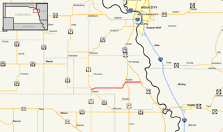
Nebraska Highway 67 is a highway in southeastern Nebraska. Its southern terminus is at an intersection with U.S. Highway 73 near Verdon. Its northern terminus is at an intersection with U.S. Highway 34 near Nehawka. The segment between Nebraska Highway 2 and US 34 is one of four segments of road in the Nebraska highway system which is gravel.

Nebraska Highway 64 highway in Nebraska

Nebraska Highway 64 is a highway in Nebraska. There are two segments to the highway. The western segment lies in Butler County between U.S. Highway 81 and Nebraska Highway 15. The eastern segment goes through Saunders and Douglas counties between U.S. Highway 77 and U.S. Highway 75.

Nebraska Highway 27 highway in Nebraska

Nebraska Highway 27 is a highway in Nebraska. It is divided into three segments. The southernmost segment begins at the Kansas border and goes north to Haigler. The middle segment begins at Interstate 80 near Chappell and goes north to Oshkosh. The northernmost segment begins at Ellsworth and goes north to the South Dakota border.

Nebraska Highway 59 highway in Nebraska

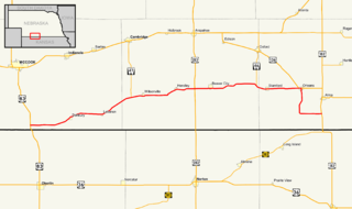
Nebraska Highway 59 is a highway in northeastern Nebraska. The highway is divided into two segments which combine for a length of 37.49 miles (60.33 km). The western segment of Nebraska Highway 59 has a western terminus at Nebraska Highway 14 west of Creighton and an eastern terminus at U.S. Highway 81 northeast of Magnet. The eastern segment of Highway 59 has its western terminus at Nebraska Highway 57 south of Coleridge and its eastern terminus at U.S. Highway 20 north of Laurel.

Nebraska Highway 69 highway in Nebraska

Nebraska Highway 69 is a highway in southeastern Nebraska. Its southern terminus is at an intersection with U.S. Highway 34 east of Waco. Its northern terminus is at an intersection with U.S. Highway 81 and Nebraska Highway 92 in Shelby.

Nebraska Highway 84 highway in Nebraska

Nebraska Highway 84 is a highway in the northeastern part of the U.S. state of Nebraska. Its western terminus is at Nebraska Highway 14 in Verdigre. Its eastern terminus is at an intersection with Nebraska Highway 15 east of Hartington.

Nebraska Highway 87 highway in Nebraska

Nebraska Highway 87 is a highway in northwestern Nebraska. It has a southern terminus at Nebraska Highway 2 in Alliance. Its northern terminus is at the South Dakota border where it continues in northward as South Dakota Highway 407.

Nebraska Highway 112 highway in Nebraska

Nebraska Highway 112 is a highway in southeastern Nebraska. Its western terminus is at the Kansas border where it continues as K-148 southwest of Odell. Its eastern terminus is at U.S. Highway 77 west of Blue Springs.

Nebraska Highway 94 highway in Nebraska

Nebraska Highway 94 is a highway in northeastern Nebraska. It has a western terminus at an intersection with Nebraska Highway 9 and Nebraska Highway 16 in Pender. Its eastern terminus is at U.S. Highway 75 to the northwest of Macy.

Nebraska Highway 97 highway in Nebraska

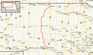
Nebraska Highway 97 is a highway in western Nebraska. It has a southern terminus north of North Platte at an intersection with U.S. Highway 83. The northern terminus is at U.S. Highway 20 in Valentine.

Nebraska Highway 89 highway in Nebraska

Nebraska Highway 89 is a highway in southern Nebraska. Its western terminus is at U.S. Highway 83 west of Danbury. Its eastern terminus is at an intersection with U.S. Highway 183 south of Alma.

Nebraska Highway 137 highway in Nebraska

Nebraska Highway 137 is a highway in northern Nebraska. Its southern terminus is at U.S. Highway 20 in Newport. Its northern terminus is at the South Dakota border where it continues as South Dakota Highway 47.

Nebraska Highway 103 highway in Nebraska

Nebraska Highway 103 is a highway in southeastern Nebraska. It is a discontinuous highway with two segments. The southern segment begins at Nebraska Highway 8 south of Diller and ends at U.S. Highway 136 north of Diller. The northern segment begins at Nebraska Highway 4 east of Plymouth and ends at Interstate 80 north of Pleasant Dale.

Nebraska Highway 105 highway in Nebraska

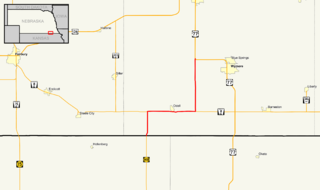
Nebraska Highway 105 is a highway in southeastern Nebraska. Its southern terminus is at an intersection with Nebraska Highway 8 south of Humboldt. Its northern terminus is at an intersection with Nebraska Highway 67 west of Brock.

Nebraska Highway 91 highway in Nebraska

Nebraska Highway 91 is a highway in central and eastern Nebraska. Its western terminus is at an intersection with Nebraska Highway 2 north of Dunning. Its eastern terminus is at an intersection with U.S. Highway 30 and U.S. Highway 75 in Blair.

Nebraska Highway 66 highway in Nebraska

Nebraska Highway 66 is a highway in central and eastern Nebraska. It is a discontinuous highway with four segments heading in a west-to-east direction. The first segment begins at Nebraska Highway 14 south of Central City and ends at U.S. Highway 81 south of Stromsburg. The second segment begins at Nebraska Highway 15 west of Dwight and ends at Nebraska Highway 79 in Valparaiso. The third segment begins at U.S. Highway 77 south of Wahoo and ends at Main Street in Louisville. The fourth and final segment begins at the intersection with Walnut Street and Koop Avenue in Louisville, and ends at U.S. Highway 34 and U.S. Highway 75 west of Plattsmouth.

Nebraska Highway 70 highway in Nebraska

Nebraska Highway 70 is a highway in central Nebraska. Its western terminus is at an intersection with Nebraska Highway 2 and Nebraska Highway 92 east of Broken Bow. Its eastern terminus is at Nebraska Highway 14 in Elgin.

Nebraska Highway 71 highway in Nebraska

Nebraska Highway 71 is a highway in western Nebraska. Its southern terminus is at the Colorado border south of Kimball, as a continuation of Colorado State Highway 71. Its northern terminus is at the South Dakota border northwest of Crawford, where it continues as South Dakota Highway 71.

Nebraska Highway 74 highway in Nebraska

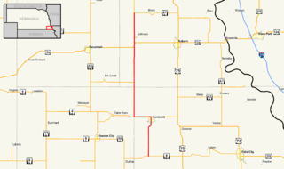
Nebraska Highway 74 is a highway in southern Nebraska. Its western terminus is at an intersection with Nebraska Highway 10 in Minden. Its eastern terminus is at an intersection with Nebraska Highway 15 east of Tobias.

References

  1. 1 2 3 4 5 6 7 8 "Nebraska Highway Reference Log Book" (PDF). Nebraska Department of Roads. 2015. pp. 267–268. Retrieved January 7, 2017.
  2. Google (2010-11-08). "overview of Nebraska Highway 121 southern segment" (Map). Google Maps . Google. Retrieved 2010-11-08.
  3. Google (2010-11-08). "overview of Nebraska Highway 121 middle segment" (Map). Google Maps . Google. Retrieved 2010-11-08.
  4. Google (2010-11-08). "overview of Nebraska Highway 121 northern segment" (Map). Google Maps . Google. Retrieved 2010-11-08.

Route map: Google

KML file (edithelp)
KML is from Wikidata