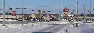
U.S. Route 275 (US 275) is a north–south United States highway. It is a branch of US 75, originally terminating at that route in Council Bluffs, Iowa. The highway's northern terminus is in O'Neill, Nebraska, at an intersection with U.S. Highway 20 and U.S. Highway 281. Its southern terminus is near Rock Port, Missouri, at an intersection with U.S. Highway 136.

Nebraska Highway 4 is a highway in Nebraska. The entirety of the route is in Nebraska's southern tier of counties. Beatrice is the only city with over 1,000 in population on the highway. Its western terminus is at an intersection with US 6 and US 34 southwest of Atlanta. Its eastern terminus is at an intersection with US 75 north of Dawson.

Nebraska Highway 67 is a highway in southeastern Nebraska. Its southern terminus is at an intersection with U.S. Highway 73 near Verdon. Its northern terminus is at an intersection with U.S. Highway 34 near Nehawka. The segment between Nebraska Highway 2 and US 34 is one of four segments of road in the Nebraska highway system which is gravel.

Nebraska Highway 14 is a highway in the U.S. state of Nebraska. It has a southern terminus at the Kansas border southwest of Superior and a northern terminus east of Niobrara at the South Dakota border.
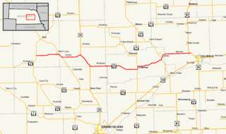
Nebraska Highway 22 is a highway in central Nebraska. It runs east–west for 89.25 miles (143.63 km). Its western terminus is at Nebraska Highway 70 south of Ord. Its eastern terminus is at U.S. Highway 81 northwest of Columbus.
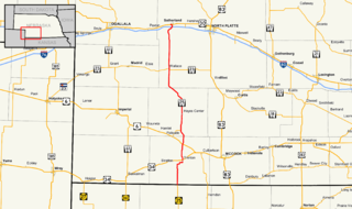
Nebraska Highway 25 is a highway in southwestern Nebraska. It runs for 87 miles (140 km). Its southern terminus is at the Kansas border south of Trenton. Its northern terminus is at U.S. Highway 30 in Sutherland.

Nebraska Highway 39 is a highway in central Nebraska. It runs for a length of 42.05 miles (67.67 km). It has a southern terminus west of Osceola at an intersection with Nebraska Highway 92. Its northern terminus is at an intersection with Nebraska Highway 14 southeast of Albion.

Nebraska Highway 41 is a highway in Nebraska. It runs for a length of 103.53 miles (166.62 km) in a west-to-east direction. Its western terminus is in Clay Center at an intersection with Nebraska Highway 14 and Nebraska Spur 18D. Its eastern terminus is at an intersection with Nebraska Highway 50 north of Tecumseh.

Nebraska Highway 52 is a highway in central Nebraska. It is 25.89 miles (41.67 km) in length and runs at a southeast-to-northwest angle, though signed north–south. The south terminus is at an intersection with Nebraska Highway 14 north of Fullerton. The northern terminus is located north of Primrose at an intersection with Nebraska Highway 91.

Nebraska Highway 84 is a highway in the northeastern part of the U.S. state of Nebraska. Its western terminus is at Nebraska Highway 14 in Verdigre. Its eastern terminus is at an intersection with Nebraska Highway 15 east of Hartington.

Nebraska Highway 87 is a highway in northwestern Nebraska. It has a southern terminus at Nebraska Highway 2 in Alliance. Its northern terminus is at the South Dakota border where it continues in northward as South Dakota Highway 407.
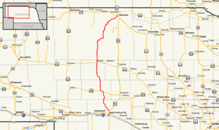
Nebraska Highway 97 is a highway in western Nebraska. It has a southern terminus north of North Platte at an intersection with U.S. Highway 83. The northern terminus is at U.S. Highway 20 in Valentine.
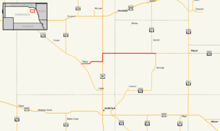
Nebraska Highway 98 is a highway in the northeastern part of the U.S. state of Nebraska. Its western terminus is at an intersection with Nebraska Highway 13 in Pierce. Its eastern terminus is at an intersection with Nebraska Highway 35 west of Wayne.

Nebraska Highway 137 is a highway in northern Nebraska. Its southern terminus is at U.S. Highway 20 in Newport. Its northern terminus is at the South Dakota border where it continues as South Dakota Highway 47.

Nebraska Highway 103 is a highway in southeastern Nebraska. It is a discontinuous highway with two segments. The southern segment begins at Nebraska Highway 8 south of Diller and ends at U.S. Highway 136 north of Diller. The northern segment begins at Nebraska Highway 4 east of Plymouth and ends at Interstate 80 north of Pleasant Dale.
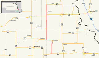
Nebraska Highway 105 is a highway in southeastern Nebraska. Its southern terminus is at an intersection with Nebraska Highway 8 south of Humboldt. Its northern terminus is at an intersection with Nebraska Highway 67 west of Brock.

Nebraska Highway 121 is a highway in northeastern Nebraska. It is a discontinuous highway with three segments. The southern segment begins at Nebraska Highway 32 west of Madison and ends at U.S. Highway 275 north of Battle Creek. The middle segment begins at Nebraska Highway 13 northwest of Pierce and ends at Nebraska Highway 84 north of Wausa. The northern segment begins at Nebraska Highway 12 in Crofton and ends at U.S. Highway 81 northeast of Crofton, near the South Dakota border.

Nebraska Highway 91 is a highway in central and eastern Nebraska. Its western terminus is at an intersection with Nebraska Highway 2 north of Dunning. Its eastern terminus is at an intersection with U.S. Highway 30 and U.S. Highway 75 in Blair.

Nebraska Highway 71 is a highway in western Nebraska. Its southern terminus is at the Colorado border south of Kimball, as a continuation of Colorado State Highway 71. Its northern terminus is at the South Dakota border northwest of Crawford, where it continues as South Dakota Highway 71.

Nebraska Highway 74 is a highway in southern Nebraska. Its western terminus is at an intersection with Nebraska Highway 10 in Minden. Its eastern terminus is at an intersection with Nebraska Highway 15 east of Tobias.


