
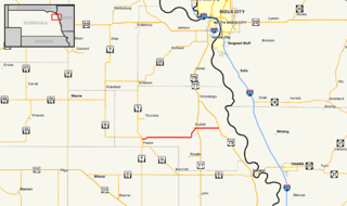
Nebraska Highway 13 is a highway in the northeastern part of the U.S. state of Nebraska that runs predominantly northwest-southeast with a south terminus east of Hadar at an intersection with U.S. Highway 81 and a north terminus two miles (3 km) south of Center, Nebraska at an intersection with Nebraska Highway 84.

Nebraska Highway 4 is a highway in Nebraska. The entirety of the route is in Nebraska's southern tier of counties. Beatrice is the only city with over 1,000 in population on the highway. Its western terminus is at an intersection with US 6 and US 34 southwest of Atlanta. Its eastern terminus is at an intersection with US 75 north of Dawson.

Nebraska Highway 8 (N-8) is a highway in southern and southeastern Nebraska. Its western terminus is at Nebraska Highway 14 in Superior and its eastern terminus is at U.S. Highway 73 (US 73) in Falls City. It runs through the southern tier of counties in Nebraska and is always within 10 miles (16 km) of the Kansas border.

Nebraska Highway 99 is a highway in southeastern Nebraska. It has a southern terminus at the Kansas border south of Burchard and just north of Summerfield, Kansas. Its northern terminus is north of Burchard at an intersection with Nebraska Highway 4. It lies entirely in Pawnee County. It is a part of a three-state "Highway 99" which includes K-99 in Kansas and Oklahoma State Highway 99.
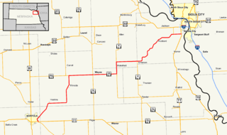
Nebraska Highway 35 is a highway in the northeastern part of the U.S. state of Nebraska. It has a western terminus in Norfolk at U.S. Highway 275 and Nebraska Highway 24 and an eastern terminus at U.S. Highway 77 and U.S. Highway 75 at Dakota City. The highway serves as a connector between Norfolk and Sioux City, Iowa.

Nebraska Highway 85 is a highway in Nebraska. It is a highway in the Omaha Metro Area. It has a southern terminus at Nebraska Highway 370 in Papillion. Its northern terminus is at U.S. Highway 275 and Nebraska Highway 92 on the border of Omaha and Ralston. It is a four-lane highway for its entire length. Most people in the Omaha area think of the highway as part of 84th Street.

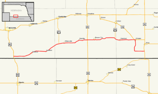
Nebraska Highway 23 is a 159.91-mile (257.35 km) highway in southwestern Nebraska, United States. Its western terminus is on the Colorado border at Venango, where the highway continues west as Colorado State Highway 23. Its eastern terminus is at Holdrege at an intersection with U.S. Highway 6 and U.S. Highway 34.

Nebraska Highway 41 is a highway in Nebraska. It runs for a length of 103.53 miles (166.62 km) in a west-to-east direction. Its western terminus is in Clay Center at an intersection with Nebraska Highway 14 and Nebraska Spur 18D. Its eastern terminus is at an intersection with Nebraska Highway 50 north of Tecumseh.

Nebraska Highway 84 is a highway in the northeastern part of the U.S. state of Nebraska. Its western terminus is at Nebraska Highway 14 in Verdigre. Its eastern terminus is at an intersection with Nebraska Highway 15 east of Hartington.

Nebraska Highway 87 is a highway in northwestern Nebraska. It has a southern terminus at Nebraska Highway 2 in Alliance. Its northern terminus is at the South Dakota border where it continues in northward as South Dakota Highway 407.

Nebraska Highway 110 is a highway in northeastern Nebraska. Its southern terminus is at Nebraska Highway 35 west of Dakota City, and its northern terminus is at U.S. Highway 20 west of South Sioux City.
Nebraska Highway 94 is a highway in northeastern Nebraska. It has a western terminus at an intersection with Nebraska Highway 9 and Nebraska Highway 16 in Pender. Its eastern terminus is at U.S. Highway 75 to the northwest of Macy.

Nebraska Highway 95 is a highway in northeastern Nebraska. It has a western terminus at an intersection with Nebraska Highway 11 west of Chambers. Its eastern terminus is at U.S. Highway 281 to the east of Chambers.

Nebraska Highway 96 is a highway in central Nebraska. It has a western terminus at an intersection with U.S. Highway 183 north of Taylor. Its eastern terminus is at Nebraska Highway 91 just to the south of Burwell.
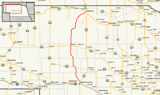
Nebraska Highway 97 is a highway in western Nebraska. It has a southern terminus north of North Platte at an intersection with U.S. Highway 83. The northern terminus is at U.S. Highway 20 in Valentine.
Nebraska Highway 89 is a highway in southern Nebraska. Its western terminus is at U.S. Highway 83 west of Danbury. Its eastern terminus is at an intersection with U.S. Highway 183 south of Alma.

Nebraska Highway 121 is a highway in northeastern Nebraska. It is a discontinuous highway with three segments:

Nebraska Highway 91 is a highway in central and eastern Nebraska. Its western terminus is at an intersection with Nebraska Highway 2 north of Dunning. Its eastern terminus is at an intersection with U.S. Highway 30 and U.S. Highway 75 in Blair.

Nebraska Highway 70 is a highway in central Nebraska. Its western terminus is at an intersection with Nebraska Highway 2 and Nebraska Highway 92 east of Broken Bow. Its eastern terminus is at Nebraska Highway 14 in Elgin.

Nebraska Highway 74 is a highway in southern Nebraska. Its western terminus is at an intersection with Nebraska Highway 10 in Minden. Its eastern terminus is at an intersection with Nebraska Highway 15 east of Tobias.

