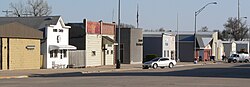
Osmond, Nebraska

Last updated

Osmond, Nebraska
Osmond, Nebraska E side State Street S from 4th.JPG
Downtown Osmond: east side of State Street, looking south from 4th Street
Pierce County Nebraska Incorporated and Unincorporated areas Osmond Highlighted.svg
Location of Osmond, Nebraska
Coordinates: 42°21′30″N97°35′56″W / 42.35833°N 97.59889°W / 42.35833; -97.59889
Country United States
State Nebraska
County Pierce
Area
[1]
  Total0.80 sq mi (2.07 km2)
  Land0.80 sq mi (2.06 km2)
  Water0.00 sq mi (0.01 km2)
Elevation
[2]
1,654 ft (504 m)
Population
 (2020) [3]
  Total791
  Estimate 
(2021)
799
  Density996.24/sq mi (384.77/km2)
Time zone UTC-6 (Central (CST))
  Summer (DST) UTC-5 (CDT)
ZIP code
68765
Area code 402
FIPS code 31-37595 [4]
GNIS feature ID2396097 [2]
Website www.ci.osmond.ne.us

Osmond is a city in Pierce County, Nebraska, United States. It is part of the Norfolk, Nebraska Micropolitan Statistical Area. The population was 791 at the 2020 census. [3]

Contents

History

Osmond was established in 1890 when the Chicago, Burlington and Quincy Railroad was extended to that point. [5] [6] It was likely named for a railroad official. [7] [8]

Geography

According to the United States Census Bureau, the city has a total area of 0.80 square miles (2.07 km2), all land. [9]

Demographics

Historical population
CensusPop.Note
1900 501
1910 56713.2%
1920 64213.2%
1930 75016.8%
1940 7966.1%
1950 732−8.0%
1960 719−1.8%
1970 88322.8%
1980 871−1.4%
1990 774−11.1%
2000 7962.8%
2010 783−1.6%
2020 7911.0%
2021 (est.)799 [3] 1.0%
U.S. Decennial Census [10]

2010 census

At the 2010 census there were 783 people in 319 households, including 215 families, in the city. The population density was 978.8 inhabitants per square mile (377.9/km2). There were 360 housing units at an average density of 450.0 per square mile (173.7/km2). The racial makup of the city was 97.8% White, 0.3% African American, 0.3% Asian, 0.5% from other races, and 1.1% from two or more races. Hispanic or Latino of any race were 1.8%. [11]

Of the 319 households 31.7% had children under the age of 18 living with them, 58.0% were married couples living together, 6.6% had a female householder with no husband present, 2.8% had a male householder with no wife present, and 32.6% were non-families. 29.5% of households were one person and 16.6% were one person aged 65 or older. The average household size was 2.40 and the average family size was 2.94.

The median age was 43.1 years. 26.7% of residents were under the age of 18; 4.5% were between the ages of 18 and 24; 21.1% were from 25 to 44; 24.5% were from 45 to 64; and 23.2% were 65 or older. The gender makeup of the city was 47.3% male and 52.7% female.

2000 census

At the 2000 census there were 796 people in 340 households, including 218 families, in the city. The population density was 1,133.4 inhabitants per square mile (437.6/km2). There were 370 housing units at an average density of 526.8 per square mile (203.4/km2). The racial makup of the city was 98.24% White, 0.13% African American, 0.25% Native American, 0.63% Asian, 0.75% from other races. Hispanic or Latino of any race were 1.26%. [4]

Of the 340 households 28.5% had children under the age of 18 living with them, 55.3% were married couples living together, 6.5% had a female householder with no husband present, and 35.6% were non-families. 33.5% of households were one person and 21.8% were one person aged 65 or older. The average household size was 2.30 and the average family size was 2.94.

The age distribution was 25.6% under the age of 18, 4.9% from 18 to 24, 22.1% from 25 to 44, 20.4% from 45 to 64, and 27.0% 65 or older. The median age was 42 years. For every 100 females, there were 90.9 males. For every 100 females age 18 and over, there were 83.9 males.

As of 2000 the median income for a household in the city was $27,120, and the median family income was $35,000. Males had a median income of $28,750 versus $17,981 for females. The per capita income for the city was $15,356. About 5.8% of families and 7.1% of the population were below the poverty line, including 9.0% of those under age 18 and 7.9% of those age 65 or over.

Related Research Articles

<span class="mw-page-title-main">Shellsburg, Iowa</span> City in Iowa, United States

Shellsburg is a city in Benton County, Iowa, United States. The population was 961 at the time of the 2020 census. It is part of the Cedar Rapids Metropolitan Statistical Area.

<span class="mw-page-title-main">Grand River, Iowa</span> City in Iowa, United States

Grand River is a city in northwest Decatur County, Iowa, United States. The population was 196 at the time of the 2020 census.

<span class="mw-page-title-main">Wyoming, Iowa</span> City in Iowa, United States

Wyoming is a city in Jones County, Iowa, United States. The population was 523 at the time of the 2020 census. It is part of the Cedar Rapids Metropolitan Statistical Area.

<span class="mw-page-title-main">Columbus City, Iowa</span> City in Iowa, United States

Columbus City is a city in western Louisa County, Iowa, United States. The population was 392 at the 2020 census. It is part of the Muscatine Micropolitan Statistical Area.

<span class="mw-page-title-main">Mallard, Iowa</span> City in Iowa, United States

Mallard is a city in Palo Alto County, Iowa, United States. The population was 257 at the time of the 2020 census.

<span class="mw-page-title-main">West Chester, Iowa</span> City in Iowa, United States

West Chester is a city in Washington County, Iowa, United States. It is part of the Iowa City, Iowa Metropolitan Statistical Area. The population was 144 at the time of the 2020 census.

<span class="mw-page-title-main">Powhattan, Kansas</span> City in Brown County, Kansas

Powhattan is a city in Brown County, Kansas, United States. As of the 2020 census, the population of the city was 69.

<span class="mw-page-title-main">Mosby, Missouri</span> City in Missouri, United States

Mosby is a city in Clay County, Missouri, United States, along the Fishing River. The population was 101 at the 2020 census. It is part of the Kansas City metropolitan area.

<span class="mw-page-title-main">Weaubleau, Missouri</span> City in Missouri, United States

Weaubleau is a city in Hickory County, Missouri, United States, founded in 1867. The population was 378 at the 2020 census.

<span class="mw-page-title-main">Levasy, Missouri</span> City in Missouri, United States

Levasy is a city in Jackson County, Missouri, United States. The population was 83 at the 2010 census. It is part of the Kansas City metropolitan area.

<span class="mw-page-title-main">Wood Heights, Missouri</span> City in Missouri, United States

Wood Heights is a city in western Ray County, Missouri, and part of the Kansas City metropolitan area within the United States. The population was 757 at the 2020 census.

<span class="mw-page-title-main">Clearwater, Nebraska</span> Village in Antelope County, Nebraska, United States

Clearwater is a village in Antelope County, Nebraska, United States. The population was 419 at the 2010 census.

<span class="mw-page-title-main">Snyder, Nebraska</span> Village in Nebraska, United States

Snyder is a village in Dodge County, Nebraska, United States. The population was 300 at the 2010 census.

<span class="mw-page-title-main">Milligan, Nebraska</span> Village in Nebraska, United States

Milligan is a village in Fillmore County, Nebraska, United States. The population was 241 at the 2020 census.

<span class="mw-page-title-main">Riverton, Nebraska</span> Village in Franklin County, Nebraska, United States

Riverton is a village in Franklin County, Nebraska, United States. The population was 89 at the 2010 census.

<span class="mw-page-title-main">Hayes Center, Nebraska</span> Village in Hayes County, Nebraska, United States

Hayes Center is a village in Hayes County, Nebraska, United States, which has served as that county's county seat since 1885. Its population, according to the 2010 U.S. census, was 214.

<span class="mw-page-title-main">Clarks, Nebraska</span> Village in Nebraska, United States

Clarks is a village in Merrick County, Nebraska, United States. The population was 344 at the 2020 census. It is part of the Grand Island, Nebraska Micropolitan Statistical Area.

<span class="mw-page-title-main">Stromsburg, Nebraska</span> City in Polk County, Nebraska, United States

Stromsburg is a city in Polk County, Nebraska, United States. The population was 1,028 as per the 2020 census.

<span class="mw-page-title-main">Whitewood, South Dakota</span> City in South Dakota, United States

Whitewood is a city in Lawrence County, South Dakota, United States. The population was 879 at the 2020 census.

<span class="mw-page-title-main">Tilden, Nebraska</span> City in Antelope and Madison counties in Nebraska, United States

Tilden is a city in Antelope and Madison counties in Nebraska, United States. The population was 953 at the 2010 census. The Madison County portion of Tilden is part of the Norfolk, Nebraska Micropolitan Statistical Area.

References

  1. "ArcGIS REST Services Directory". United States Census Bureau. Retrieved September 18, 2022.
  2. 1 2 U.S. Geological Survey Geographic Names Information System: Osmond, Nebraska
  3. 1 2 3 Bureau, US Census. "City and Town Population Totals: 2020-2021". Census.gov. US Census Bureau. Retrieved November 18, 2022.
  4. 1 2 "U.S. Census website". United States Census Bureau . Retrieved January 31, 2008.
  5. Burr, George L. (1921). History of Hamilton and Clay Counties, Nebraska, Volume 1. S.J. Clarke Publishing Company. p. 133.
  6. "Osmond, Pierce County". Center for Advanced Land Management Information Technologies. University of Nebraska. Retrieved August 22, 2014.
  7. Exploring Nebraska Highways: Trip Trivia. Exploring America's Highway. 2007. p. 110. ISBN   978-0-9744358-7-9.
  8. Fitzpatrick, Lillian L. (1960). Nebraska Place-Names. University of Nebraska Press. p. 114. ISBN   0-8032-5060-6. A 1925 edition is available for download at University of Nebraska—Lincoln Digital Commons.
  9. "US Gazetteer files 2010". United States Census Bureau. Archived from the original on January 25, 2012. Retrieved June 24, 2012.
  10. "Census of Population and Housing". Census.gov. Retrieved June 4, 2015.
  11. "U.S. Census website". United States Census Bureau . Retrieved June 24, 2012.