Needmore, Terry County, Texas

Last updated

Needmore, Texas
Needmore Texas Cotton Gin.jpg
Needmore Cotton Gin
Relief map of Texas.png
Red pog.svg
Needmore
Coordinates: 33°19′36″N102°19′36″W / 33.32667°N 102.32667°W / 33.32667; -102.32667 [1]
CountryFlag of the United States.svg  United States
StateFlag of Texas.svg  Texas
County Terry
Region Llano Estacado
Established1904
Elevation
[1]
3,415 ft (1,041 m)
Population
 (2000)
  Total35
Time zone UTC-6 (CST)
ZIP code
79316
Area code 806
Website Handbook of Texas

Needmore is a small unincorporated community in north central Terry County, Texas, United States.

Contents

History

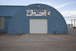
Early settlers of the region included the Beasley, Green, Brock, and Gibson families. [2] A school was established around 1904 and eventually formed one of the first four school districts in the county. [2] By the late 1960s, Needmore had a general store, a cotton gin, and a population of four. Today, only the cotton gin is still operating. In 2000, the population was 55.

Geography

Needmore lies on the high plains of the Llano Estacado at the intersection of U.S. Highway 385 and Farm to Market Road 211. The community is located 7 mi (11 km) west of Meadow, 10.5 mi (16.9 km) north of Brownfield, or 32 mi (51 km) southwest of Lubbock. It is 4 mi (6.4 km) south of the Hockley County line in north-central Terry County.

In the state of Texas, four small communities share the name Needmore and the high plains area of the Llano Estacado has two. Needmore (Bailey County) is located about 55 mi (89 km) to the northwest of Needmore (Terry County). Both are rural agricultural communities with cotton gins.

The terrain surrounding Needmore consists of level plains that at one time were covered with grassland vegetation and grazing bison. Today, the bison are gone and the shortgrass prairie has been replaced by plowed cropland, where cotton, sorghum, and winter wheat are grown. No flowing streams remain near Needmore, but a dry stream channel called Lost Draw passes to the south of the community. Numerous shallow lakes called “playas” dot the landscape surrounding Needmore. Most of these playas hold water for a short time after rain, then dry and remain dry for extended periods. Some of the larger saline playas to the southeast, such as Rich Lake and Mound Lake, provide refuge for migratory waterfowl flying between Canada and Mexico.

Education

The town of Needmore once had its own school, which became an independent district in 1929. In the early 1940s, the Needmore school was consolidated with the Meadow school. [2] Today, the town of Needmore is served by the Meadow Independent School District, home to the Meadow High School Broncos.

See also

Related Research Articles

<span class="mw-page-title-main">New Home, Texas</span> City in Texas, United States

New Home is a small city in Lynn County, Texas, United States. The population was 334 at the 2010 census.

<span class="mw-page-title-main">Llano Estacado</span> Southwestern United States in New Mexico and Texas

The Llano Estacado, sometimes translated into English as the Staked Plains, is a region in the Southwestern United States that encompasses parts of eastern New Mexico and northwestern Texas. One of the largest mesas or tablelands on the North American continent, the elevation rises from 3,000 feet (900 m) in the southeast to over 5,000 feet (1,500 m) in the northwest, sloping almost uniformly at about 10 feet per mile (2 m/km).

<span class="mw-page-title-main">Grulla National Wildlife Refuge</span> National Wildlife Refuge near Portales, New Mexico

Grulla National Wildlife Refuge is located primarily in eastern New Mexico in Roosevelt County, southwest of the intersection of State Highway 88 and the Texas - New Mexico border about 25 miles southeast of Portales, New Mexico and southeast of the tiny community of Arch. A very small part of the refuge extends eastward into western Bailey County, Texas.

<span class="mw-page-title-main">Cotton Center, Texas</span> Unincorporated community in Texas, United States

Cotton Center is an unincorporated community in western Hale County, Texas, United States, located about 12 miles southwest of Hale Center. Until the late 19th century, the Comanche tribe of Native Americans occupied the area. In 1907, with the coming of a branch of the Santa Fe Railroad, a number of farming operations were established. Cotton Center was originally created in 1925 as a consolidated school district, with a small unincorporated community site, containing the school, cotton gins, and various businesses to support the surrounding farms. In 1935, a local post office opened, and the first irrigation well was drilled. By the late 1940s, irrigation wells proliferated, pumping water from the Ogallala Aquifer. The community revolves around farming and is tied together by the school, which as of 2005 had 140 students in prekindergarten through grade 12.

<span class="mw-page-title-main">Shafter Lake, Texas</span> Ghost Town in Texas, United States

Shafter Lake is a ghost town in Andrews County, Texas, United States, located four miles west of U.S. Route 385 on the shores of a large salt playa named Shafter Lake. It became a ghost town after the town lost an election for county seat of Andrews County.

<span class="mw-page-title-main">Stiles, Texas</span> Ghost town in Texas, United States

Stiles is a ghost town in Reagan County, Texas, United States, about 18 mi (29 km) north of Big Lake. As the only town in the area when Reagan County was established in 1903, Stiles was made the county seat. Bypassed by the railroad and eclipsed when oil was discovered near Big Lake, Stiles was replaced with Big Lake as the county seat in 1925.

<span class="mw-page-title-main">White River (Texas)</span> River in Texas, United States

The White River is an intermittent stream in the South Plains of Texas and a tributary of the Brazos River of the United States. It rises 8 miles (13 km) west of Floydada in southwestern Floyd County at the confluence of Callahan and Runningwater Draws. From there, it runs southeast for 62 miles (100 km) to its mouth on the Salt Fork of the Brazos River in northwestern Kent County. Besides these two headwaters, which rise near Hale Center and in Curry County, New Mexico, respectively, other tributaries include Pete, Crawfish, and Davidson Creeks. The White River drains an area of 1,690 sq mi (4,377 km2).

<span class="mw-page-title-main">Fieldton, Texas</span> Unincorporated community in Texas, United States

Fieldton is an unincorporated community in Lamb County, Texas, United States. Fieldton has a post office with the ZIP code 79326.

<span class="mw-page-title-main">Needmore, Bailey County, Texas</span> Unincorporated community in Texas, United States

Needmore is an unincorporated community in Bailey County, Texas, United States.

<span class="mw-page-title-main">Bula, Texas</span> Unincorporated community in Texas, United States

Bula is an unincorporated community in Bailey County, Texas, United States. According to the Handbook of Texas, the community had a population of 35 in 2000.

<span class="mw-page-title-main">Double Mountain Fork Brazos River</span> River in Texas, United States

The Double Mountain Fork Brazos River is an ephemeral, sandy-braided stream about 170 mi (280 km) long, heading on the Llano Estacado of West Texas about 11.5 mi (18.5 km) southeast of Tahoka, Texas, flowing east-northeast across the western Rolling Plains to join the Salt Fork, forming the Brazos River about 18 mi (29 km) west-northwest of Haskell, Texas.

<span class="mw-page-title-main">Posey, Texas</span> Unincorporated community in Texas, United States

Posey is a small, unincorporated, community located on the level plains of the Llano Estacado about 11 mi (18 km) southeast of Lubbock in southeastern Lubbock County, Texas.

<span class="mw-page-title-main">Barwise, Texas</span> Unincorporated community in Texas, United States

Barwise is a small, unincorporated community located on the level plains of the Llano Estacado about 10 mi (16 km) west of Floydada in western Floyd County, Texas. The town was founded in 1928 after the Fort Worth and Denver South Plains Railway Company laid tracks through the area. The rail spur that passes through Barwise extended from the Fort Worth and Denver Railway junction at Estelline to Lubbock and Plainview.

<span class="mw-page-title-main">Heckville, Texas</span> Unincorporated community in Texas, United States

Heckville is an unincorporated community located on the high plains of the Llano Estacado about 16 mi (26 km) northeast of Lubbock or 7 mi (11 km) north of Idalou in northeastern Lubbock County, Texas. This small town was named after Henry Heck, who built a cotton gin to serve the community in 1948.

<span class="mw-page-title-main">Becton, Texas</span> Unincorporated community in Texas, United States

Becton is an unincorporated community in northeast Lubbock County, about 18 mi (29 km) northeast of Lubbock, Texas. This small rural community lies on the high plains of the Llano Estacado in West Texas.

<span class="mw-page-title-main">Close City, Texas</span> Unincorporated community in Texas, United States

Close City is an unincorporated community in western Garza County, about 6.5 mi (10.5 km) west-northwest of Post, Texas. The small rural community lies on the High Plains of the Llano Estacado in West Texas.

<span class="mw-page-title-main">Salt Fork Brazos River</span> River

The Salt Fork Brazos River is a braided, highly intermittent stream about 150 mi (240 km) long, heading along the edge of the Llano Estacado about 26 mi (42 km) east-southeast of Lubbock, Texas. From its source, it flows generally east-southeastward to join the Double Mountain Fork to form the Brazos River about 18 mi (29 km) west-northwest of Haskell, Texas. The Salt Fork stretches across portions of Crosby, Garza, Kent, and Stonewall counties of West Texas.

<span class="mw-page-title-main">Canyon Valley, Texas</span> Ghost town in Texas, United States

Canyon Valley is a ghost town in southern Crosby County, Texas, United States. Today, only a few farms and ranches are scattered across the area.

<span class="mw-page-title-main">Roundup, Texas</span> Unincorporated community in Texas, United States

Roundup is an unincorporated community located in northeastern Hockley County. The town is located on the high plains of the Llano Estacado at the intersection of U.S. Route 84 and Farm to Market Road 2130 between Anton and Shallowater.

The Tahoka Formation is a geological formation in Texas and New Mexico, which was emplaced in now-dry lakes during late Pleistocene wet periods.

References

  1. 1 2 "Needmore". Geographic Names Information System . United States Geological Survey, United States Department of the Interior.
  2. 1 2 3 Davis, Charles G. (November 27, 2010). "Needmore, TX (Terry County)". Handbook of Texas Online. Retrieved April 20, 2013.