The Pennsylvania Turnpike is a toll highway operated by the Pennsylvania Turnpike Commission (PTC) in the U.S. state of Pennsylvania. A controlled-access highway, it runs for 360 miles (580 km) across the state. The turnpike begins at the Ohio state line in Lawrence County, where the road continues west as the Ohio Turnpike. It ends at the New Jersey border at the Delaware River–Turnpike Toll Bridge over the Delaware River in Bucks County, where the road continues east as the Pearl Harbor Memorial Extension of the New Jersey Turnpike.

The Allegheny Portage Railroad was the first railroad constructed through the Allegheny Mountains in central Pennsylvania, United States; it operated from 1834 to 1854 as the first transportation infrastructure through the gaps of the Allegheny that connected the midwest to the eastern seaboard across the barrier range of the Allegheny Front. Approximately 36 miles (58 km) long overall, both ends connected to the Pennsylvania Canal, and the system was primarily used as a portage railway, haulting river boats and barges over the divide between the Ohio and the Susquehanna Rivers. Today, the remains of the railroad are preserved within the Allegheny Portage Railroad National Historic Site operated by the National Park Service.

Sideling Hill is a long, steep, narrow mountain ridge in the Ridge-and-Valley physiographic province of the Appalachian Mountains, located in Washington County in western Maryland and adjacent West Virginia and Pennsylvania, USA. The highest point on the ridge is Fisher Point, at 2,310 feet (700 m) in Fulton County, Pennsylvania.

The Great Allegheny Passage (GAP) is a rail trail system in Maryland and Pennsylvania—the central trail of a network of long-distance hiker-biker trails throughout the Allegheny region of the Appalachian Mountains, connecting Washington, D.C. to Pittsburgh, Pennsylvania. It consists of several smaller trails including the Allegheny Highlands Trail of Maryland, the Allegheny Highlands Trail of Pennsylvania and the Youghiogheny River Trail.
Interstate 76 (I-76) is an Interstate Highway in the Eastern United States, running about 434 miles (700 km) from an interchange with I-71 west of Akron, Ohio, east to I-295 in Bellmawr, New Jersey.
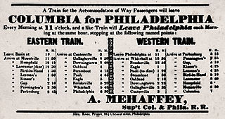
Philadelphia and Columbia Railroad (P&CR) (1834) was one of the earliest commercial railroads in the United States, running 82 miles (132 km) from Philadelphia to Columbia, Pennsylvania, it was built by the Pennsylvania Canal Commission in lieu of a canal from Columbia to Philadelphia; in 1857 it became part of the Pennsylvania Railroad. It is currently owned and operated by Amtrak as its electrified Keystone Corridor. The Philadelphia and Columbia Railroad's western terminus was located near the former ferry site known as Wright's Ferry, in the town once of that name, but now Columbia in Lancaster County. There the P&CR met with the Pennsylvania Canal—navigations and improvements on the Susquehanna River east bank approximately 30 miles (48.3 km) south of Harrisburg, Pennsylvania. Most of its right-of-way was obtained by the actions of the Pennsylvania Canal Commission which operated the railroad under the various enabling acts of the Pennsylvania legislature known as the Main Line of Public Works in support of a far sighted plan to link the whole state by canals. With an engineering study reporting back a finding that obtaining sufficient waters to flood the intended 80+ mile canal from Philadelphia to Columbia, the Canal Commission and legislature authorized the railway on the right of way intended for the canal.

Breezewood is an unincorporated town in East Providence Township, Bedford County in south-central Pennsylvania.

Sideling Hill Tunnel is one of three original Pennsylvania Turnpike tunnels abandoned after two massive realignment projects. The others are nearby Rays Hill Tunnel, and farther west, the Laurel Hill Tunnel. It was less expensive to realign the Turnpike than to bore a second tube for four lane traffic. Sideling Hill Tunnel is 6,782 feet (2,067 m) long. It was the longest of the original tunnels on the Pennsylvania Turnpike. The Ray's Hill Tunnel and Sideling Hill Tunnel are now part of the Pike2Bike Trail. Together, the two tunnels as well as the roadway are commonly known as the Abandoned Pennsylvania Turnpike.

Rays Hill Tunnel is one of three original Pennsylvania Turnpike tunnels which were abandoned after two massive realignment projects. The others included the Sideling Hill Tunnel, and farther west, the Laurel Hill Tunnel.

Laurel Hill Tunnel is one of three original tunnels on the Pennsylvania Turnpike which were abandoned after two massive realignment projects.
The South Pennsylvania Railroad is the name given to two proposed but never completed Pennsylvania railroads in the nineteenth-century. Parts of the right of way for the second South Pennsylvania Railroad were reused for the Pennsylvania Turnpike.

The Allegheny Mountain Tunnel is a vehicular tunnel carrying the Pennsylvania Turnpike through the Allegheny Mountains. At this point, the Turnpike carries Interstates 70 and 76. When the tunnel was built, it was considered an "engineering marvel."
In the U.S. state of Pennsylvania, U.S. Route 30 runs east–west across the southern part of the state, passing through Pittsburgh and Philadelphia on its way from the West Virginia state line east to the Benjamin Franklin Bridge over the Delaware River into New Jersey. In Pennsylvania, US 30 runs along or near the transcontinental Lincoln Highway, which ran from San Francisco, California to New York City before the U.S. Routes were designated.
The Abandoned Pennsylvania Turnpike is the common name of a 13-mile (21 km) stretch of the Pennsylvania Turnpike that was bypassed in 1968 when a modern stretch opened to ease traffic congestion in the tunnels. In this case, the Sideling Hill Tunnel and Rays Hill Tunnel were bypassed, as was one of the Turnpike's travel plazas. The bypass is located just east of the heavily congested Breezewood interchange for Interstate 70 (I-70) eastbound at what is now I-76 exit 161. The section of the turnpike was at one time part of the South Pennsylvania Railroad.
Buchanan State Forest is a Pennsylvania State Forest in Pennsylvania Bureau of Forestry District #2. The main office is located in McConnellsburg in Fulton County, Pennsylvania, in the United States. It is named for James Buchanan of Pennsylvania, the fifteenth President of the United States.

The Main Line of the Pennsylvania Railroad was a rail line in the Commonwealth of Pennsylvania, connecting Philadelphia with Pittsburgh via Harrisburg. The rail line was split into two rail lines and now all of its right of way is a cross-state corridor, composed of Amtrak's Philadelphia to Harrisburg Main Line and the Norfolk Southern Railway's Pittsburgh Line.
The Pittsburgh, Westmoreland, & Somerset Railroad (PW&S) was a short-lived railroad that connected the Pennsylvania communities of Ligonier and Somerset, running over a mountain known as Laurel Hill or Laurel Mountain.
The Quemahoning Tunnel is a tunnel that was constructed for use on the stillborn South Pennsylvania Railroad. The tunnel is located in Somerset County, Pennsylvania near the 106.3 milemarker of the Pennsylvania Turnpike.
The Pittsburgh Line is a rail line that is located in state of the Pennsylvania and it is owned and operated by the Norfolk Southern Railway. The Pittsburgh Line is Norfolk Southern Railway's primary east–west artery in its Pittsburgh Division and Harrisburg Division across Pennsylvania and it is part of the Amtrak-Norfolk Southern combined rail corridor, the Keystone Corridor.