The Pennsylvania Turnpike, sometimes shortened to Penna Turnpike or PA Turnpike, is a controlled-access toll road which is operated by the Pennsylvania Turnpike Commission (PTC) in Pennsylvania. It runs for 360 miles (580 km) across the state, connecting Pittsburgh and Philadelphia, and passes through four tunnels as it crosses the Appalachian Mountains. A component of the Interstate Highway System, it is part of Interstate 76 (I-76) between the Ohio state line and Valley Forge. I-70 runs concurrently with I-76 between New Stanton and Breezewood, Interstate 276 (I-276) between Valley Forge and Bristol Township, and I-95 from Bristol Township to the New Jersey state line.
Interstate 376 (I-376) is a major auxiliary route of the Interstate Highway System in the US state of Pennsylvania, located within the Allegheny Plateau. It runs from I-80 near Sharon south and east to a junction with the Pennsylvania Turnpike in Monroeville, after having crossed the Pennsylvania Turnpike at an interchange in Big Beaver. The route serves Pittsburgh and its surrounding areas and is the main access road to Pittsburgh International Airport (PIT). Portions of the route are known as the Beaver Valley Expressway, Southern Expressway, and Airport Parkway. Within Allegheny County, the route runs along the majority of the Penn-Lincoln Parkway, known locally as Parkway West and Parkway East. It is currently the ninth-longest auxiliary Interstate route in the system and second only to I-476 within Pennsylvania.

Sideling Hill, also Side Long Hill, is a long, steep, narrow mountain ridge in the Ridge-and-Valley physiographic province of the Appalachian Mountains, located in Washington County in western Maryland and adjacent West Virginia and Pennsylvania, USA. The highest point on the ridge is Fisher Point, at 2,310 feet (700 m) in Fulton County, Pennsylvania.

Interstate 76 (I-76) is an east–west Interstate Highway in the Eastern United States. The highway runs approximately 435.66 miles (701.13 km) from an interchange with I-71 west of Akron, Ohio, east to I-295 in Bellmawr, New Jersey. This route is not contiguous with I-76 in Colorado and Nebraska.
Interstate 476 (I-476) is a 132.1-mile (212.6 km) auxiliary Interstate Highway of I-76 in the U.S. state of Pennsylvania. The highway runs from I-95 near Chester north to I-81 near Scranton, serving as the primary north–south Interstate corridor through eastern Pennsylvania. It consists of both the 20-mile (32 km) Mid-County Expressway, locally referred to as the "Blue Route", through Delaware and Montgomery counties in the suburban Philadelphia area, and the tolled, 110.6-mile (178.0 km) Northeast Extension of the Pennsylvania Turnpike, which connects the Delaware Valley with the Lehigh Valley, the Pocono Mountains, and the Wyoming Valley to the north.

Breezewood is an unincorporated town in East Providence Township, Bedford County in south-central Pennsylvania, United States. Along a traditional pathway for Native Americans, European settlers, and British troops during colonial times, in the early 20th century, the small valley that became known as Breezewood was a popular stopping place for automobile travelers on the Lincoln Highway, beginning in 1913. Greyhound Lines opened a Post House facility in the town in 1935; it closed in 2004.

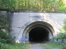
Sideling Hill Tunnel is one of three original Pennsylvania Turnpike tunnels abandoned after two massive realignment projects. The others are nearby Rays Hill Tunnel, and farther west, the Laurel Hill Tunnel. It was less expensive to realign the Turnpike than to bore a second tube for four lane traffic. Sideling Hill Tunnel is 6,782 feet (2,067 m) long.

Laurel Hill Tunnel is a 4,541-foot-long (1,384 m) tunnel on the Pennsylvania Turnpike that was bypassed and abandoned in 1964. It is bored through Laurel Ridge, spanning the border of Westmoreland and Somerset counties. Its western portal may be seen from the eastbound side of the Turnpike at milepost 99.3.

Tuscarora Mountain Tunnel is one of four original Pennsylvania Turnpike tunnels still in active use. A second tube was bored in the late 1960s to ease traffic conditions. The Tuscarora Mountain tunnels measure 1.1 miles (1.8 km) in length and are the second-longest active tunnels on the Pennsylvania Turnpike system. The 1.3-mile-long (2.1 km) Sideling Hill Tunnel is the longest overall, but was abandoned in 1968. Allegheny Mountain Tunnel is the longest in active use. The Tuscarora Mountain Tunnel sits on the Huntingdon/Franklin County line.

Pennsylvania Route 576 (PA Turnpike 576), also known as the Southern Beltway, is a controlled-access toll road in the southern and western suburbs of Pittsburgh, Pennsylvania, United States. It is envisioned to serve as a southern beltway around the Greater Pittsburgh area between Pittsburgh International Airport and the historic Steel Valley of the Monongahela River.

The Allegheny Mountain Tunnel is a vehicular tunnel carrying the Pennsylvania Turnpike through the Allegheny Mountains. At this point, the Turnpike carries Interstates 70 and 76. When the tunnel was built, it was considered an "engineering marvel."

U.S. Route 30 (US 30) is a United States Numbered Highway that runs east–west across the southern part of Pennsylvania, passing through Pittsburgh and Philadelphia on its way from the West Virginia state line east to the Benjamin Franklin Bridge over the Delaware River into New Jersey.
The Abandoned Pennsylvania Turnpike is the common name of a 13-mile (21 km) stretch of the Pennsylvania Turnpike that was bypassed in 1968 when a modern stretch opened to ease traffic congestion in the tunnels. In this case, the Sideling Hill Tunnel and Rays Hill Tunnel were bypassed, as was one of the Turnpike's travel plazas. The bypass is located just east of the heavily congested Breezewood interchange for Interstate 70 (I-70) eastbound at what is now I-76 exit 161. The section of the turnpike was at one time part of the South Pennsylvania Railroad.
Buchanan State Forest is a Pennsylvania State Forest in Pennsylvania Bureau of Forestry District #2. The main office is located in McConnellsburg in Fulton County, Pennsylvania, in the United States. The forest also includes tracts in Franklin and Bedford Counties. It is named for James Buchanan of Pennsylvania, the fifteenth President of the United States.

Interstate 77 (I-77) in the US state of West Virginia is a major north–south Interstate Highway. It extends for 187.21 miles (301.29 km) between Bluefield at the Virginia state line and Williamstown at the Ohio state line.
Burnt Cabins is a historic unincorporated community in Dublin Township, Fulton County, Pennsylvania, United States, at the foot of Tuscarora Mountain. It is approximately three miles west of the Tuscarora Mountain Tunnel on I-76 and the turnpike runs within 100 yards of the village. U.S. Route 522 also runs through the village.
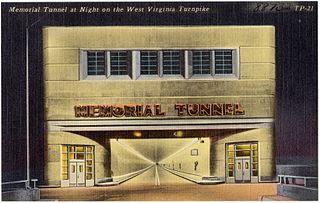
The Memorial Tunnel is a 2,802 feet (854 m) two-lane vehicular tunnel that formerly carried the West Virginia Turnpike through/under Paint Creek Mountain in Standard, West Virginia in Kanawha County. Closed to interstate traffic since 1987, the tunnel served as the Center for National Response for military first responders to train for various situations that may arise in such a location without alarming the general public. In 2020, the Center for National Response ceased operations at the tunnel. In February 2022, an agreement was made between the West Virginia Adjutant General's office and a local farmer to utilize the facility to grow mushrooms.
The Negro Mountain Tunnel is a tunnel located in Negro Mountain in Somerset County, Pennsylvania. It was built by New York Central Railroad as part of the proposed but never completed South Pennsylvania Railroad, which over time became known as "Vanderbilt's Folly". The tunnel is located near milepost 116.7 on the Pennsylvania Turnpike where it is ten miles east of the Quemahoning Tunnel, 16 miles east of the Laurel Hill Tunnel, and seven miles west of the Allegheny Mountain Tunnel currently used by the Turnpike.
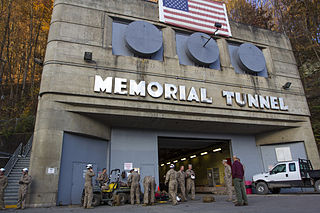
The Center for National Response was formerly located inside a former 2,802 feet (854 m) two-lane vehicular tunnel opened November 8, 1954 as part of the West Virginia Turnpike. Originally known as Memorial Tunnel, the tunnel formerly carried West Virginia Turnpike through/under Paint Creek Mountain in Standard, West Virginia in Kanawha County. Its construction required the movement of 91,000 cubic yards (70,000 m3) of earth, and was the first tunnel in the nation to have closed-circuit television monitoring. at a final cost of $5 million. The facility was last administered by the West Virginia National Guard.