Neighbourhoods of Allahabad

Last updated

The Old Allahabad City, at the south of Prayagraj Junction Railway Station, consists of neighborhoods like Chowk, Johnstongunj, Dariyabad, Khuldabad etc. [1] and was in existence from the time of Akbar. Some magnificent structures erected in this era consist of the Khusro Bagh and the Allahabad Fort. In the north of Railway Station, the New Allahabad City consists of neighborhoods like Lukergunj, Civil Lines, Georgetown, Tagoretown, Bharadwaj Puram, Ashok Nagar, Mumfordgunj etc., which are relatively new and were built during the British rule. [2] These neighborhoods reflect British architecture like the All Saints Cathedral, Alfred Park and Allahabad High Court. Newer residential areas include neighborhoods like Kareli and suburbs like Naini Jhunsi and Manauri bajar.

Contents

Allengunj

Area close to Prayag Junction, has staff selection board office there, lots of women hostels there.

Alopibagh

Alopibagh is a locality/township of Allahabad, Uttar Pradesh, India. The locality is close to the Kumbh Mela area, the Sangam, the rivers Ganges and Yamuna, and one of the most ancient Hindu temples of India, the Alopi Devi Mandir, is also in this locality. Alopibagh is adjacent to Daraganj, the oldest suburb of Allahabad and the most important bathing Ghat on the bank of Ganges.

Atala

Attarsuiya

Bahadurgunj

Bai-Ka-Bagh

Bairahana

Bairahana is further divided into two localities:New Bairahana and the Old Bairahana. Near Bairahana chauraha is a medieval cemetery also called the "Gora Kabristan", where the dead bodies of British soldiers killed during 1857 revolt were buried.

Beli Colony

Benigunj

Benigunj is situated near to railways station.

Bharadwaj Puram

Bharadwaj Puram is a neighborhood in Allahabad in central part of the city. It is in between Tagore Town and Daraganj. It is near the major commercial centers of the city such as Katra and Civil Lines. There is a market within this locality on the Matiyara road which is very popular for shopping and dining options. There are several schools, hospitals, parks as well in this neighborhood.

Chatham Lines

Chowk

Chowk is the historic city centre of the Old Allahabad city. It is situated at southern part of Allahabad Municipal Council. 1 Chowk serves as a traditional bazaar with The Grand Trunk Road running through the centre of it. Chowk is a historical point, where once stood the Neem tree where numerous freedom fighters were hanged in the first Indian War of Independence.

Civil Lines

Allahabad city from Civil Lines Allahabad city.jpg
Allahabad city from Civil Lines

Formerly known as Cannington [3] and Canning Town, [2] it is the central business district of Allahabad and is famous for its urban setting, gridiron plan [4] roads and high rise buildings. Built in 1857, under the supervision of Cuthbert Bensley Thornhill, it was the largest town-planning project carried out in India before the establishment of New Delhi. [2] [4]

Colonelgunj

Daraganj

Darbhanga

Dariyabad

Dhoomangunj

Georgetown

Georgetown is a neighborhood of Allahabad, India. It is a residential area in the central part of the city mainly occupied by the white collar workers, doctors and advocates. It also houses a large number of hospitals and clinics. Georgetown is famous for is affluent surroundings and apartments. It is bordered by Kamla Nehru Road in the west, Thornhill Road, MG Marg in the south and Tagoretown in the west. Notable landmarks located in and near the neighborhood are Alfred Park and Lowther Castle.

Govindpur

Johnstongunj

Kareli

Kareli (officially known as Kareli Scheme) is a residential neighborhood of Allahabad. Developed by Awas Vikas in 1979, it was one of the biggest planned neighborhoods in India. The neighborhood is sub divided into neighborhoods like GTB Nagar, Gaus Nagar, Allahabad, Shams Nagar, Allahabad and Rehmat Nagar Colony, Allahabad. Kareli is the second largest colony of India in terms of Area and is one of the most expensive residential localities of Allahabad. It is also known as Officer's colony by the localas as the large number of people who served as government servants like IAS, IPS, PCS, etc inhabited the place.The neighborhood was predominately occupied by the members of the mercantile middle class of Meerapur and Attarsuiya, and white collar workers from several public sector undertakings and private companies established in the new industrial region of Naini. It was later overwhelmed by a richer population after the oil boom and privatization. However it is not mintained well. The roads have so many mudhols.

Katra

Khuldabad

Khusrobagh

Kydganj

Kalandipuram Colony

Lukergunj

Lukergunj is a posh residential area famous for its Victorian era bungalows and high-rise apartments. Lukergunj, well known for its clubbing culture, was once predominantly occupied by British and Anglo Indians. It is situated one kilometer south west from the Allahabad Railway Station.

Meerapur

Meerapur is an neighborhood/Locality in Allahabad. It is mainly famous for eateries as there are many sweet shops and markets for visitors. Old temples, mosques are the main attraction and symbolizes brotherhood. Meerapur is surrounded by River Yamuna from one side near Bargad Ghat.

Meergunj

This neighborhood is the infamously claimed red-light district of the city. [5] Apart from that it is also a densely populated residential area and a marketplace. It is located near Chowk.

Mumfordgunj

Muirabad

Mutthiganj

North Malaka

Pac Lines

Police Lines

Prayagraj

Prayagraj is one of the largest cities of the State of Uttar Pradesh in India. It encompasses a large area and is an inland peninsula surrounded by the rivers Ganges and Yamuna from three sides with only one side connected to the mainland. Along with a large number of areas within Prayagraj City, there are several satellite cities on the other side of the rivers Ganges and Yamuna, and are considered as satellite cities of Prayagraj. There are also a large number of Townships and Villages near Prayagraj City Within Prayagraj District. Posh pockets of the city include neighborhoods like Civil Lines, Cantonment or Allahabad Cantt, Kotwali, Dhoomanganj, Colonelganj, Mahaveer Puri, Shivkuti, Georgetown, Bharadwaj Puram, Kydgunj, and Attarsuiya.

Preetam Nagar

Rajapur

Rajrooppur

Rambagh

Rani Mandi

Sadiyapur(Nishad Nagar)

Satti Chaura

Shastri Nagar

Sohbatiabagh

South Malaka

South Malaka is a locality/township of Allahabad, Uttar Pradesh, India. It is close to the railway track connecting Allahabad to Varanasi and Gorakhpur. The other important institutions in the locality are Government Inter College and U.P.Government Central Library.

Sulem Sarai

Tagoretown

Teliyargunj

Suburbs of Allahabad

Related Research Articles

Kaushambi district District of Uttar Pradesh in India

Kaushambi district is a district in the state of Uttar Pradesh in India. Manjhanpur is the district headquarters. The district was carved from Prayagraj district on 4 April 1997. Manauri bajar connects Prayagraj and Kaushambi districts by railway over a bridge on SH-95. Manjhanpur is south-west of Prayagraj on the north bank of the Yamuna river, about 55 kilometres (34 mi) from the city. It is surrounded by Chitrakoot district on the south, Pratapgarh district on the north, Allahabad district on the east and Fatehpur district on the west. Kaushambi is part of Prayagraj division. The nearest railway station, in Bharwari, connects with Delhi, Allahabad, Kolkata, Gaya and Kanpur.

Jhusi or Jhunsi is a town and a part of Allahabad municipal corporation in Allahabad district in the Indian state of Uttar Pradesh. It was formerly called Pratishthan Pur or Puri.

Shankargarh is a town and a nagar panchayat in Allahabad district in the Indian state of Uttar Pradesh.

Sirathu is a town and Nagar Panchayat in Kaushambi district in the Indian state of Uttar Pradesh. It is one of oldest town in Kaushambi district. The town has a population of approximately 2700.

Allahpur, Officially Bharadwaj Puram is a locality (township) of Allahabad, Uttar Pradesh, India.

Kareli is a residential neighborhood of Allahabad. Developed by Awas Vikas in 1979, it was one of the biggest planned neighborhoods in India. The neighborhood is sub divided into neighborhoods like GTB Nagar, Gaus Nagar, Allahabad, Shams Nagar, Allahabad and Rehmat Nagar Colony, Allahabad. Kareli is the second largest colony of India in terms of Area and is one of the most expensive residential localities of Allahabad. It is also known as Officer's colony by the localas as the large number of people who served as government servants like IAS, IPS, PCS, etc inhabited the place.

Naini Neighbourhood in Allahabad division, Uttar Pradesh, India

Naini is a satellite neighborhood and a twin city of Allahabad, Uttar Pradesh, India. By the 1950s Naini was established as the chief industrial area of the city.

Allahabad Metropolis in Uttar Pradesh, India

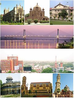
Allahabad, officially known as Prayagraj, also known as Ilahabad, is a metropolis in the Indian state of Uttar Pradesh. It is the administrative headquarters of the Allahabad district—the most populous district in the state and 13th most populous district in India—and the Allahabad division. The city is the judicial capital of Uttar Pradesh with the Allahabad High Court being the highest judicial body in the state. As of 2011, Allahabad is the seventh most populous city in the state, thirteenth in Northern India and thirty-sixth in India, with an estimated population of 1.53 million in the city. In 2011 it was ranked the world's 40th fastest-growing city. Allahabad, in 2016, was also ranked the third most liveable urban agglomeration in the state and sixteenth in the country. Hindi is the most widely spoken language in the city.

Culture of Uttar Pradesh Indian culture with roots in Hindi and Urdu culture

The Culture of Uttar Pradesh is an Indian culture which has its roots in Hindi and Urdu literature, music, fine arts, drama and cinema. Lucknow, the capital of Uttar Pradesh, has historical monuments including Bara Imambara and Chhota Imambara, and has preserved the damaged complex of the Oudh-period British Resident's quarters, which are being restored.

Tourism in Uttar Pradesh Overview of tourism in the Indian state of Uttar Pradesh

Situated in the northern part of India, bordering with the capital of India New Delhi, Uttar Pradesh is one of the most popular and an established tourist destination for both Indians and non-Indians alike in India. The most populous state of India, Uttar Pradesh contains many historical monuments and places of religious significance. Geographically, Uttar Pradesh is very diverse, with Himalayan foothills in the extreme north and the Gangetic Plain in the centre. It is also home of India's most visited sites, the Taj Mahal, and Hinduism's holiest city, Varanasi. Kumbh city, Prayagraj. Kathak, one of the eight forms of Indian classical dances, originated from Uttar Pradesh. Uttar Pradesh is at the heart of India, hence it is also known as The Heartland of India. Cuisine of Uttar Pradesh like Awadhi cuisine, Mughlai cuisine, Kumauni cuisine are very famous not only in India but also many places abroad and Pratapgarh is also famous for Rajputana.

New Yamuna Bridge Cable-Stayed Bridge in Prayagraj, Uttar Pradesh

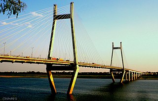
The New Yamuna Bridge is a cable-stayed bridge located in Allahabad (Prayagraj). The bridge was constructed by the end of 2004 with the aim of minimizing the traffic over the Old Naini Bridge. The bridge runs north–south across the Yamuna river connecting the city of Prayagraj to its neighborhood of Naini. The construction was consulted by COWI A/S, a Danish consulting company. Main construction was done by Hyundai and was successfully completed in 2004.

Old Naini Bridge Bridge in India

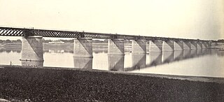
The Old Naini Bridge is one of the longest and oldest bridges in India, located in Prayagraj. It is a double-decked steel truss bridge which runs across the Yamuna river in the southern part of the city. The bridge runs north-south across the Yamuna river connecting the city of Prayagraj to the neighbouring area of Naini. Its upper deck has a two lane railway line which connects Naini Junction railway station to Allahabad Junction railway station, while the lower deck has successfully been facilitating roadway services since 1927.

Prayagraj Junction railway station Railway station in Uttar Pradesh, India

Prayagraj Junction, previously known as Allahabad Junction, is a railway station on the Howrah–Delhi main line, Allahabad–Mau–Gorakhpur main line and Howrah–Allahabad–Mumbai line. It is the headquarters of the North Central Railway zone. It is located in Allahabad in the Indian state of Uttar Pradesh. It serves Allahabad and the surrounding areas.

Fatehpur railway station Railway station in Uttar Pradesh, India

Fatehpur railway station is on the Mughalsarai–Kanpur section of the Howrah–Delhi main line under Allahabad railway division. It is located in Fatehpur district in the Indian state of Uttar Pradesh. It serves Fatehpur and the surrounding areas.

Bharadwaj Puram is a neighborhood of Prayagraj in Uttar Pradesh, India. It is sandwiched between Tagore Town and Daraganj, close to the bank of the River Ganga. Nearby are George Town, Allahabad University, Katra, and Civil Lines, as well as tourist attractions such as Alfred Park, Sangam, Anand Bhavan, and numerous temples. This neighborhood also has many commercial centers, schools, hospitals, ashrams, and parks. Bharadwaj Puram's main market is located on Matiyara Road and is a popular shopping destination. Alopi Bagh is in the south of the neighbourhood.

Amaniganj is a town in Milkipur tehsil, Faizabad district in the Indian state of Uttar Pradesh. Amaniganj is situated on Milkipur-Rudauli road and is 51 km away from district headquarters Ayodhya city. Amaniganj is a block in Ayodhya, Uttar Pradesh.

Prayag Junction railway station is an important railway station in Allahabad district, Uttar Pradesh. It serves Prayag town in Allahabad (Prayagraj). It consists of three platforms. The NR is developing the neighbouring Prayagraj sangam station as a coaching terminal. It is designed by architect M K Singh in the year 2018. There will be five new platforms, two washing lines, and a new station building with basement.

Manauri is a satellite township/neighborhood of Allahabad, Uttar Pradesh state of India. It is a market, 18 km west of Allahabad city headquarter. It lies on the border of Allahabad and Kaushambi district of Uttar Pradesh. On this town, a Railway Station lying nearby on the New Delhi - Howrah main line and an Air Force Station nearby on NH-2 is also named. Due to proximity of the Town with main Railway line and National highway, it has developed into a local trade market. The town has a huge population of more than 15 thousand, both of Hindus and Muslims. The main occupation is grains, vegetable and fruits agriculture along with traditional works like metal works, blacksmith, carpenter, glass works, and construction labours.

Manauri railway station is situated in Manauri bajar, Allahabad district, Uttar Pradesh, India. Its station code is MRE. It is one of the major railway stations for Kaushambi district and west area of Allahabad district

References

  1. "Uneasy calm prevails in old Allahabad areas". The Times of India . 19 August 2012. Archived from the original on 28 June 2013. Retrieved 13 September 2013.
  2. 1 2 3 Jonathan M. Bloom, Sheila Blai (2009). The Grove Encyclopedia of Islamic Art and Architecture, Volume 3. Oxford University Press. p. 57. ISBN   978-8125013839.
  3. Chatterton, Eyre. "A History of the Church of England in India". anglicanhistory.org. Retrieved 11 September 2013.
  4. 1 2 Henry George Keene (1875). A Hand-book for Visitors to Lucknow: With Preliminary Notes on Allahabad and Cawnpore. J. Jetley. pp. 14–15. ISBN   8120615271.
  5. "Sex racket busted in Allahabad, 19 women detained". Zee News . 17 May 2012. Retrieved 13 September 2013.