New Salem-Buffington, Pennsylvania

Last updated

New Salem-Buffington
Former CDP
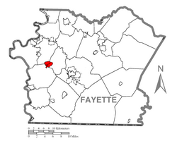
Map of New Salem-Buffington, Fayette County, Pennsylvania Highlighted.png
Location of New Salem-Buffington in Fayette County
Coordinates: 39°55′31″N79°50′16″W / 39.92528°N 79.83778°W / 39.92528; -79.83778
CountryUnited States
StatePennsylvania
County Fayette
Area
  Total1.2 sq mi (3 km2)
Population
 (2000)
  Total808
  Density670/sq mi (260/km2)
Time zone UTC-4 (EST)
  Summer (DST) UTC-5 (EDT)
Area code 724

New Salem-Buffington was a census-designated place (CDP) in Fayette County, Pennsylvania, United States, and part of the Pittsburgh Metro Area. The population was 808 at the 2000 census. For the 2010 census the area was split into two CDPs, New Salem and Buffington. Both communities are located in Menallen Township.

Contents

Geography

New Salem-Buffington was located at 39°55′31″N79°50′16″W / 39.92528°N 79.83778°W / 39.92528; -79.83778 (39.925298, −79.837655). [1]

According to the United States Census Bureau, the CDP had a total area of 1.2 square miles (3.1 km2), all of it land.

Demographics

As of the 2000 census, [2] there were 808 people, 318 households, and 232 families residing in the CDP. The population density was 685.8 inhabitants per square mile (264.8/km2). There were 362 housing units at an average density of 307.3 per square mile (118.6/km2). The racial makeup of the CDP was 93.19% White, 6.56% African American and 0.25% Native American. Hispanic or Latino of any race were 0.12% of the population.

There were 318 households, out of which 29.9% had children under the age of 18 living with them, 52.2% were married couples living together, 16.7% had a female householder with no husband present, and 27.0% were non-families. 25.2% of all households were made up of individuals, and 14.5% had someone living alone who was 65 years of age or older. The average household size was 2.54 and the average family size was 3.01.

In the CDP, the population was spread out, with 23.3% under the age of 18, 8.0% from 18 to 24, 26.1% from 25 to 44, 23.3% from 45 to 64, and 19.3% who were 65 years of age or older. The median age was 40 years. For every 100 females, there were 76.4 males. For every 100 females age 18 and over, there were 77.7 males.

The median income for a household in the CDP was $28,875, and the median income for a family was $34,643. Males had a median income of $21,406 versus $16,607 for females. The per capita income for the CDP was $13,508. About 13.0% of families and 15.5% of the population were below the poverty line, including 14.8% of those under age 18 and 13.8% of those age 65 or over.

Notable people

Related Research Articles

<span class="mw-page-title-main">Seven Trees, San Jose</span> Neighborhood of San Jose in Santa Clara, California, United States

Seven Trees is a Neighborhood of San Jose, California. It was formerly an unincorporated census-designated place surrounded completely by South San Jose and it was annexed into San Jose on November 23, 2009.

Roosevelt Gardens is a census-designated place (CDP) in Broward County, Florida, United States. The population was 2,749 at the 2020 census.

<span class="mw-page-title-main">Salem, Georgia</span> CDP in Georgia, United States

Salem is a census-designated place (CDP) in Upson County, Georgia, United States. The population was 310 at the 2010 census.

<span class="mw-page-title-main">Lawai, Hawaii</span> Census-designated place in Hawaii, United States

Lāwaʻi is a census-designated place (CDP) in Kauaʻi County in the U.S. state of Hawaiʻi. The population was 2,578 at the 2020 census, up from 1,984 at the 2000 census.

<span class="mw-page-title-main">Kenwood, Ohio</span> Census-designated place in Ohio, United States

Kenwood is a census-designated place (CDP) in Sycamore Township, Hamilton County, Ohio, United States. The population was 7,570 at the 2020 census. It is a major shopping destination for the Cincinnati area, featuring properties such as Kenwood Towne Centre and The Kenwood Collection.

<span class="mw-page-title-main">Logan Elm Village, Ohio</span> CDP in Ohio, United States

Logan Elm Village is a census-designated place (CDP) in Pickaway County, Ohio, United States, near the site of the Logan Elm. The population was 1,062 at the 2000 census.

<span class="mw-page-title-main">Uniontown, Ohio</span> CDP in Ohio, United States

Uniontown is a census-designated place (CDP) in Stark County, Ohio, United States. The population was 7,173 at the 2020 census.

<span class="mw-page-title-main">Labish Village, Oregon</span> Unincorporated community in the state of Oregon, United States

Labish Village is a census-designated place (CDP) in Marion County, Oregon, United States. The population was 454 at the 2020 census. It is part of the Salem Metropolitan Statistical Area.

<span class="mw-page-title-main">Russellton, Pennsylvania</span> Census-designated place in Pennsylvania, United States

Russellton is a census-designated place (CDP) in Allegheny County, Pennsylvania, United States. The population was 1,330 at the 2020 census.

<span class="mw-page-title-main">East Uniontown, Pennsylvania</span> Census-designated place in Pennsylvania, United States

East Uniontown is a census-designated place (CDP) in Fayette County, Pennsylvania, United States. The population was 2,419 at the 2010 census, down from 2,760 at the 2000 census.

<span class="mw-page-title-main">Hiller, Pennsylvania</span> Census-designated place in Pennsylvania, United States

Hiller is an unincorporated community and census-designated place in Fayette County, Pennsylvania, United States. As of the 2010 census, it had a population of 1,155, down from 1,234 at the 2000 census.

<span class="mw-page-title-main">Hopwood, Pennsylvania</span> Census-designated place in Pennsylvania, United States

Hopwood is a census-designated place (CDP) in Fayette County, Pennsylvania, United States. The population was 2,090 at the 2010 census, up from 2,006 at the 2000 census. It is located in North Union and South Union townships. The village was named after John Hopwood.

<span class="mw-page-title-main">Leith-Hatfield, Pennsylvania</span> Census-designated place in Pennsylvania, United States

Leith-Hatfield is a census-designated place (CDP) in Fayette County, Pennsylvania, United States. The population was 2,546 at the 2010 census, down from 2,820 at the 2000 census. The twin villages of Leith and Hatfield are located in South Union Township.

<span class="mw-page-title-main">Menallen Township, Fayette County, Pennsylvania</span> Township in Pennsylvania, United States

Menallen Township is a township in Fayette County, Pennsylvania, United States. It is part of the Pittsburgh metropolitan area. The population was 4,092 at the 2020 census, a decline from the figure of 4,205 tabulated in 2010. The Uniontown Area School District serves the region.

<span class="mw-page-title-main">Oliver, Pennsylvania</span> Census-designated place in Pennsylvania, United States

Oliver is a census-designated place (CDP) in Fayette County, Pennsylvania, United States. The population was 2,535 at the 2010 census, down from 2,925 at the 2000 census. Oliver is located in North Union Township.

<span class="mw-page-title-main">Fairdale, Pennsylvania</span> Census-designated place in Pennsylvania, United States

Fairdale is a community and census-designated place (CDP) in Greene County, Pennsylvania, United States. The population was 2,059 at the 2010 census.

<span class="mw-page-title-main">East Berwick, Pennsylvania</span> Census-designated place in Pennsylvania, United States

East Berwick is a census-designated place (CDP) in Salem Township, Luzerne County, Pennsylvania, United States. The population was 2,007 at the 2010 census.

<span class="mw-page-title-main">Sheffield, Pennsylvania</span> Census-designated place in Pennsylvania, United States

Sheffield is a census-designated place (CDP) within Sheffield Township in southeastern Warren County, Pennsylvania, United States. It is named after Sheffield, England. The population was 1,123 as of the 2010 census.

<span class="mw-page-title-main">Brattleboro (CDP), Vermont</span> CDP in Vermont, United States

Brattleboro is a census-designated place (CDP) corresponding to the densely populated core of the town of Brattleboro in Windham County, Vermont, United States. The population was 8,289 at the 2000 census.

Fryeburg is a census-designated place (CDP) in the town of Fryeburg in Oxford County, Maine, United States. The population was 1,444 at the 2020 census.

References

  1. "US Gazetteer files: 2010, 2000, and 1990". United States Census Bureau. February 12, 2011. Retrieved April 23, 2011.
  2. "U.S. Census website". United States Census Bureau . Retrieved January 31, 2008.