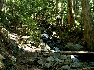
British Columbia mainland coastal forests is a temperate coniferous forest ecoregion the Pacific coast of North America, as defined by the World Wildlife Fund (WWF) categorization system.

The Gulf of St. Lawrence lowland forests are a temperate broadleaf and mixed forest ecoregion of Eastern Canada, as defined by the World Wildlife Fund (WWF) categorization system.

The Alberta Mountain forests are a temperate coniferous forests ecoregion of Western Canada, as defined by the World Wildlife Fund (WWF) categorization system.

The Alberta–British Columbia foothills forests are a temperate coniferous forests ecoregion of Western Canada, as defined by the World Wildlife Fund (WWF) categorization system. This ecoregion borders Canada's taiga and contains a mix of subarctic forest and temperate forest species as a result. This makes the region an ecotone region, or a region that acts as a buffer between two other biomes.

The Eastern Canadian forests is a taiga ecoregion in Eastern Canada, as defined by the World Wildlife Fund (WWF) categorization system.

The Eastern Canadian Shield taiga is an ecoregion of Canada as defined by the World Wildlife Fund (WWF) categorization system.

The Yukon Interior dry forests is a taiga ecoregion of Canada.

The Muskwa-Slave Lake forests ecoregion covers Canadian taiga in northwestern Alberta, northeastern British Columbia and a large portion of the southwestern Northwest Territories around the Mackenzie River valley and the Great Slave Lake.

The North Central Rockies forests is a temperate coniferous forest ecoregion of Canada and the United States. This region overlaps in large part with the North American inland temperate rainforest and gets more rain on average than the South Central Rockies forests and is notable for containing the only inland populations of many species from the Pacific coast.

The Northeast Siberian taiga ecoregion is an area of "sparse taiga forest" between the Lena River and the Kolyma River in northeastern Siberia, Russia. The ecoregion's internal borders form a patchwork of territory constituting the southern part of the East Siberian Lowland, as well as lowlands around the East Siberian Mountains, including the ridges and peaks of the Verkhoyansk Range and the Chersky Range. On the southern border of the ecoregion is the north coast of the Sea of Okhotsk, giving the region maritime boreal forests as well as the continental forests situated inland. The ecoregion is one of the largest tracts of virgin boreal forest in the world, due to the very sparse population and difficult access. It is mostly in the Sakha Republic.
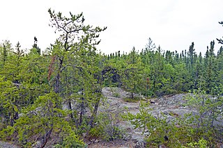
Northern Canadian Shield taiga is a taiga ecoregion located in northern Canada, stretching from Great Bear Lake in the Northwest Territories to Hudson Bay in eastern Nunavut. The region supports conifer forests to its northern edge, where the territory grades into tundra. The open forest in this transition zone is characterized by widely scattered, stunted stands of black spruce and tamarack, with some white spruce. The ecoregion lies over the northwestern extent of the Canadian Shield.

The Napo moist forests (NT0142) is an ecoregion in the western Amazon rainforest of Colombia, Ecuador and Peru.

The Daurian forest steppe ecoregion is a band of grassland, shrub terrain, and mixed forests in northeast Mongolia and the region of Siberia, Russia that follows the course of the Onon River and Ulz River. The region has been described as a “sea of grass that forms the best and most intact example of an undisturbed steppe ecosystem and is also one of the last areas in the Palearctic that still supports stable herds of larger vertebrates” in a semi-mountainous area. The area also has flat wetlands that are important to migratory birds. The ecoregion is in the Palearctic realm, with a dry-winter subarctic climate that borders on a very cold semi-arid climate (BSk) in its southwestern parts. It covers 209,012 km2 (80,700 sq mi).

Pacific Coastal Mountain icefields and tundra is a tundra ecoregion in Alaska, British Columbia, and Yukon, as defined by the World Wildlife Fund (WWF) categorization system.

The Persian Gulf desert and semi-desert ecoregion covers the desert coastal plain of the northwest Persian Gulf, that is, on the northeast Arabian Peninsula, from Kuwait in the north to a small coastal sector in the United Arab Emirates to the southeast.

The Davis Highlands tundra ecoregion covers the Baffin Mountains on the northeast coast of Baffin Island and Bylot Island, facing Baffin Bay in Nunavut, northern Canada. The terrain is extremely rugged, heavily glaciated, with many deep fjords, and very cold. About half of the territory is moss and lichen tundra, the other half bare rock and ice. The region is wetter than the much drier regions to the southwest of the Baffin Islands.

The High Arctic tundra ecoregion covers most of Canada's northern Arctic Archipelago - from the Queen Elizabeth Islands nearest to Greenland in the northeast, and down through the center of Baffin Island. Much of the northern islands are covered in ice, and the climate is very dry with as little as 50 mm/year in places. The ecoregion has very little human habitation, and most of the non-ice terrain is moss and lichen cover. The region supports viable populations of arctic mammals such as muskox, arctic wolves, arctic foxes, arctic hares, polar bears, and caribou.

The Interior Yukon-Alaska alpine tundra ecoregion covers alpine, sub-alpine, and boreal forest areas along the cordillera of Interior Alaska and south-central Yukon Territory. Geologically, they are the disjunct uplands of the Yukon-Tanana Terrane plus a southern extension of the Brooks Range. The cover is extensive 'dark taiga' of closed spruce forest, open forest of other species, and alpine vegetation at higher altitudes. The region is mostly wilderness and relatively untouched by human development.
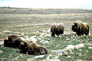
The Middle Arctic tundra ecoregion covers a broad stretch of northern Canada - the southern islands of the Arctic Archipelago, plus the northern mainland of Nunavut and, across Hudson Bay to the east, a portion of northern Quebec. This is the coldest and driest ecoregion in Canada, and can be referred to as a 'polar desert'. It is an important region for breeding and migratory birds, and supports 80% of the world's muskox.

The Ogilvie–MacKenzie alpine tundra ecoregion covers the mountainous middle of the Yukon Territory in Canada, with extensions into the Northwest Territories. The vegetation is alpine and subalpine open forest of stunted spruce, fir and pine. The area is rugged but sections appear to have been unglaciated in the late Pleistocene and there are therefore relic species in the region. The area is remote and supports large, sustainable predator-prey systems.

