"},"population_total":{"wt":"141894"},"population_density_km2":{"wt":""},"coordinates":{"wt":"{{coord|26|20|28|N|59|51|52|E|dim:60km|display=inline,title}}"},"coordinates_footnotes":{"wt":"{{Cite map |author=((OpenStreetMap contributors)) |url=https://www.openstreetmap.org/?mlat=26.341111&mlon=59.864444&zoom=10#map=10/26.3411/59.8644|website=[[OpenStreetMap]] |title=Nik Shahr County|date=12 January 2025|access-date=12 January 2025|lang=fa\n}}"},"timezone":{"wt":"[[Iran Standard Time|IRST]]"},"utc_offset":{"wt":"+3:30"},"elevation_footnotes":{"wt":""},"elevation_m":{"wt":""},"elevation_ft":{"wt":""},"website":{"wt":""},"footnotes":{"wt":"{{GEOnet3|9206445}}"}},"i":0}}]}" id="mwCQ">County in Sistan and Baluchestan, Iran
Nik Shahr County Persian: شهرستان نیکشهر | |
---|---|
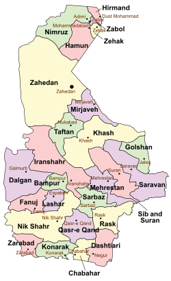
![]() Location of Nik Shahr County in Sistan and Baluchestan province (bottom left, yellow) | |
![]() Location of Sistan and Baluchestan province in Iran | |
Coordinates: 26°20′28″N59°51′52″E / 26.34111°N 59.86444°E [1] | |
Country | Iran |
Province | Sistan and Baluchestan |
Capital | Nik Shahr |
Districts | Central, Ahuran, Bent |
Population (2016) [2] | |
• Total | 141,894 |
Time zone | UTC+3:30 (IRST) |
Nik Shahr County can be found at GEOnet Names Server, at this link, by opening the Advanced Search box, entering "9206445" in the "Unique Feature Id" form, and clicking on "Search Database". |
Nik Shahr County (Persian : شهرستان نیکشهر) is in Sistan and Baluchestan province, Iran. Its capital is the city of Nik Shahr. [3]
After the 2011 National Census, Fanuj District was separated from the county in the establishment of Fanuj County, and Qasr-e Qand District to establish Qasr-e Qand County. [4] Additionally, Chanef Rural District was separated from Lashar District in the formation of Ahuran District, including the new Kahiri Rural District. [5]
After the 2016 census, Lashar District [a] was separated from the county in establishing Lashar County. [6] The village of Chanef was elevated to the status of a city. [7]
At the time of the 2006 census, the county's population was 185,355 in 37,858 households. [8] The following census in 2011 counted 212,963 people in 50,419 households. [9] The 2016 census measured the population of the county as 141,894 in 37,207 households. [2]
Nik Shahr County's population history and administrative structure over three consecutive censuses are shown in the following table.
Administrative Divisions | 2006 [8] | 2011 [9] | 2016 [2] |
---|---|---|---|
Central District | 50,842 | 61,117 | 66,716 |
Chahan RD | 9,771 | 11,378 | 12,727 |
Hichan RD | 10,155 | 12,305 | 13,441 |
Mahban RD | 8,309 | 9,830 | 10,421 |
Mokht RD | 9,340 | 11,715 | 12,395 |
Nik Shahr (city) | 13,267 | 15,889 | 17,732 |
Ahuran District | 12,453 | ||
Chanef RD | 9,964 | ||
Kahiri RD | 2,489 | ||
Chanef (city) [b] | |||
Bent District | 21,259 | 24,641 | 28,722 |
Bent RD | 9,536 | 10,482 | 12,192 |
Dastgerd RD | 4,334 | 5,250 | 6,260 |
Tutan and Mohammadan RD | 3,087 | 3,615 | 4,448 |
Bent (city) | 4,302 | 5,294 | 5,822 |
Fanuj District [c] | 38,459 | 45,637 | |
Fanuj RD | 8,938 | 11,361 | |
Kotij RD | 11,168 | 12,699 | |
Maskutan RD | 8,647 | 10,000 | |
Fanuj (city) | 9,706 | 11,577 | |
Lashar District [a] [d] | 37,073 | 42,114 | 33,973 |
Chanef RD | 10,497 | 11,394 | |
Lashar-e Jonubi RD | 12,279 | 14,299 | 15,050 |
Lashar-e Shomali RD | 11,302 | 12,785 | 14,204 |
Espakeh (city) | 2,995 | 3,636 | 4,719 |
Qasr-e Qand District [e] | 37,722 | 39,414 | |
Holunchekan RD | 9,168 | 11,226 | |
Sarbuk RD | 17,728 | 19,625 | |
Qasr-e Qand (city) | 10,826 | 8,563 | |
Total | 185,355 | 212,963 | 141,894 |
RD = Rural District |
Media related to Nik Shahr County at Wikimedia Commons