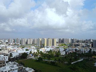
Surat is a city in the western Indian state of Gujarat. The word Surat directly translates to face in Urdu, Gujarati and Hindi. Located on the banks of the river Tapti near its confluence with the Arabian Sea, it used to be a large seaport. It is now the commercial and economic centre of South Gujarat, and one of the largest urban areas of western India. It has well-established diamond and textile industry, and is a major supply centre for apparels and accessories. About 90% of the world's diamonds are cut and polished in Surat. It is the second largest city in Gujarat after Ahmedabad and the eighth largest city by population and ninth largest urban agglomeration in India. It is the administrative capital of the Surat district.
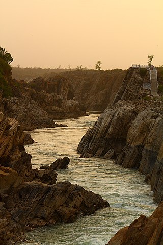
The Narmada River, previously also known as Narbada or anglicised as Nerbudda, is the 5th longest river in India and overall the longest west-flowing river in the country. It is also the largest flowing river in the state of Madhya Pradesh. This river flows through the states of Madhya Pradesh and Gujarat in India. It is also known as the "Lifeline of Madhya Pradesh and Gujarat" due to its huge contribution to the two states in many ways. The Narmada River rises from the Amarkantak Plateau in Anuppur district in Madhya Pradesh. It forms the traditional boundary between North and South India and flows westwards for 1,312 km (815.2 mi) before draining through the Gulf of Khambhat into the Arabian Sea, 30 km (18.6 mi) west of Bharuch city of Gujarat.

The Satpura Range is a range of hills in central India. The range rises in eastern Gujarat running east through the border of Maharashtra and Madhya Pradesh and ends in Chhattisgarh. The range parallels the Vindhya Range to the north, and these two east–west ranges divide Indian Subcontinent into the Indo-Gangetic plain of northern India and the Deccan Plateau of the south. The Narmada River originates from north-eastern end of Satpura in Amarkantak, and runs in the depression between the Satpura and Vindhya ranges, draining the northern slope of the Satpura range, running west towards the Arabian Sea. The Tapti River originates in the eastern-central part of Satpura, crossing the range in the center and running west at the range's southern slopes before meeting the Arabian Sea at Surat, draining the central and southern slopes of the range. Multai, the place of Tapti river origin is located about 465 kilometer far, south-westerly to Amarkantak, separated across by the hill range. The Godavari River and its tributaries drain the Deccan plateau, which lies south of the range, and the Mahanadi River drains the easternmost portion of the range. The Godavari and Mahanadi rivers flow into the Bay of Bengal. At its eastern end, the Satpura range meets the hills of the Chotanagpur Plateau. The Satpura Range is a horst mountain and is flanked by Narmada Graben in the north and much smaller but parallel Tapi Graben in the south.

The Tapti River is a river in central India located to the south of the Narmada river that flows westwards before draining into the Arabian Sea. The river has a length of around 724 km and flows through the states of Maharashtra, Gujarat and Madhya Pradesh. It flows through the city of Surat, in Gujarat, and is crossed by the Magdalla, ONGC Bridge.
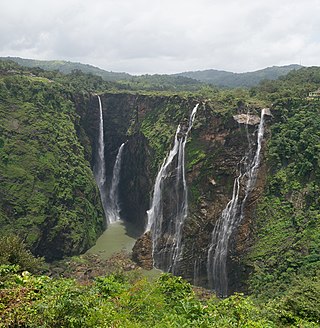
Jog Falls is a waterfall on the Sharavati river located in Siddapur taluk of Uttara Kannada district and its view point in Kargal town of Shimoga district, Karnataka, India. It is the second highest plunge waterfall in India. It is a segmented waterfall which depends on rain and season to become a plunge waterfall. The falls are major attractions for tourists and is ranked 36th in the list of free-falling waterfalls, 490th in the world by list of waterfalls by total height, 128th in the list of single-drop waterfalls in the World by the waterfall database.

Narmada district is an administrative district in the state of Gujarat in India. The district headquarters are located at Rajpipla. The district is bounded by Vadodara and Chhota Udaipur districts in the north, by Nandurbar district of Maharashtra state in the east, by Surat and Tapi districts in the south and by Bharuch district in the west. The district occupies an area of 2,755 km2 and has a population of 590,297. It was 10.44% urban as of 2011. As of 2011, it is the third least populous district of Gujarat, after Dang and Porbandar.

Navsari is an administrative district in the state of Gujarat in India, with its headquarters at the city of Navsari. The district covers an area of 2,211 square kilometres and was formed in 1997 after Valsad district was split into Valsad and Navsari districts. It is the largest producer of chikoos in India.

Surat is a district in the state of Gujarat, city as the administrative headquarters of this district. It is surrounded by Bharuch, Narmada (North), Navsari (South) districts and east Tapi district To the west is the Gulf of Cambay. It is the second-most advanced district in Gujarat. It had a population of 6,081,322 of which 79.68% were urban as of 2011. On 2 October 2007 Surat district was split into two by the creation of a new Tapi district, under the Surat District Re-organisation Act 2007.

Vansda National Park, also known as Bansda National Park, is a protected area which represents the thick woodlands of the Dangs and southern Gujarat, and is situated in the Vansda tehsil, Navsari District of Gujarat state, India. Riding on the banks of Ambika River and measuring roughly 24 km2 in area, the park lies about 65 km east of the town of Chikhali on the National Highway 48, and about 80 km northeast of the city of Valsad. Vansda, the town from which the name of the park is derived, is an important trading place for the surrounding area where the majority of the population is represented by adivasis. Vansda-Waghai state highway runs through the park, so does the narrow gauge rail link connecting Waghai to Billimora.
Bilimora is a city situated on the banks of the river Ambika, in Gandevi taluka & Navsari district of Gujarat state, in India. The city comes under the purview of the Surat Metropolitan Region. The city is roughly 70 kilometres (43 mi) south of the city of Surat and is the southernmost point of the Surat Metropolitan Region and the Metropolis of Surat. It is linked to Surat by SH 6 and SH 88.
Vyara is a town and the district headquarters of the Tapi district in the Indian state of Gujarat. It is 65 kilometres from Surat.

Ajodhya Hills, is a small plateau with hilly surroundings located in the Purulia district of the state West Bengal, India. It is the easternmost part of the Chhotanagpur Plateau and extended part of Eastern Ghats range. Highest peak of Ajodhya Hills is Chamtuburu. The nearby populated town area is Bagmundi.

Wilson Hills is a hill station in the Indian state of Gujarat. It is near Dharampur Taluka and is only on Valsad District.

The Khandadhar Falls is located in Nandapani, Bonaigarh in the Sundargarh district on the Indian state of Odisha. It is the 9th highest waterfall in India and the second highest waterfall in Odisha after Barehipani Falls in Mayurbhanj.

The Statue of Unity is the world's tallest statue, with a height of 182 metres, located near Kevadia in the state of Gujarat, India. It depicts Indian statesman and independence activist Vallabhbhai Patel (1875–1950), who was the first deputy prime minister and home minister of independent India and an adherent of Mahatma Gandhi. Patel is highly respected for playing a significant role in the political integration of India. The statue is located in Gujarat on the Narmada River in the Kevadiya colony, facing the Sardar Sarovar Dam 100 kilometres southeast of the city of Vadodara.
Shetrunji River is an westward-flowing river in Bhavnagar, Gujarat, in western India.

Dediyapada is a taluka in Narmada district, Gujarat, India. This taluka is bounded by Zaghadia taluka, Sagbara taluka, Nandod taluka, Maharashtra state and Mandavi taluka. Dediyapada is well connected with Ankleshwar, Rajpipla, Sagbara and Shahada by state highway.
Dediapada is one of the 182 Legislative Assembly constituencies of Gujarat state in India. It is part of Narmada district and is reserved for candidates belonging to the Scheduled Tribes.

Purna Wildlife Sanctuary is a wildlife sanctuary in the Western Ghats mountain range, in the States of Gujarat and Maharashtra, India. In the South Gujarat, it is located between Vyara, Tapi District and Ahwa, Dang District, and in Maharashtra, it is located in Nandurbar District. Apart from the Dangs' District, it is a part of the Northern Division of the Dangs' Forest.
The Patalpani Waterfall is a waterfall on the Choral River, a tributary of the Narmada, located in the Mhow Tehsil of Indore district in the state of Madhya Pradesh, India.


