
Dodoma, officially Dodoma City, is the capital of Tanzania and the administrative capital of both Dodoma Municipal Council and the entire Dodoma Region, with a population of 765,179. In 1974, the Tanzanian government announced that Tanzania's federal capital would be moved from Dar es Salaam to Dodoma for social and economic reasons and to centralise the capital within the country. It became the official capital in 1996.

Ludewa District is one of six districts in the Njombe Region in Tanzania, East Africa. Prior to 2012, the district was one of the seven districts of Iringa Region. The town of Ludewa is the administrative seat of the district. A hospital is located in the city. The district is bordered to the north by the Njombe Rural District and Makete District, to the southeast by the Ruvuma Region and to the southwest by the country of Malawi across Lake Nyasa.

Mjini Magharibi Region, Zanzibar Urban West Region or West Zanzibar Region is one of the 31 regions of Tanzania. The region covers an area of 230 km2 (89 sq mi). The region is located entirely on the island of Zanzibar and bordered to the west by the Indian Ocean, north by Unguja North Region and the east by Unguja South Region. The region is home to one of the seven World Heritage Sites located in Tanzania, namely; Stonetown of Zanzibar. The regional capital is Zanzibar City. The region is the most developed region with the highest human development index in Tanzania at 0.718. According to the 2012 census, the region has a total population of 593,678.
Iringa Region is one of Tanzania's 31 administrative regions. The region covers an area of 35,503 km2 (13,708 sq mi). The region is comparable in size to the combined land area of the nation state of Guinea Bissau. Iringa Region is bordered to the east by Morogoro Region and south by Njombe Region. On the west the region is bordered by Mbeya Region. Dodoma Region and Singida Region border Iringa on the north. The regional capital is the city Iringa for which the city is named after. According to the 2022 census, the region has a total population of 1,192,728. Iringa Region is home to Ruaha National Park, Tanzania's second national largest park.

Mbeya Region is one of Tanzania's 31 administrative regions. The region covers an area of 35,954 km2 (13,882 sq mi). The region is comparable in size to the combined land area of the nation state of Guinea Bissau. Mbeya Region is bordered to the east by Singida Region, Iringa Region and Njombe Region. The region is bordered to the south by Malawi and Lake Nyasa. To the north the region borders southern Tabora Region. Lastly, Mbeya is bordered to the west by Songwe Region. The regional capital is the city of Mbeya. According to the 2022 national census, the region had a population of 2,343,754.
Morogoro Region is one of Tanzania's 31 administrative regions. The region covers an area of 70,624 km2 (27,268 sq mi). The region is comparable in size to the combined land area of the nation state of Ireland. Morogoro Region is bordered to the north by the Manyara Region and Tanga Region, to the east by the Pwani and Lindi Regions, to the south by the Ruvuma Region and to the west by the Iringa Njombe and Dodoma Regions. The regional capital is the municipality of Morogoro. According to the 2022 national census, the region had a population of 3,197,104.
Kilolo is one of the four districts of the Iringa Region of Tanzania. It is bordered to the north and east by the Morogoro Region, to the south by Mufindi District and to the west by the Iringa Rural District. The district is home to the Udzungwa Mountains National Park.

Mufindi District is one of the four districts of the Iringa Region of Tanzania. It is bordered to the north by Kilolo District and Iringa Urban District, to the south by the Njombe Region, to the east by the Morogoro Region and to the west by the Singida Region.

Njombe District is a former district of the Iringa Region of Tanzania. The current Njombe districts are Njombe Rural District and Njombe Urban District.
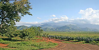
Makete District is one of the six districts of Njombe Region of Tanzania. Its administrative seat is the town of Iwawa. It is bordered to the north and west by the Mbeya Region, to the east by the Njombe District and to the south by the Ludewa District. It is divided into six divisions and 17 wards. Makete District was founded in 1979 with the policy of the Ujamaa. Before, this part of Iringa Region belonged to Njombe District. The district is known for growing apples due to the favorable climate.

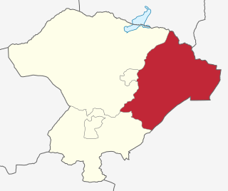
Kilosa District is one of the six districts of the Morogoro Region of Tanzania. Its administrative seat is the town of Kilosa. Kilosa District covers 14,918 square kilometres (5,760 sq mi). It is bordered to the north by the Manyara Region, to the northeast by the Tanga Region, to the east by Mvomero District, to the southeast by Morogoro Rural District, to the south by Kilombero District, to the southwest by the Iringa Region and to the west by the Dodoma Region. Kilosa District is home to Mikumi National Park.

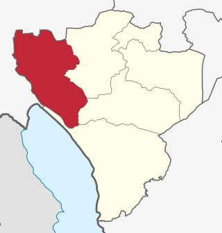
Morogoro Rural District is one of the six districts of the Morogoro Region of Tanzania. Morogoro Rural District covers 19,056 square kilometres (7,358 sq mi). It is bordered to the north and east by the Pwani Region, to the south by Kilombero District, to the southwest by the Kilosa District and to the west by the Mvomero District and the Morogoro Urban District.

Mbeya Rural District is one of the seven districts of Mbeya Region, Tanzania. It is bordered to the north by Mbarali District and Chunya District, to the south by Mbeya Urban District and Rungwe District, to the east by Iringa Region and to the west by Mbozi District.
Zanzibar West District is one of the two districts of the Zanzibar Urban/West Region of Tanzania. It is bordered to the north by the Zanzibar North Region, to the east by the Zanzibar Central/South Region, to the south by Kiwani Bay, and to the west by the Zanzibar Urban District.

Zanzibar City or Mjini District, often simply referred to as Zanzibar is one of two administrative districts of Mjini Magharibi Region in Tanzania. The district covers an area of 15.4 km2 (5.9 sq mi). The district is comparable in size to the land area of Nauru. The district has a water border to the west by the Indian Ocean. The district is bordered to the east by Magharibi District. The district seat is in Stonetown. The city is the largest on the island of Zanzibar. It is located on the west coast of Unguja, the main island of the Zanzibar Archipelago, north of the much larger city of Dar es Salaam across the Zanzibar Channel. The city also serves as the capital of the Zanzibar Urban/West Region. In 2022 its population was 219,007.
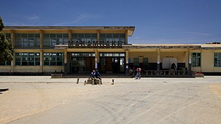
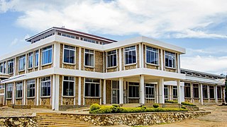
Makambako is a medium-sized town and district in the Njombe Region of the Tanzanian Southern Highlands, located roughly 40 miles north of Njombe city by road. It is located at junction of the A104 and B4 roads between Njombe, Iringa, and Mbeya. Its population according to the 2002 Tanzanian census was 51,049.
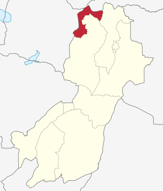
Wanging'ombe District is one of the six districts of the Njombe Region of Tanzania, East Africa. The administrative seat is in Igwachanya. According to the 2022 Tanzania National Census, the population of Igunga District was 191,506 in 2022.

Njombe Rural District is one of the six districts of the Njombe Region of Tanzania, East Africa. Its administrative seat is Njombe town. The 2022 population was 182,127.
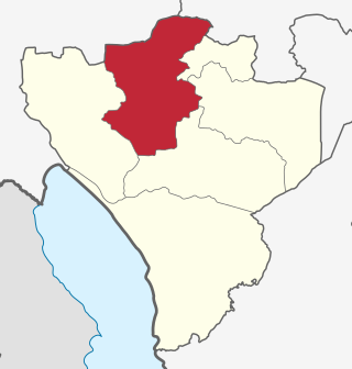
Gairo District is one of the seven districts of the Morogoro Region of Tanzania. It is located in the northwest corner of Morogoro Region. The administrative seat is in the town of Gairo. According to the 2022 Tanzania National Census, the population of Gairo District was 258,205 in 2022.

Morogoro Urban District is one of the six districts of the Morogoro Region of Tanzania. It contains the city Morogoro, capital of the Morogoro Region, and no villages. Morogoro Urban District covers 260 square kilometres (100 sq mi). It is bordered to the east and south by the Morogoro Rural District and to the north and west by Mvomero District
