
Iringa is a city in Tanzania with a population of 202,490 and situated at a latitude of 7.77°S and longitude of 35.69°E. The name is derived from the Hehe word lilinga, meaning fort. Iringa is the administrative capital of Iringa Region. Iringa Municipal Council is the administrative designation of the Municipality of Iringa. Iringa has been one of the coldest regions in Tanzania due to its geographical location but that has attracted a lot of tourists from colder regions abroad especially Western Europe. Iringa also hosts one of Africa’s largest national parks the Ruaha National Park.

Ludewa District is one of six districts in the Njombe Region in Tanzania, East Africa. Prior to 2012, the district was one of the seven districts of Iringa Region. The town of Ludewa is the administrative seat of the district. A hospital is located in the city. The district is bordered to the north by the Njombe Rural District and Makete District, to the southeast by the Ruvuma Region and to the southwest by the country of Malawi across Lake Nyasa.
Iringa Region is one of Tanzania's 31 administrative regions. The region covers an area of 35,503 km2 (13,708 sq mi). The region is comparable in size to the combined land area of the nation state of Guinea Bissau. Iringa Region is bordered to the east by Morogoro Region and south by Njombe Region. On the west the region is bordered by Mbeya Region. Dodoma Region and Singida Region border Iringa on the north. The regional capital is the city Iringa for which the city is named after. According to the 2022 census, the region has a total population of 1,192,728. Iringa Region is home to Ruaha National Park, Tanzania's second national largest park.

Mbeya Region is one of Tanzania's 31 administrative regions. The region covers an area of 35,954 km2 (13,882 sq mi). The region is comparable in size to the combined land area of the nation state of Guinea Bissau. Mbeya Region is bordered to the east by Singida Region, Iringa Region and Njombe Region. The region is bordered to the south by Malawi and Lake Nyasa. To the north the region borders southern Tabora Region. Lastly, Mbeya is bordered to the west by Songwe Region. The regional capital is the city of Mbeya. According to the 2022 national census, the region had a population of 2,343,754.

Mufindi District is one of the four districts of the Iringa Region of Tanzania. It is bordered to the north by Kilolo District and Iringa Urban District, to the south by the Njombe Region, to the east by the Morogoro Region and to the west by the Singida Region.

Njombe District is a former district of the Iringa Region of Tanzania. The current Njombe districts are Njombe Rural District and Njombe Urban District.

Tanzania faces generalized HIV epidemic which means it affects all sections of the society but also concentrated epidemic among certain population groups. The prevalence of HIV/AIDS in Tanzania is characterised by substantial across age, gender, geographical location and socioeconomic status implying difference in the risk of transmission of infection. In 2019, among 1.7 million people living with HIV/AIDS, the prevalence was 4.6% and 58,000 new HIV infection among 15–49 years old, and 6,500 new infections among children below 15 years old, 50% of all new infections are between 15 - 29 years of age group. Report from Tanzania PHIA of 2016/17 shows that HIV prevalence among women is higher (6.2%) than men (3.1%). The prevalence of HIV is less than 2% among 15-19 years for both males and females and then increases with age for both sexes.
The Kisi are a Bantu ethnolinguistic group from Makete District of Njombe Region, Tanzania, on the northwestern shore of Lake Malawi.

The Kinga are an ethnic and linguistic group native to Mbeya Region and Makete District of Njombe Region, Tanzania, in the great Kipengere Range northeast of Lake Malawi. In 2003 the Kinga population was estimated to number 140,000.
Stanley Jilaoneka Yono Kevela is a Member of Parliament in the National Assembly of Tanzania. Kevela was elected during the last Tansanian parliamentary elections in 2005 on the ticket of the governing Chama Cha Mapinduzi party and represents the Njombe West area of the Njombe District of the Iringa Region of the country. He has been quoted in the media as speaking in favor of increasing the level of higher education in the Njombe district and against stigmatising people with HIV/AIDS.

The following outline is provided as an overview of and topical guide to Tanzania:
Mgama is an administrative ward in the Iringa Rural district of the Iringa Region of Tanzania. In 2016 the Tanzania National Bureau of Statistics report there were 13,143 people in the ward, from 12,561 in 2012.

The 2010 maternal mortality rate per 100,000 births for Tanzania was 790. This is compared with 449 in 2008 and 610.2 in 1990. The UN Child Mortality Report 2011 reports a decrease in under-five mortality from 155 per 1,000 live births in 1990 to 76 per 1,000 live births in 2010, and in neonatal mortality from 40 per 1,000 live births to 26 per 1,000 live births. The aim of the report The State of the World's Midwifery is to highlight ways in which the Millennium Development Goals can be achieved, particularly Goal 4 – Reduce child
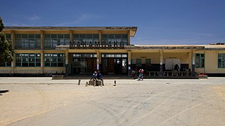
Makambako is a medium-sized town and district in the Njombe Region of the Tanzanian Southern Highlands, located roughly 40 miles north of Njombe city by road. It is located at junction of the A104 and B4 roads between Njombe, Iringa, and Mbeya. Its population according to the 2002 Tanzanian census was 51,049.
Wanging'ombe is a town and ward in Wanging'ombe District in the Njombe Region of the Tanzanian Southern Highlands. As of 2002, the population of the ward was 18,545.

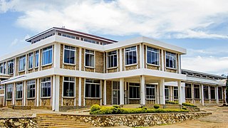
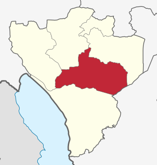
Njombe Region is one of Tanzania's 31 administrative regions. The region covers a land area of 21,347 km2 (8,242 sq mi). The region is comparable in size to the combined land area of the nation state of El Salvador. Njombe Region is bordered to the north by the Iringa Region and Mbeya Region, to the east by Morogoro Region, to the south by the Ruvuma Region and to the west by Lake Nyasa. The regional capital is the municipality of Njombe. According to the 2012 national census, the region had a population of 702,097.
Ninga is a town and ward in Njombe Rural District in the Njombe Region of the Tanzanian Southern Highlands. Ninga Ward was created since the 2002 Tanzanian census, so the first population reports for the ward will be for the 2012 census. The name Ninga comes from the Swahili word for dove, ninga.

Njombe Rural District is one of the six districts of the Njombe Region of Tanzania, East Africa. Its administrative seat is Njombe town. The 2022 population was 182,127.
Njombe Urban District is one of the six districts of the Njombe Region of Tanzania, East Africa. The administrative seat for the district is in the city of Njombe.
The Tanzanian Championship is the second tier of league football in Tanzania. The league is made up of sixteen teams that play thirty rounds, home and away.The league was formed in 1930.

