Noble, Iowa | |
|---|---|
 An aerial view of Noble, taken on July 1, 2025 | |
 Noble, Iowa | |
| Coordinates: 41°09′59″N91°37′11″W / 41.16639°N 91.61972°W | |
| Country | United States |
| State | Iowa |
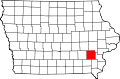
| County | Washington |
| Elevation | 689 ft (210 m) |
| Time zone | UTC-6 (Central (CST)) |
| • Summer (DST) | UTC-5 (CDT) |
| Area code | 319 |
| GNIS feature ID | 459531 [1] |
Noble is an unincorporated community in Washington County, Iowa, United States. [1]