The Chattahoochee River forms the southern half of the Alabama and Georgia border, as well as a portion of the Florida - Georgia border. It is a tributary of the Apalachicola River, a relatively short river formed by the confluence of the Chattahoochee and Flint rivers and emptying from Florida into Apalachicola Bay in the Gulf of Mexico. The Chattahoochee River is about 430 miles (690 km) long. The Chattahoochee, Flint, and Apalachicola rivers together make up the Apalachicola–Chattahoochee–Flint River Basin. The Chattahoochee makes up the largest part of the ACF's drainage basin.
North Branch may refer to:

The West Branch Susquehanna River is one of the two principal branches, along with the North Branch, of the Susquehanna River in the northeastern United States. The North Branch, which rises in upstate New York, is generally regarded as the extension of the main branch, with the shorter West Branch being its principal tributary. The West Branch, which is 243 miles (391 km) long, is entirely within the state of Pennsylvania, draining a large mountainous area within the Allegheny Plateau in the western part of the state. Along most of its course it meanders along mountain ridges and through water gaps, forming a large zigzag arc through central Pennsylvania around the north end of the Allegheny Ridge. In colonial times the river provided an important water route to the Ohio River valley. In the 18th century, its lower valley became a significant industrial heartland of Pennsylvania. In the 20th century, the upper reaches of the West Branch turned a yellow/orange color due to sulfurous drainage from nearby and abandoned deep bituminous coal mines.

Rock Creek is a free-flowing tributary of the Potomac River that empties into the Atlantic Ocean via the Chesapeake Bay. The 32.6-mile (52.5 km) creek drains about 76.5 square miles (198 km2). Its final quarter-mile is affected by tides.

The Choptank River is a major tributary of the Chesapeake Bay and the largest river on the Delmarva Peninsula. Running for 71 miles (114 km), it rises in Kent County, Delaware, runs through Caroline County, Maryland and forms much of the border between Talbot County, Maryland on the north, and Caroline County and Dorchester County on the east and south. It is located north of the Nanticoke River and its mouth is located south of Eastern Bay. Cambridge, the county seat of Dorchester County, and Denton, the county seat of Caroline County, are located on its south shore.

The Severn River is a tidal estuary 14 miles (23 km) long, located in Anne Arundel County in the U.S. state of Maryland, south of the Magothy River and north of the South River.
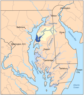
The Chester River is a major tributary of the Chesapeake Bay on the Delmarva Peninsula. It is about 43 miles (69 km) long, and its watershed encompasses 368 sq mi (950 km2), which includes 295 sq mi (760 km2) of land. Thus the total watershed area is 20% water. It forms the border between Kent County and Queen Anne's County, Maryland, with its headwaters extending into New Castle County and Kent County, Delaware. Chestertown, the seat of Maryland's Kent County, is located on its north shore. It is located south of the Sassafras River and north of Eastern Bay, and is connected with Eastern Bay through Kent Narrows.

Mill Creek is a 14.0-mile-long (22.5 km) tributary stream of the South Branch Potomac River, belonging to the Potomac River and Chesapeake Bay watersheds. The stream is located in Hampshire County in West Virginia's Eastern Panhandle. Mill Creek flows into the South Branch west of Romney Bridge near Vanderlip along the Northwestern Turnpike.

Goose Creek is a 53.9-mile-long (86.7 km) tributary of the Potomac River in Fauquier and Loudoun counties in northern Virginia. It comprises the principal drainage system for the Loudoun Valley.
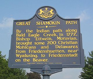
The Great Shamokin Path was a major Native American trail in the U.S. State of Pennsylvania that ran from the native village of Shamokin along the left bank of the West Branch Susquehanna River north and then west to the Great Island. There it left the river and continued further west to Chinklacamoose and finally Kittanning on the Allegheny River.

Octoraro Creek is a 22.1-mile-long (35.6 km) tributary of the Susquehanna River, joining it 9 miles (14 km) above the Susquehanna's mouth at Chesapeake Bay. The Octoraro rises as an East and West Branch in Pennsylvania. The East Branch and Octoraro Creek form the southern half of the border between Lancaster and Chester counties until the creek crosses the Mason-Dixon line. It winds through northwestern Cecil County, Maryland before joining the Susquehanna.
Chopawamsic Creek is a 6.8-mile-long (10.9 km) tributary of the Potomac River in Prince William and Stafford counties, Virginia. Chopawamsic Creek is formed by the confluence of the North and South Branches of Chopawamsic Creek and empties into the Potomac River south of Quantico at the Marine Corps Base Quantico's Air Station. Breckenridge Reservoir lies at the stream's confluence with the North and South Branches. Along with its North Branch, Chopawamsic Creek forms part of the boundary between Prince William and Stafford counties. The North Branch flows through part of the Chopawamsic Backcountry Area in Prince William Forest Park.

The Coosawattee River is a 49.3-mile-long (79.3 km) river located in the northwestern Georgia, United States.
Mahantango Creek is a 2.1-mile-long (3.4 km) tributary of the Susquehanna River in Snyder and Juniata counties, Pennsylvania, in the United States. Its name comes from a Delaware Indian word meaning "where we had plenty to eat". The creek flows along the border between Snyder County and Juniata County.

Hoffman Brook is a river in Delaware County, New York. It flows into North Branch Basket Creek north-northeast of Basket.
Basket Pond is a small lake north-northwest of Rock Valley in Delaware County, New York. It drains south via an unnamed creek which flows into the North Branch Basket Creek.