The Caribbean Sea is a sea of the Atlantic Ocean in the tropics of the Western Hemisphere. It is bounded by Mexico and Central America to the west and southwest, to the north by the Greater Antilles starting with Cuba, to the east by the Lesser Antilles, and to the south by the northern coast of South America. The Gulf of Mexico lies to the northwest.
Nicaragua is a country in Central America, bordering both the Caribbean Sea and the North Pacific Ocean, between Costa Rica and Honduras. Nicaragua is the largest country in Central America in square kilometers.
The overseas departments and regions of France are departments of the French Republic which are outside the continental Europe situated portion of France, known as "metropolitan France". The distant parts have exactly the same status as mainland France's regions and departments. The French Constitution provides that, in general, French laws and regulations apply to French overseas regions the same as in metropolitan France, but can be adapted as needed to suit the region's particular needs. Hence, the local administrations of French overseas regions cannot themselves pass new laws. On occasion referendums are undertaken to re-assess the sentiment in local status.

Nicaragua is a unitary republic, divided for administrative purposes into fifteen departments and two autonomous regions.

Zelaya is a former department in Nicaragua. The department was located along the Mosquito Coast bordering the Caribbean Sea and was named after former President of Nicaragua José Santos Zelaya, who conquered the region for Nicaragua from the Mosquito Coast, then a British protectorate and indigenous monarchy, in 1894. The capital was Bluefields.

The North Caribbean Coast Autonomous Region is one of two autonomous regions in Nicaragua. It was created along with the South Caribbean Coast Autonomous Region by the Autonomy Statute of 7 September 1987 through a division of the former Zelaya Department. It covers an area of 33,106 km2 and has a population of 541,189. It is the largest autonomous region or department in Nicaragua. The capital is Puerto Cabezas. It contains part of the region known as the Mosquito Coast.
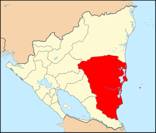
The South Caribbean Coast Autonomous Region is one of two autonomous regions in Nicaragua. It was created along with the North Caribbean Coast Autonomous Region by the Autonomy Statute of 7 September 1987 through a division of the former Zelaya Department. It covers an area of 27,260 km2 (10,530 sq mi) and has a population of 420,935. The capital is Bluefields. Bordering the Caribbean Sea, it contains part of the region known as Mosquitia.

Bluefields is the capital of the South Caribbean Autonomous Region in Nicaragua. It was also the capital of the former Kingdom of Mosquitia, and later the Zelaya Department, which was divided into North and South Caribbean Coast Autonomous Regions. It is located on Bluefields Bay at the mouth of the Bluefields River in the municipality of the same name.
Mískito Coast Creole or Nicaraguan Creole English is an English-based creole language spoken in coastal Nicaraguan region of Mosquito Coast on the Caribbean Sea; its approximately 40,000 speakers are spread over the RAAN and RAAS regions of Nicaragua. The region, known before 1986 as the Zelaya department, is today administratively separated into two autonomous regions: North Caribbean Coast (RAAN) and South Caribbean Coast (RAAS). Mosquito is the nickname that is given to the region and earlier residents by early Europeans who visited and settled in the area. The term "Miskito" is now more commonly used to refer to both the people and the language.

Prinzapolka is a Miskito municipality in the North Caribbean Coast Autonomous Region of Nicaragua.

Pearl Lagoon is a municipality that is often time called just Lagoon and was historically known as English Bank. It is located in the South Caribbean Coast Autonomous Region of Nicaragua. It is the most important town of the largest coastal lagoon also by the name of Pearl Lagoon in the South Caribbean Coast Autonomous Region of Nicaragua and which the name of the town is derived from. As of 2022, Pearl Lagoon Municipality had a population of 21,360.

Cabo Gracias a Dios is a cape located in the middle of the east coast of Central America, within what is variously called the Mosquito Coast and La Mosquitia. It is the point where the Rio Coco flows into the Caribbean, and is the border between the Nicaraguan North Caribbean Coast Autonomous Region and the Honduran department also known as Gracias a Dios.
Puerto Cabezas Airport is an airport serving Puerto Cabezas, North Caribbean Coast Autonomous Region. It is located approximately one hour from Managua by aircraft. Operated by the state of Nicaragua, it mainly serves the city of Puerto Cabezas and Bluefields located close to the northeast corner of the country.

The Miskito Cays are an archipelago with an area of 27 km2 located off shore in the northeastern Caribbean coast of Nicaragua, part of the North Caribbean Coast Autonomous Region. The Miskito Cays are composed of 76 formations that include estuaries, coral reefs, cays, seagrass beds, and islets, of which 12 of the formations are covered with vegetation and consequently form islands which are lined with white sand beaches.

The Caribbean is a subregion of the Americas that includes the Caribbean Sea and its islands, some of which are surrounded by the Caribbean Sea and some of which border both the Caribbean Sea and the North Atlantic Ocean; the nearby coastal areas on the mainland are often also included in the region. The region is southeast of the Gulf of Mexico and the North American mainland, east of Central America, and north of South America.
The University of the Autonomous Regions of the Nicaraguan Caribbean Coast, is a university founded in 1994. It is described as an "intercultural university community for indigenous peoples and ethnic communities".
The Tuma River is a river located in Nicaragua. The length of the Tuma is 180 kilometres (110 mi).

The Dutch Caribbean are the territories, colonies, and countries, former and current, of the Dutch Empire and the Kingdom of the Netherlands in the Caribbean Sea. They are in the north and south-west of the Lesser Antilles archipelago.
Settlement of English people along the Caribbean Coast, or Miskito Coast, of Nicaragua began in 1633. The area was controlled by Britain until 1860, and eventually integrated into Nicaragua by 1894. The Miskito Coast region divided into two autonomous regions within Nicaragua after 1987.
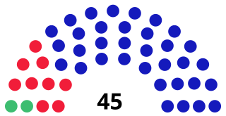
The South Caribbean Coast Autonomous Regional Council is the devolved legislature of the South Caribbean Coast Autonomous Region. It has the power to legislate on a wide variety of economic, social, and cultural issues not reserved to the central government. The council has the same power as the North Caribbean Coast Autonomous Regional Council.