The Driftless Area, also known as Bluff Country, the Paleozoic Plateau, and the Coulee Region, is a topographical and cultural region in the Midwestern United States that comprises southwestern Wisconsin, southeastern Minnesota, northeastern Iowa, and the extreme northwestern corner of Illinois. The Driftless Area is a USDA Level III Ecoregion: Ecoregion 52. The Driftless Area takes up a large portion of the Upper Midwest Forest-Savanna Transition ecotone.

The Laurentian Mixed Forest Province, also known as the North Woods, is a forested ecoregion in eastern North America. Among others, this terminology has been adopted by the Minnesota Department of Natural Resources. Similar, though not necessarily entirely identical regions, are identified by the United States Environmental Protection Agency as Northern Lakes and Forests, and by the World Wildlife Fund by regions such as the Western Great Lakes forests and Eastern forest-boreal transition.
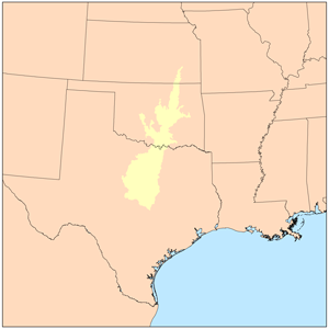
The term Cross Timbers, also known as Ecoregion 29, Central Oklahoma/Texas Plains, is used to describe a strip of land in the United States that runs from southeastern Kansas across Central Oklahoma to Central Texas. Made up of a mix of prairie, savanna, and woodland, it forms part of the boundary between the more heavily forested eastern country and the almost treeless Great Plains, and also marks the western habitat limit of many mammals and insects.

The Straight River is a tributary of the Fish Hook River, 23 miles (37 km) long, in north-central Minnesota in the United States. Via the Fish Hook, Shell, and Crow Wing Rivers, it is part of the watershed of the Mississippi River, draining an area of approximately 60 square miles (160 km2) in a rural region. The river is known as one of Minnesota's best trout fishing streams.

The Blueberry River is a tributary of the Shell River, approximately twenty miles (30 km) long, in north-central Minnesota in the United States. Via the Shell and Crow Wing Rivers, it is part of the watershed of the Mississippi River, draining a rural area.
The Kettle River, also known as Kettle Creek, is a tributary of the Blueberry River, 17 miles (28 km) long, in north-central Minnesota in the United States. Via the Blueberry, Shell, and Crow Wing Rivers, it is part of the watershed of the Mississippi River, draining a rural area.

The Western Great Lakes forests is a terrestrial ecoregion as defined by the World Wildlife Fund. It is within the temperate broadleaf and mixed forests biome of North America. It is found in northern areas of the United States' states of Michigan, Wisconsin and Minnesota, and in southern areas of the Canadian province of Manitoba and northwestern areas of the province of Ontario.

The Mississippi Alluvial Plain is a Level III ecoregion designated by the Environmental Protection Agency (EPA) in seven U.S. states, though predominantly in Arkansas, Louisiana, and Mississippi. It parallels the Mississippi River from the Midwestern United States to the Gulf of Mexico.

The Arkansas Valley is a Level III ecoregion designated by the Environmental Protection Agency (EPA) in the U.S. states of Arkansas and Oklahoma. It parallels the Arkansas River between the flat plains of western Oklahoma and the Arkansas Delta, dividing the Ozarks and the Ouachita Mountains with the broad valleys created by the river's floodplain, occasionally interrupted by low hills, scattered ridges, and mountains. In Arkansas, the region is often known as the Arkansas River Valley, especially when describing the history and culture of the region.

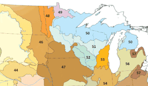
The Northern Lakes and Forests are an ecoregion in northern Minnesota, northern Wisconsin, and northern Michigan in the United States. It is a Level III ecoregion in the United States Environmental Protection Agency's (EPA's) classification system, where it is designated as ecoregion number 50. The ecoregion is characterized by coniferous and northern hardwoods forests, morainal hills, large lake basins, and broad areas of sandy outwash plains, with numerous lakes and wetlands. The Northern Lakes and Forests are less well-suited to agriculture than ecoregions to the south, owing to shorter growing seasons, lower temperatures, and soils formed mainly from nutrient-poor sandy and loamy glacial drift material.
The Southeastern Wisconsin Till Plains is an ecoregion in southeastern Wisconsin and northeastern Illinois in the United States. It is a Level III ecoregion in the classification system of the United States Environmental Protection Agency (EPA), where it is designated as ecoregion number 53. The ecoregion represents a transition between the hardwood forests and oak savannas to the west and the tallgrass prairie ecoregions to the south; it is today mostly covered by cropland.

The Western Corn Belt Plains is a Level III ecoregion designated by the Environmental Protection Agency (EPA) in seven U.S. states, though predominantly in Iowa.

The Northeastern Highlands ecoregion is a Level III ecoregion designated by the United States Environmental Protection Agency (EPA) in the U.S. states of Vermont, New Hampshire, Massachusetts, Maine, Connecticut, New York, New Jersey, and Pennsylvania. The ecoregion extends from the northern tip of Maine and runs south along the Appalachian Mountain Range into eastern Pennsylvania. Discontiguous sections are located among New York's Adirondack Mountains and the Catskill Range. The largest portion of the Northeastern Highlands ecoregion encompasses several sub mountain ranges including the Berkshires, Green Mountains, Taconic, and White Mountains.
The Northern Minnesota Wetlands ecoregion is a Level III ecoregion designated by the United States Environmental Protection Agency (EPA) in northern Minnesota in the United States. Designated as ecoregion number 49, the ecoregion is sparsely populated and generally features conifer bog, mixed forest, and boreal forest vegetation. Much of the Northern Minnesota Wetlands is covered by standing water although some low-gradient streams and rivers occur in the eastern part; lakes in the region tend to have lower phosphorus and algae concentrations than some other parts of the state due to an abundance of forests and less agriculture.