
The South Platte River is one of the two principal tributaries of the Platte River. Flowing through the U.S. states of Colorado and Nebraska, it is itself a major river of the American Midwest and the American Southwest/Mountain West. Its drainage basin includes much of the eastern flank of the Rocky Mountains in Colorado, much of the populated region known as the Colorado Front Range and Eastern Plains, and a portion of southeastern Wyoming in the vicinity of the city of Cheyenne. It joins the North Platte River in western Nebraska to form the Platte, which then flows across Nebraska to the Missouri. The river serves as the principal source of water for eastern Colorado. In its valley along the foothills in Colorado, it has permitted agriculture in an area of the Colorado Piedmont and Great Plains that is otherwise arid.

The willow flycatcher is a small insect-eating, neotropical migrant bird of the tyrant flycatcher family native to North America.

The Gila River is a 649-mile-long (1,044 km) tributary of the Colorado River flowing through New Mexico and Arizona in the United States. The river drains an arid watershed of nearly 60,000 square miles (160,000 km2) that lies mostly within the U.S., but also extends into northern Sonora, Mexico.
The Canadian River is the longest tributary of the Arkansas River in the United States. It is about 1,026 miles (1,651 km) long, starting in Colorado and traveling through New Mexico, the Texas Panhandle, and Oklahoma. The drainage area is about 47,700 square miles (124,000 km2).
The Rio Chama, a major tributary river of the Rio Grande, is located in the U.S. states of Colorado and New Mexico. The river is about 130 miles (210 km) long altogether. From its source to El Vado Dam its length is about 50 miles (80 km), from El Vado Dam to Abiquiu Dam is about 51 miles (82 km), and from Abiquiu Dam to its confluence with the Rio Grande is about 34 miles (55 km).

The Raton Basin is a geologic structural basin in southern Colorado and northern New Mexico. It takes its name from Raton Pass and the town of Raton, New Mexico. In extent, the basin is approximately 50 miles (80 km) east-west, and 90 miles (140 km) north-south, in Huerfano and Las Animas Counties, Colorado, and Colfax County, New Mexico.

Boulder Creek is a 31.4-mile-long (50.5 km) creek draining the Rocky Mountains to the west of Boulder, Colorado, as well as the city itself and surrounding plains.

The Maxwell Land Grant, also known as the Beaubien-Miranda Land Grant, was a 1,714,765-acre (6,939.41 km2) Mexican land grant in Colfax County, New Mexico, and part of adjoining Las Animas County, Colorado. This 1841 land grant was one of the largest contiguous private landholdings in the history of the United States. The New Mexico communities of Cimarron, Dawson, Elizabethtown, Baldy Town, Maxwell, Miami, Raton, Rayado, Springer, Ute Park and Vermejo Park came to be located within the grant, as well as numerous places that are now ghost towns.

Vermejo Park Ranch, Vermejo Ranch, or Vermejo, is a 550,000-acre (220,000 ha) nature reserve and guest ranch in northeastern New Mexico and southern Colorado. Ted Turner Reserves, the luxury hospitality company founded by Ted Turner, includes conservation research and ecosystem restoration along with guest operations. The reserve, which stretches from the Great Plains at an elevation of 5,867 ft (1,788 m) to the summit of the Sangre de Cristo Mountains, reaches an elevation of 12,931 ft (3,941 m). The ranch produces significant quantities of coalbed methane, a type of natural gas.
The Vermejo Formation is a geologic formation of Upper Cretaceous age. It outcrops in the Raton Basin of northeastern New Mexico and southern Colorado.

The Puerco River or Rio Puerco is a tributary of the Little Colorado River in northwestern New Mexico and northeastern Arizona. It flows through arid terrain, including the Painted Desert.
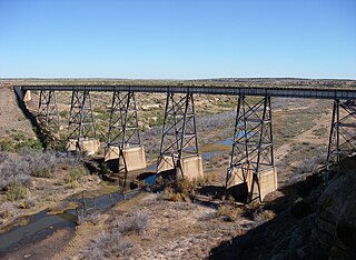
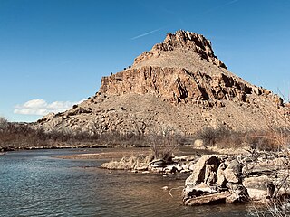
Vermejo River is a tributary of the Canadian River in Colfax County, New Mexico. The river flows southeast from the confluence of North Fork Vermejo River and Little Vermejo Creek to a confluence with the Canadian River south of Maxwell. The upper course of the Vermejo flows through Vermejo Park Ranch, one of the largest ranches in the U.S. and now devoted primarily to recreation such as fishing and hunting.

The Williams Fork is a tributary of the Colorado River, approximately 33.8 miles (54.4 km) long, in north central Colorado in the United States. It flows through Grand County between the valleys of the Fraser River and the Blue River. It rises at the juncture of McQueary and Bobtail creeks just west of the Continental Divide 8 miles (13 km) west of Berthoud Pass and 7 miles (11 km) north of the Eisenhower Tunnel in the Arapaho National Forest. It flows north-northwest to the Williams Fork Reservoir, then turns northeast and joins the Colorado at Parshall.

Costilla Creek is a tributary of the Rio Grande in Colorado and New Mexico.
Iyanbito is an unincorporated community and census-designated place (CDP) in McKinley County, New Mexico, United States, on the Navajo Nation. As of the 2020 census, it had a population of 1,193.
