
Avebury is a village and civil parish in Wiltshire, England. The village is about 5.5 miles (9 km) west of Marlborough and 8 miles (13 km) northeast of Devizes. Much of the village is encircled by the prehistoric monument complex also known as Avebury. The parish also includes the small villages of Avebury Trusloe and Beckhampton, and the hamlet of West Kennett.

Kelmscott Manor is a limestone manor house in the Cotswolds village of Kelmscott, in West Oxfordshire, southern England. It dates from around 1570, with a late 17th-century wing, and is listed Grade I on the National Heritage List for England. It is situated close to the River Thames. The nearest town is Lechlade-On-Thames.

Chicheley Hall, Chicheley, Buckinghamshire, England is a country house built in the first quarter of the 18th century. The client was Sir John Chester, the main architect was Francis Smith of Warwick and the architectural style is Baroque. Later owners included David Beatty, 2nd Earl Beatty and the Royal Society. Chicheley Hall is a Grade I listed building.

Brinkburn Priory is a former monastery built, starting in the 12th century, on a bend of the River Coquet, about 4 miles (6 km) east of Rothbury, Northumberland, England.
Barrington Court is a Tudor manor house begun around 1538 and completed in the late 1550s, with a vernacular stable court (1675), situated in Barrington, near Ilminster, Somerset, England.

Dodington Park is a country house and estate in Dodington, South Gloucestershire, England. The house was built by James Wyatt for Christopher Bethell Codrington. The family had made their fortune from sugar plantations in the Caribbean and were significant owners of slaves. It remained in the Codrington family until 1980; it is now owned by the British businessman James Dyson.

Norton-sub-Hamdon is a village and civil parish in the South Somerset district of the English county of Somerset, situated ten miles west of Yeovil. The village has a population of 743.

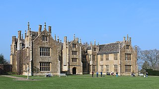
Stoke sub Hamdon Priory is a complex of buildings and ruins which initially formed a 14th-century college for the chantry chapel of St Nicholas, and later was the site of a farm in Stoke-sub-Hamdon, Somerset, England. The only building remaining from the college is a great hall and attached dwelling, dating from the late 15th century. The hall is designated by English Heritage as a Grade I listed building, while the outbuildings and gateway are Grade II listed. The whole site has been scheduled as an ancient monument. A number of the farm buildings are in poor condition, and have been added to the Heritage at Risk Register.

Redlynch is a village and former manor in the civil parish of Bruton, in the South Somerset district of Somerset, England. The 18th-century church and a folly named The Towers are of architectural interest.

North Perrott is a village and civil parish in south Somerset, England, near the border with Dorset.

Wigborough Manor House is a manor house in South Petherton, Somerset, England. It was partly built in 1585, although it was never completed to the original designs and was subsequently modified. It has been designated as a Grade I listed building.

Shotwick Hall is a former manor house in the village of Shotwick, Cheshire, England. It replaced an earlier manor house that stood on a moated site some 150 metres to the west. The hall and four associated structures are listed buildings, and the moated site is a Scheduled Monument.

Boughton Monchelsea Place, previously Boughton Court, is a 16th-century country house in Boughton Monchelsea, Kent, England. The first part of the house was built by Robert Rudston circa 1567–75 on the site of an earlier manor house. It has been modified a number of times during its history achieving its present form in 1819. It has been a home to a number of members of parliament for Maidstone or for Kent, including Sir Francis Barnham, Sir Robert Barnham (1646–85) Sir Barnham Rider (1698–1728) and Thomas Rider (1805–47).
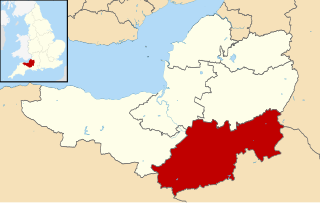
South Somerset is a local government district in the English county of Somerset. The South Somerset district occupies an area of 370 square miles (958 km2), stretching from its borders with Devon and Dorset to the edge of the Somerset Levels. The district has a population of about 158,000, and has Yeovil as its administrative centre.

Taunton Deane is a local government district with borough status in the English county of Somerset. In the United Kingdom, the term listed building refers to a building or other structure officially designated as being of special architectural, historical or cultural significance; Grade II* structures are those considered to be "particularly significant buildings of more than local interest". Listing was begun by a provision in the Town and Country Planning Act 1947. Once listed, severe restrictions are imposed on the modifications allowed to a building's structure or its fittings. In England, the authority for listing under the Planning Act 1990 rests with Historic England, a non-departmental public body sponsored by the Department for Digital, Culture, Media and Sport; local authorities have a responsibility to regulate and enforce the planning regulations.

Abbotswood is a country house and estate near Lower Swell in Gloucestershire, England. It is a grade II listed building and estate, of medieval origins and with remodelling and garden work to the designs of Sir Edwin Lutyens from 1901 onwards.

Chard Prep School is a coeducational private school for children ages 4 to 11 located in the town of Chard in the English county of Somerset.
Moreton Corbet and Lee Brockhurst is a civil parish in Shropshire, England. It contains 45 listed buildings that are recorded in the National Heritage List for England. Of these, three are listed at Grade I, the highest of the three grades, two are at Grade II*, the middle grade, and the others are at Grade II, the lowest grade. The parish contains the villages and smaller settlements of Acton Reynald, Moreton Corbet, Lee Brockhurst, and Preston Brockhurst, and the surrounding countryside. Most of the listed buildings are houses and cottages, farmhouses and farm buildings and associated structures, the earliest of which are timber framed. The other listed buildings include churches, memorials, a ruined castle and mansion, country houses and associated structures, a former watermill, a bridge, and two mileposts.
Sutton upon Tern is a civil parish in Shropshire, England. It contains 24 listed buildings that are recorded in the National Heritage List for England. Of these, four are listed at Grade II*, the middle of the three grades, and the others are at Grade II, the lowest grade. The parish contains the village of Sutton upon Tern and is otherwise largely rural. The Shropshire Union Canal passes through the parish, and the listed buildings associated with it are two bridges and a milepost. In the parish are the country houses Buntingsdale Hall and Pell Wall, and another large house, Colehurst Manor, which are listed together with associated structures. The other listed buildings are farmhouses, farm buildings, a road bridge, a milestone, and a coach house and stables.

Todenham is a village and civil parish in the Cotswold district of Gloucestershire, England. The village is significant for its Grade I listed 14th-century parish church.

