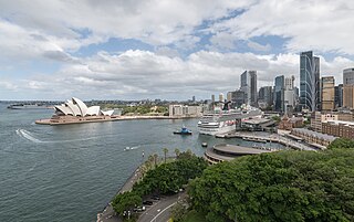
Circular Quay is a harbour, former working port and now international passenger shipping terminal, public piazza and tourism precinct, heritage area, and transport node located in Sydney, New South Wales, Australia on the northern edge of the Sydney central business district on Sydney Cove, between Bennelong Point and The Rocks. It is part of the local government area of the City of Sydney.

Macquarie Harbour is a shallow fjord in the West Coast region of Tasmania, Australia. It is approximately 315 square kilometres (122 sq mi), and has an average depth of 15 metres (49 ft), with deeper places up to 50 metres (160 ft). It is navigable by shallow-draft vessels. The main channel is kept clear by the presence of a rock wall on the outside of the channel's curve. This man-made wall prevents erosion and keeps the channel deep and narrow, rather than allowing the channel to become wide and shallow. A reported Aboriginal name for the harbour is Parralaongatek.

Port Macquarie, locally nicknamed Port, is a coastal city in the local government area of Port Macquarie-Hastings. It is located on the Mid North Coast of New South Wales, Australia, about 390 km (242 mi) north of Sydney, and 570 km (354 mi) south of Brisbane. The city is located on the Tasman Sea coast, at the mouth of the Hastings River, and at the eastern end of the Oxley Highway (B56). The city with its suburbs had a population of 47,974 in June 2018 and an estimated population of 50,307 in June 2023.

Longueville is a prestigious affluent harbourside suburb on the Lower North Shore of Sydney, New South Wales, 8 kilometres north of the Sydney central business district, in the local government area of the Municipality of Lane Cove.

Sullivans Cove is on the River Derwent adjacent to the Hobart City Centre in Tasmania. It was the site of initial European settlement in the area, and the location of the earlier components of the Port of Hobart.

The Sydney central business district (CBD) is the historical and main commercial centre of Sydney. The CBD is Sydney's city centre, or Sydney City, and the two terms are used interchangeably. Colloquially, the CBD or city centre is often referred to simply as "Town" or "the City". The Sydney city centre extends southwards for about 3 km (2 mi) from Sydney Cove, the point of first European settlement in which the Sydney region was initially established.

Marsfield is a suburb in the Northern Sydney region of Sydney, in the state of New South Wales, Australia. Marsfield is located 16 kilometres north-west of the Sydney central business district in the local government area of the City of Ryde.

Wauchope ( ) is a town in the Mid North Coast region of New South Wales, Australia. It is within the boundaries of the Port Macquarie-Hastings Council area. Wauchope is inland on the Hastings River and the Oxley Highway 19 km (12 mi) west of Port Macquarie. The town is 383 km (238 mi) north of the state capital Sydney.

McMahons Point is a harbourside suburb on the lower North Shore of Sydney, New South Wales, Australia. McMahons Point is located 3 kilometres north of the Sydney central business district, in the local government area of North Sydney Council. McMahons Point sits on the peninsula flanked by Berrys Bay to the west and Lavender Bay to the east. The lower tip of the peninsula is known as Blues Point, which offers expansive views of Port Jackson. The postcode is 2060.

Port Macquarie-Hastings Council is a local government area in the Mid North Coast region of New South Wales, Australia.
Lake Cathie is a town in New South Wales, Australia about 15 minutes drive south of Port Macquarie. At the 2021 census, it had a population of 4,296.
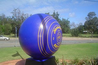
Speers Point is a suburb of Greater Newcastle, and the location of the council seat of the City of Lake Macquarie local government area in New South Wales, Australia. It is 17 kilometres (10.6 mi) west-southwest of the city of Newcastle on the northern shore of Lake Macquarie, in Cockle and Warners Bays, between the suburbs of Cardiff and Warners Bay.

Tascott is a suburb of the Central Coast region of New South Wales, Australia between Gosford and Woy Woy on Brisbane Water's western shore. It is part of the Central Coast Council local government area.
Austins Ferry is a residential locality in the local government area (LGA) of Glenorchy in the Hobart LGA region of Tasmania. The locality is about 9 kilometres (5.6 mi) north of the town of Glenorchy. The 2021 census recorded a population of 2,395 for Austins Ferry. It is a suburb of Hobart.
Lawrence is a small town 13 km from Maclean, New South Wales, Australia. It is accessed by the Lawrence car ferry from Woodford Island or by travelling 30 kilometres north from Grafton. At the 2021 census, the population of Lawrence was 925.
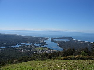
Camden Haven is a parish in the Mid North Coast region of New South Wales, Australia, approximately 30 km south of the major regional centre of Port Macquarie. The harbour is located where the Camden Haven River empties into the Tasman Sea.

Ellenborough is a parish and village straddling the Oxley Highway and the Ellenborough River, less than one kilometre south of its confluence with the Hastings River. The village is about 38 km west of Wauchope and approximately 130 km east of Walcha. The boundaries are within the Port Macquarie-Hastings Council and Macquarie County.

Long Flat is a rural village situated on the Oxley Highway and the southern bank of the Hastings River. This village is about 50 kilometres west of Port Macquarie, 30 kilometres west of Wauchope and 133 km east of Walcha. The boundaries are within the Port Macquarie-Hastings Council Local Government Area and Macquarie County.

Rollands Plains is a village and bounded rural locality in Mid North Coast of New South Wales, Australia.
The Hatch is a rural suburb of Port Macquarie, a city in New South Wales.


