
Teesside is a built-up area around the River Tees in North East England, split between County Durham and North Yorkshire. The area contains the towns of Middlesbrough, Stockton-on-Tees, Billingham, Redcar, Thornaby-on-Tees, and Ingleby Barwick. Teesside's economy was once dominated by heavy manufacturing until deindustrialisation in the latter half of the 20th century. Chemical production continues to contribute significantly to Teesside's economy.

Kilton Thorpe is a village in the borough of Redcar and Cleveland and the ceremonial county of North Yorkshire, England. Noted for evidence of early settlement. The outlines of an ancient village are visible in fields adjacent to the present village.

North Skelton is a village in Redcar and Cleveland, North Yorkshire, England.

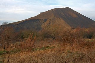
The Cleveland Hills are a range of hills on the north-west edge of the North York Moors in North Yorkshire, England, overlooking Cleveland and Teesside. They lie entirely within the boundaries of the North York Moors National Park. Part of the 110-mile (177 km) long Cleveland Way National Trail runs along the hills, and they are also crossed by a section of Wainwright's Coast to Coast Walk. The hills, which rise abruptly from the flat Tees Valley to the north, include distinctive landmarks such as the cone-shaped peak of Roseberry Topping, near the village of Great Ayton – childhood home of Captain James Cook.

Lockwood is a civil parish in the unitary authority of Redcar and Cleveland with ceremonial association with North Yorkshire, England. The population of Lockwood ward in the Redcar and Cleveland Unitary authority taken at the 2011 census was 2,022.
The Rosedale Railway was a 19.5-mile (31.4 km) goods-only railway line running from Battersby Junction via Ingleby Incline, across the heights of the North York Moors in North Yorkshire, England to reach iron ore deposits in the remote hills of the Rosedale valley. It opened to traffic as a narrow gauge railway to Ingleby Incline top in 1858, converted to standard gauge and opened to Rosedale West in 1861, and closed completely in 1929. Apart from Ingleby Incline, no major engineering works were constructed, and as such, particularly the east branch, the railway followed the contours of the surrounding hillside. The former trackbeds of the railway are in use by walkers and cyclists.

The Cleveland Ironstone Formation is a sequence of marine ironstone seams interbedded with shale and siltstone units which collectively form a part of the Lower Jurassic System of rocks underlying Cleveland in North Yorkshire. Exploitation of the ironstone seams became a major driving force behind the industrialisation of the Teesside district during the mid- to late-1800s.

Bolckow, Vaughan & Co., Ltd was an English ironmaking and mining company founded in 1864, based on the partnership since 1840 of its two founders, Henry Bolckow and John Vaughan. The firm drove the dramatic growth of Middlesbrough and the production of coal and iron in the north-east of England in the 19th century. The two founding partners had an exceptionally close working relationship which lasted until Vaughan's death.

John Marley was an English mining engineer from Darlington who together with ironmaster John Vaughan made the "commercial discovery" of the Cleveland Ironstone Formation, the basis of the wealth of their company Bolckow Vaughan and the industrial growth of Middlesbrough. He was an effective leader of engineering operations at Bolckow Vaughan's mines and collieries. He ended his career as a wealthy independent mine-owner and president of the North of England Institute of Mining and Mechanical Engineers (NEIMME).

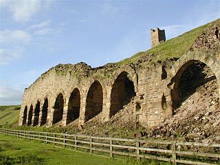
Grinkle Mine, was an ironstone mine working the main Cleveland Seam near to Roxby in North Yorkshire, England. Initially, the ironstone was mined specifically for the furnaces at the Palmer Shipbuilders in Jarrow on the River Tyne, but later, the mine became independent of Palmers. To enable the output from the mine to be exported, a 3-mile (4.8 km) narrow-gauge tramway was constructed that ran across three viaducts and through two tunnels to the harbour of Port Mulgrave, where ships would take the ore directly to Tyneside.

Roseberry Mine was an ironstone mine in the North Riding of Yorkshire, England, which operated between 1883 and 1924, with a break of 24 years. Both periods of mining used a form of tramway to transport the ironstone out, which connected with the railway line north of Great Ayton railway station. The mine was located on the south side of Roseberry Topping digging into the hillside. Of the three ironstone mines in the Great Ayton area, Roseberry was the largest.
Ironstone mining in Cleveland and North Yorkshire occurred on a sizeable scale from the 1830s to the 1960s in present day eastern parts of North Yorkshire but has been recorded as far back as Roman times in mostly a small-scale and intended for local use. This Cleveland is not to be confused with a smaller area covered by the county of Cleveland from 1974-96.
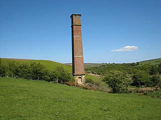
The Warren Moor Mine, was a short-lived mining concern south of Kildale, North Yorkshire, England. Activity at the site was limited to drift mining, and although shafts were sunk to mine the underground schemes, these ventures failed. The site of the workings have been stabilised, and the old chimney is the only Victorian ironstone mining chimney left in the United Kingdom.
The Ironstone mining in Rosedale, was a major mining concern, in Rosedale, North Yorkshire, England. It flourished in the 19th century and ceased in the early 20th, though smaller scale iron workings were in use through the Middle Ages. The ironstone from Rosedale was typically rated at a higher iron ore concentration in the rock than other mines in the Cleveland and North Yorkshire area.
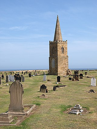
St Germain's Churchyard is a large cemetery overlooking the North Sea at Marske-by-the-Sea, North Yorkshire, England. Its church tower is a grade II listed structure at the midpoint to the yard and a landmark for sailors out on the sea. It is a remnant of a demolished church, services at St Germain's were replaced in 1876 by St Mark's.

Kilton Viaduct was a railway viaduct that straddled Kilton Beck, near to Loftus, in North Yorkshire, England. The viaduct was opened to traffic in 1867, however in 1911, with the viaduct suffering subsidence from the nearby ironstone mining, the whole structure was encased in waste material from the mines creating an embankment which re-opened fully to traffic in 1913. The railway closed in 1963, but then in 1974, it re-opened as part of the freight line to Boulby Mine carrying potash traffic.
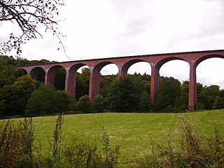
Saltburn Viaduct, is a railway bridge in Redcar and Cleveland, North Yorkshire, England. The line was built as an extension of the Redcar and Saltburn Railway, and the viaduct is mostly built out of brick. The line opened to passengers in 1872, but became freight only in 1957, a purpose for which it still is in use for today as part of the Boulby line.

Skelton Beck is a small river in North Yorkshire, England. The beck only runs for 23 kilometres (14 mi) and feeds directly into the North Sea on the south side of Saltburn beach. The beck is noted for occasionally being polluted with wastewater from the abandoned ironstone workings in its headwaters.
Slapewath is a hamlet in the borough of Redcar and Cleveland and the ceremonial county of North Yorkshire, England. Whilst the name of the hamlet is recorded as far back as the 13th century, it was developed due to the alum and ironstone industries of the North-Eastern part of Yorkshire in the 16th and 19th centuries respectively. The hamlet lies on the A171 road.

Hunt Cliff is a sea cliff or promontory, located between Saltburn and Skinningrove, in Redcar and Cleveland, on the Yorkshire Coast in England. Whilst Hunt Cliff is not as high as the nearby cliffs at Boulby, the view of it from Saltburn has been described as "very striking". Historically, the cliff has had many uses, being a signal station for the Romans, a place to mine ironstone, and a radar station during the Second World War. The Cleveland Way long-distance path traverses the cliff edge.

