
The Stikine River is a major river in northern British Columbia (BC), Canada and southeastern Alaska in the United States. It drains a large, remote upland area known as the Stikine Country east of the Coast Mountains. Flowing west and south for 610 kilometres (379 mi), it empties into various straits of the Inside Passage near Wrangell, Alaska. About 90 percent of the river's length and 95 percent of its drainage basin are in Canada. Considered one of the last truly wild large rivers in BC, the Stikine flows through a variety of landscapes including boreal forest, steep canyons and wide glacial valleys.

The Thompson River is the largest tributary of the Fraser River, flowing through the south-central portion of British Columbia, Canada. The Thompson River has two main branches, the South Thompson River and the North Thompson River. The river is home to several varieties of Pacific salmon and trout. The area's geological history was heavily influenced by glaciation, and the several large glacial lakes have filled the river valley over the last 12,000 years. Archaeological evidence shows human habitation in the watershed dating back at least 8,300 years. The Thompson was named by Fraser River explorer, Simon Fraser, in honour of his friend, Columbia Basin explorer David Thompson. Recreational use of the river includes whitewater rafting and angling.

The Amable du Fond River is a river in Nipissing District, in Northern Ontario, Canada.
The Brightsand River is a river in the James Bay drainage basin in Unorganized Thunder Bay District in northwestern Ontario, Canada.
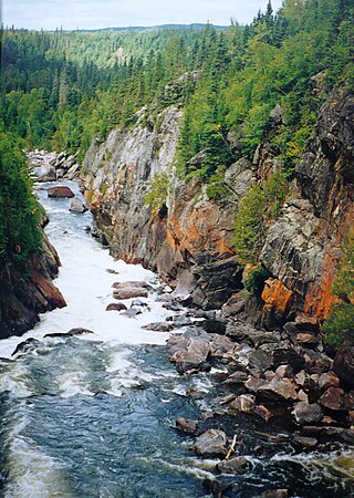
Telegraph Creek is a small community located off Highway 37 in northern British Columbia at the confluence of the Stikine River and Telegraph Creek. The only permanent settlement on the Stikine River, it is home to approximately 250 members of Tahltan First Nation and non-native residents. The town offers basic services, including Anglican and Catholic churches, a general store, a post office, a clinic with several nurses on-call around the clock, two Royal Canadian Mounted Police officers, and a K-9 school. Steep river banks and rocky gorges form the terraced nature of the geography.
The White River is a tributary of Lake Superior in Thunder Bay District, Ontario, Canada. It starts at Negwazu Lake and flows in a predominantly western direction to Lake Superior, passing through the Township of White River.

Juniper Beach Provincial Park is a provincial park in the Thompson Country region of south central British Columbia, Canada. The facility is on the north side of the Thompson River, west of the town of Savona, and downstream from the Kamloops Lake outflow. On BC Highway 1, the locality is by road about 20 kilometres (12 mi) east of Cache Creek and 65 kilometres (40 mi) west of Kamloops.
North Thompson Oxbows East Provincial Park is a provincial park in Thompson-Nicola Regional District in the Interior region of British Columbia, Canada. The park was established on April 30, 1996, and has an area of 288 hectares. The park protects a productive area of the North Thompson River lowlands that has high species diversity. There are patches of old-growth forest containing hybrid white spruce and subalpine fir. There are no camping or day-use facilities.
North Thompson Oxbows Jensen Island Provincial Park is a provincial park in Thompson-Nicola Regional District in the Interior region of British Columbia, Canada, about 20 kilometres (12 mi) north of Kamloops at the community of Heffley Creek. The park was established on April 30, 1996, and has an area of 30 hectares. It protects the riparian habitat of a single, seasonal oxbow on the right bank of the North Thompson River. There are no camping or day-use facilities.

The North Thompson River is the northern branch of the Thompson River, the largest tributary of the Fraser River, in the Canadian province of British Columbia. It originates at the toe of the Thompson Glacier in the Premier Range of the Cariboo Mountains, west of the community of Valemount. The river flows generally south through the Shuswap Highland towards Kamloops where it joins the South Thompson River to form the main stem Thompson River.

Loss Creek is a river in the Capital Regional District of British Columbia, Canada. Located on southern Vancouver Island, it flows through a long, steep-sided valley to the Strait of Juan de Fuca on the Pacific Ocean.
Skihist Mountain, also sometimes referred to as Skihist Peak, is the highest mountain in the Cantilever Range and in southwestern British Columbia, Canada. It is located on the southern boundary of Stein Valley Nlaka'pamux Heritage Park, about 20 km (12 mi) west of Lytton. It is the highest summit in the Lillooet Ranges, which lie between the Lillooet and Fraser Rivers, south of the Gates Valley and Seton and Anderson Lakes.

Nahta Cone is a small cinder cone in Cassiar Land District of northwestern British Columbia, Canada. It has an elevation of 1,670 metres and lies near the northern edge of the Arctic Lake Plateau, a glacially scored plateau of the Tahltan Highland which in turn extends along the western side of the Stikine Plateau. The cone is about 70 kilometres south-southeast of the community of Telegraph Creek and lies in the southwestern corner of Mount Edziza Provincial Park, one of the largest provincial parks in British Columbia.
Daisy Lake is a lake in the geographic townships of Butt and McCraney in the Unorganized South Part of Nipissing District, Ontario, Canada. The lake is in the Ottawa River drainage basin and is entirely within Algonquin Provincial Park.

The Groundhog River is a river in Cochrane District and Sudbury District in Northeastern Ontario, Canada. The river is in the James Bay drainage basin and is a left tributary of the Mattagami River.
The Little White River is a river in the Unorganized North Part of Algoma District in Northeastern Ontario, Canada. It is in the Great Lakes Basin and is a left tributary of the Mississagi River.
Moonbeam Creek is a stream in Thompson-Nicola Regional District in the Interior region of British Columbia, Canada. It is in the Pacific Ocean drainage basin and is a left tributary of the North Thompson River. The nearest communities to the mouth of the creek on British Columbia Highway 5 are Blue River 40 kilometres (25 mi) south and Valemount 50 kilometres (31 mi) north; the mouth of the creek is just downstream of confluence of the North Thompson River and the Albreda River, where the North Thompson River turns 90° right and heads south.
The Albreda River is a river in Thompson-Nicola Regional District and the Regional District of Fraser-Fort George in the Interior region of British Columbia, Canada. It is in the Pacific Ocean drainage basin and is a left tributary of the North Thompson River. The nearest communities to the mouth of the creek on British Columbia Highway 5 are Blue River 42 kilometres (26 mi) south and Valemount 48 kilometres (30 mi) north; the mouth of the river is at a point where the North Thompson River, arriving downstream from its source, turns 90° right and heads south.
Canvas Creek is a stream in Kamloops Division Yale Land District in the Interior region of British Columbia, Canada. It is in the Pacific Ocean drainage basin and is a right tributary of the North Thompson River.

Silver Lake is a lake in Tay Valley, Lanark County, and Central Frontenac, Frontenac County, in Eastern Ontario, Canada. It is the source of Silver Lake Creek and is in the Ottawa River drainage basin.

