Northampton Castle

Last updated

Northampton Castle
Northampton, England
Postern Gate of Northampton Castle 2013.jpg
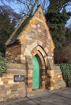
All that remains of Northampton Castle: a postern that was dismantled from its original position and rebuilt into the wall of Northampton railway station
Northamptonshire UK location map (2021).svg
Red pog.svg
Northampton Castle
Coordinates 52°14′13″N0°54′18″W / 52.237°N 0.905°W / 52.237; -0.905
Type Motte-and-bailey castle
Site information
ConditionDestroyed
Site history
Built1084
Built by Simon de Senlis

Northampton Castle in Northampton, was one of the most famous Norman castles in England. [1] The castle site was outside the western city gate, and defended on three sides by deep trenches. A branch of the River Nene provided a natural barrier on the western side. The castle had extensive grounds and a large keep. The gates were surrounded by bulwarks made of earth, used to mount artillery. The castle was "obliterated" by the arrival of a railway branch of what is now the West Coast Main Line in the 19th century, the station of which was built on the castle site and the construction of the original Northampton Castle railway station. All that remains of the castle today is the Postern Gate, near Northampton Railway Station.

Contents

History

Early period

The castle was built under the stewardship of Simon de Senlis, the first Earl of Northampton, in 1084. [2] It took several years to complete, as there is no mention of it in the Domesday Book, the great survey of England completed in 1086. In the reign of Henry II, the castle was in the hands of the Crown. In the First Barons' War between King John and his barons, the latter used it as a stronghold. When the King prevailed, the castle was entrusted to Falkes de Breauté, whom the King admired for his courage during the war. [3]

Map of Northampton by John Speed from 1610, showing the location of the castle at left (west) Map of Northampton, 1610, John Speed.jpg
Map of Northampton by John Speed from 1610, showing the location of the castle at left (west)

In 1164, Thomas Becket was tried at the castle before a great council. Having escaped by dressing as a monk, Becket then fled to France. [2]

In 1264, in the Second Barons' War between King Henry III and his nobles, the castle was owned by the confederate barons and governed by Simon de Montfort. When the King defeated the garrison at the Battle of Northampton in 1264, the castle again reverted to the Crown. It remained so until three years into King Edward III's reign, when Thomas Wake, who was then sheriff of Blisworth, claimed it belonged to the county under his jurisdiction. [4]

In 1452, thirty years into King Henry VI's reign, the castle was rented to Robert Caldecote for 20 years, at the annual rate of £5. The rent of the castle included:

... all the wifes belonging to the constableship of [the castle], and the herbage within the walls, and in the trenches, as also a certain meadow, and right of fishing in the river ... [5]

Later history

During the English Civil War the castle was used by the Parliamentarians. In 1662, in revenge for this, King Charles II ordered that the town walls and castle's defences be slighted (damaged and made useless as defences) so that they could not be used again as a fortification. From then on what remained of the castle was used as a court and a gaol, but its state of repair gradually worsened. Parts of the castle were still intact until the late 19th century, when the remains were sold to a railway company. [6] [7] By the late 17th century, it was in the hands of Robert Haselrig. [8]

Northampton Castle bastion from Historical Memorials of Northampton by C. H. Hartshorne Northampton Castle Bastion.jpg
Northampton Castle bastion from Historical Memorials of Northampton by C. H. Hartshorne
A postern at Northampton Castle from Hartshorne Northampton Castle Postern.jpg
A postern at Northampton Castle from Hartshorne

Victorian era

The development of railways in England during the Victorian period initially by-passed Northampton. The main line from London, Euston, now known as the West Coast Main Line passed about five miles south of the town. However, in 1879 a loop line via Northampton was constructed. In that year the castle and its foundations were demolished by the London and North Western Railway for the construction of Northampton Castle railway station. The only remains that survived were some earth banks beside St Andrew's Road and the re-positioned postern gate, "a minor archway". [1]

The station was rebuilt in 1963–64 [10] with the suffix "Castle" to its name dropped as it had become the only remaining station in the town. Excavations in 1961 prior to the rebuilding revealed 12th-century defences including a ditch 90 feet wide and 30 feet deep and a bank 80 feet wide and 20 feet high. [1]

21st century

A volunteer group called the Friends of Northampton Castle (FONC) was established to publicise the castle and provide information about the history of the site and the castle itself. In July 2012, FONC commissioned a 3D reconstruction of the castle which was published on YouTube. [11]

Expansion of the town and the 2011 launch of a Northampton Waterside Enterprise Zone made the need to expand and re-develop and double the size of the railway station, [12] possibly with the name restored to "Northampton Castle". Work began in 2013. The opportunity was taken to carry out further, more extensive, excavations in 2012–13 which uncovered various items of Anglo-Saxon origin. Among their number were a brooch, pottery fragments and an ironstone wall. [12]

Literary connections

Northampton Castle is the location of the death of Prince Arthur, the young nephew to King John and claimant to the throne, in Shakespeare's King John , Act IV Scene III, in which he leaps to his death from the castle walls in an escape attempt. [13]

The fate of the real-life Prince Arthur remains mysterious. He was last recorded as a sixteen-year-old captive in Rouen Castle in April 1203, whereafter he was rumoured to have been killed on King John's orders. It may be thought more likely that he died in France rather than England. [14]

Related Research Articles

<span class="mw-page-title-main">Northampton</span> Town in Northamptonshire, England

Northampton is a town and civil parish in Northamptonshire, England. It is the county town of Northamptonshire and the administrative centre of the unitary authority of West Northamptonshire. The town is situated on the River Nene, 60 miles (97 km) north-west of London and 50 miles (80 km) south-east of Birmingham. Northampton is one of the largest towns in England; the population of its urban area was recorded as 245,899 in the 2021 census.

<span class="mw-page-title-main">Hanslope</span> Civil parish in the City of Milton Keynes, England

Hanslope is a village and civil parish in the unitary authority area of the City of Milton Keynes, Buckinghamshire, England. The village is about 4 miles (6.4 km) west northwest of Newport Pagnell, about 4 miles (6.4 km) north of Stony Stratford and 8 miles (13 km) north of Central Milton Keynes. The northern parish boundary is part of the county boundary with Northamptonshire.

<span class="mw-page-title-main">William de Forz, 3rd Earl of Albemarle</span> 13th-century Anglo-Norman noble

William de Forz, 3rd Earl of Albemarle was an English nobleman. He is described by William Stubbs as "a feudal adventurer of the worst type".

<span class="mw-page-title-main">The Castle, Newcastle</span> 11th-century English castle

The Castle, Newcastle, or Newcastle Castle is a medieval fortification in Newcastle upon Tyne, England, built on the site of the fortress that gave the City of Newcastle its name. The most prominent remaining structures on the site are the Castle Keep, and the Black Gate, its fortified gatehouse.

<span class="mw-page-title-main">First Barons' War</span> Civil war in the Kingdom of England

The First Barons' War (1215–1217) was a civil war in the Kingdom of England in which a group of rebellious major landowners led by Robert Fitzwalter waged war against King John of England. The conflict resulted from King John's disastrous wars against King Philip II of France, which led to the collapse of the Angevin Empire, and John's subsequent refusal to accept and abide by the Magna Carta, which John had sealed on 15 June 1215.

<span class="mw-page-title-main">Carrickfergus Castle</span> Norman Castle on the island of Ireland

Carrickfergus Castle is a Norman castle in Northern Ireland, situated in the town of Carrickfergus in County Antrim, on the northern shore of Belfast Lough. Besieged in turn by the Scottish, native Irish, English, and French, the castle played an important military role until 1928 and remains one of the best preserved medieval structures in Northern Ireland. It was strategically useful, with 3/4 of the castle perimeter surrounded by water. Today it is maintained by the Department for Communities as a state care historic monument, at grid ref: J4143 8725.

<span class="mw-page-title-main">Oxford Castle</span> Partly ruined castle in Oxford in Oxfordshire, England

Oxford Castle is a large, partly ruined medieval castle on the western side of central Oxford in Oxfordshire, England. Most of the original moated, wooden motte and bailey castle was replaced in stone in the late 12th or early 13th century and the castle played an important role in the conflict of the Anarchy. In the 14th century the military value of the castle diminished and the site became used primarily for county administration and as a prison. The surviving rectangular St George's Tower is now believed to pre-date the remainder of the castle and be a watch tower associated with the original Saxon west gate of the city.

A postern is a secondary door or gate in a fortification such as a city wall or castle curtain wall. Posterns were often located in a concealed location which allowed the occupants to come and go inconspicuously. In the event of a siege, a postern could act as a sally port, allowing defenders to make a sortie on the besiegers. Placed in a less exposed, less visible location, they were usually relatively small, and therefore easily defensible.

<span class="mw-page-title-main">Northampton railway station</span> Railway station in Northamptonshire, England

Northampton railway station serves the county town of Northampton in England. It is on the Northampton Loop of the West Coast Main Line and is located 65 miles 68 chains from London Euston. The station is served by West Midlands Trains services between London Euston and Birmingham New Street; there is also a limited direct service to Crewe. A handful of Avanti West Coast services also serve the station, but these have been greatly reduced due to the longer-term impact of the COVID-19 pandemic in the United Kingdom.

<span class="mw-page-title-main">York city walls</span> Grade I listed urban defence in England

York has, since Roman times, been defended by walls of one form or another. To this day, substantial portions of the walls remain, and York has more miles of intact wall than any other city in England. They are known variously as York City Walls, the Bar Walls and the Roman walls. The walls are generally 13 feet (4m) high and 6 feet (1.8m) wide. They are the longest town walls in England.

<span class="mw-page-title-main">Falkes de Bréauté</span> Anglo-Norman soldier (died 1226)

Sir Falkes de Bréauté was an Anglo-Norman soldier who earned high office by loyally serving first King John and later King Henry III in the First Barons' War. He played a key role in the Battle of Lincoln Fair in 1217. He attempted to rival Hubert de Burgh, and as a result fell from power in 1224. His "heraldic device" is now popularly said to have been a griffin, although his coat of arms as depicted by Matthew Paris in his Chronica Majora was Gules, a cinquefoil argent.

<span class="mw-page-title-main">Blisworth</span> Human settlement in England

Blisworth is a village and civil parish in the West Northamptonshire, England. The West Coast Main Line, from London Euston to Manchester and Scotland, runs alongside the village partly hidden and partly on an embankment. The Grand Union Canal passes through the village and the north portal of the Blisworth tunnel is near Stoke Road.

<span class="mw-page-title-main">Battle of Lincoln (1217)</span> Battle during the First Barons War

The Second Battle of Lincoln occurred at Lincoln Castle on Saturday 20 May 1217, during the First Barons' War, between the forces of the future Louis VIII of France and those of King Henry III of England. Louis's forces were attacked by a relief force under the command of William Marshal, 1st Earl of Pembroke. Thomas, Count of Perche, commanding the French troops, was killed and Louis was expelled from his base in the southeast of England. The looting that took place afterwards is known as the "Lincoln Fair". The citizens of Lincoln were loyal to Louis so Henry's forces sacked the city.

<span class="mw-page-title-main">Battle of Northampton (1264)</span> Battle in the Second Barons War

The Battle of Northampton was a battle in the Second Barons' War. A decisive victory for the royalist forces of King Henry III of England, who took Northampton Castle and captured Simon de Montfort, son of Simon de Montfort.

<span class="mw-page-title-main">Bedford Castle</span> Medieval castle in Bedford, England

Bedford Castle was a large medieval castle in Bedford, England. Built after 1100 by Henry I, the castle played a prominent part in both the civil war of the Anarchy and the First Barons' War. The castle was significantly extended in stone, although the final plan of the castle remains uncertain. Henry III of England besieged the castle in 1224 following a disagreement with Falkes de Breauté; the siege lasted eight weeks and involved an army of as many as 2,700 soldiers with equipment drawn from across England. After the surrender of the castle, the king ordered its destruction (slighting).

<span class="mw-page-title-main">Gayton, Northamptonshire</span> Human settlement in England

Gayton is a rural village and civil parish in West Northamptonshire, England, 5 miles (8 km) south-west of Northampton town centre. The village is situated on a hill close to the larger villages of Bugbrooke, Milton Malsor and Blisworth, with a linked public footpath network. At the 2011 Census, the population of the parish was 544.

Ely Castle was in the cathedral city of Ely in Cambridgeshire. Its probable site is a mound near the cathedral which is now called Cherry Hill.

<span class="mw-page-title-main">Rochester Castle</span> Well preserved 12th century castle in Rochester, Kent, South East England

Rochester Castle stands on the east bank of the River Medway in Rochester, Kent, South East England. The 12th-century keep or stone tower, which is the castle's most prominent feature, is one of the best preserved in England or France.

<span class="mw-page-title-main">Easton Neston</span> Human settlement in England

Easton Neston is situated in south Northamptonshire, England. Though the village of Easton Neston which was inhabited until around 1500 is now gone, the parish retains the name. At the 2011 Census the population of the civil parish remained less than 100 and was included in the town of Towcester.

<span class="mw-page-title-main">Blisworth Arch</span> Bridge in Northamptonshire, England

The Blisworth Arch or is a railway bridge in Blisworth, Northamptonshire, in eastern England. It was designed by Robert Stephenson for the London and Birmingham Railway and completed in 1837. It is a grade II listed building and a significant local landmark.

References

  1. 1 2 3 Pevsner, Nikolaus; Cherry, Bridget (revision) (1961). The Buildings of England – Northamptonshire. London and New Haven: Yale University Press. p. 328. ISBN   978-0-300-09632-3.
  2. 1 2 "A Castle For Northampton". Friends of Northampton Castle. Retrieved 19 September 2019.
  3. Beesley, Alfred (1841). The History of Banbury: including copious historical and antiquarian notices of the neighbourhood. Nichols & Son. p.  101. Falkes de Breauté Northampton Castle.
  4. "The Wakes of Blisworth". Wake History. Retrieved 19 September 2019.
  5. The history of the town of Northampton, 1841
  6. "The Development of Northampton". British History Online. Retrieved 11 April 2023.
  7. "Discover Northampton's own 'lost' castle". www.northamptonchron.co.uk. 18 July 2011. Archived from the original on 3 June 2015.
  8. The decline of Northampton Castle. Friends of Northampton Castle. Retrieved 19 September 2019.
  9. Historical Memorials of Northampton Charles Henry Hartshorne, 1848 Reprinted: General books 2012 ISBN   1235776204 ISBN   978-1235776205
  10. Pevsner, Nikolaus; Cherry, Bridget (revision) (1961). The Buildings of England – Northamptonshire. London and New Haven: Yale University Press. p. 327. ISBN   978-0-300-09632-3.
  11. "Northampton Castle 3D Reconstruction". Friends of Northampton Castle. 6 July 2012. Archived from the original on 21 December 2021. Retrieved 24 July 2012.
  12. 1 2 Historical finds at site of new station Northampton Herald & Post 10 January 2012
  13. Peter Whitfield (5 February 2016). Mapping Shakespeare's World. Bodleian Library. p. 145. ISBN   978-1-85124-257-3.
  14. "Arthur of Brittany Captured". History Today. 1 August 2002. Retrieved 19 September 2019.

Further reading