Northland Pyrite Mine

Last updated
Northland Pyrite Mine

Northland shaft.jpg

The loading dock at the southern end of the Northland Pyrite Mine site
Location
Canada Ontario location map 2.svg
Schlaegel und Eisen nach DIN 21800.svg
Northland Pyrite Mine
Location in Ontario
Location Temagami
Province Ontario
Country Canada
Coordinates 47°17′N80°02′W / 47.29°N 80.03°W / 47.29; -80.03 Coordinates: 47°17′N80°02′W / 47.29°N 80.03°W / 47.29; -80.03
Production
Products Chalcopyrite, pyrite, pyrrhotite
Production 76,067,050 pounds
History
Opened 1906
Closed 1911
Owner
Company Boland Lake Resources

The Northland Pyrite Mine, also known as James Lake Mine, Rib Lake Mine, Harris Mine or simply Northland Mine, is an abandoned underground mine in Northeastern Ontario, Canada, located on the southwestern shore of James Lake in Best Township of Temagami. It was operated by the Northland Mining Company during the early 1900s with the construction of a 91 m (299 ft) shaft and many open-cuts north of the shaft. Minerals present at the mine include chalcopyrite, pyrite and pyrrhotite, deposited in Precambrian volcanic rock of the Canadian Shield.

Underground mining (hard rock) underground mining techniques used to excavate hard minerals

Underground hard rock mining refers to various underground mining techniques used to excavate hard minerals, usually those containing metals such as ore containing gold, silver, iron, copper, zinc, nickel, tin and lead, but also involves using the same techniques for excavating ores of gems such as diamonds or rubies. Soft rock mining refers to excavation of softer minerals such as salt, coal, or oil sands.

Northeastern Ontario Secondary region in Ontario, Canada

Northeastern Ontario is a secondary region of Northern Ontario which lies north of Lake Huron and east of Lake Superior.

Canada Country in North America

Canada is a country in the northern part of North America. Its ten provinces and three territories extend from the Atlantic to the Pacific and northward into the Arctic Ocean, covering 9.98 million square kilometres, making it the world's second-largest country by total area. Canada's southern border with the United States, stretching some 8,891 kilometres (5,525 mi), is the world's longest bi-national land border. Its capital is Ottawa, and its three largest metropolitan areas are Toronto, Montreal, and Vancouver. As a whole, Canada is sparsely populated, the majority of its land area being dominated by forest and tundra. Consequently, its population is highly urbanized, with over 80 percent of its inhabitants concentrated in large and medium-sized cities, with 70% of citizens residing within 100 kilometres (62 mi) of the southern border. Canada's climate varies widely across its vast area, ranging from arctic weather in the north, to hot summers in the southern regions, with four distinct seasons.

Contents

History

Before the operation of Northland Pyrite Mine in the early 1900s, water levels of James Lake increased and decreased. [1] The cause of this alternation could have been caused by beavers building dams in the lake's outlet, eventually causing the water levels to rise. [1] This rise in water levels began to cease in 1906 when operations of the Northland Pyrite Mine began to dump volcanic waste rock along the southwestern shore of James Lake. [1] This began with the construction of the 91 m (299 ft) shaft and the several open-cuts north of the shaft, but the mine site was originally discovered in 1903. [2] Erosion of the volcanic waste rock resulted in the development of acidic lake wastewaters next to the waste pile, causing organisms around the mine to disappear. [1] The name Harris Mine was coined for Northland Pyrite Mine by E.L. Fraleck in 1907 when Northland was actively operating for a year. [2]

Beaver genus of mammals

The beaver is a large, primarily nocturnal, semiaquatic rodent. Castor includes two extant species, the North American beaver and Eurasian beaver (Eurasia). Beavers are known for building dams, canals, and lodges (homes). They are the second-largest rodent in the world. Their colonies create one or more dams to provide still, deep water to protect against predators, and to float food and building material. The North American beaver population was once more than 60 million, but as of 1988 was 6–12 million. This population decline is the result of extensive hunting for fur, for glands used as medicine and perfume, and because the beavers' harvesting of trees and flooding of waterways may interfere with other land uses.

From February 1906 to March 1911, the Northland Pyrite Mine was in nearly continuous production. According to a former report from the Ontario Northland Railway, 76,067,050 pounds were sent throughout this epoch and was shipped to the town of Cobalt further north. [2] A.A. Cole, who was the former manager of the former Temiskaming Testing Laboratories facility in Cobalt, stated the closure of Northland was due to the mine transporting pyrrhotite instead of pyrite for three days. [2] The mined pyrrhotite was said to be in a parallel lens to the mined pyrite and its quality was unnoticed. [2] During mine closer in March 1911, the 91 m (299 ft) shaft was filled in with logs and waste rock and the adjacent waters of James Lake has since flooded the mine to create more acidic lake wastewater. Colours of the wastewater range from orange to dark red in the central portion of the mine site and green in a narrow open-cut at the southern end of the mine site just west of the mine shaft.

Ontario Northland Railway

The Ontario Northland Railway is a Canadian railway operated by the Ontario Northland Transportation Commission, a provincial Crown agency of the government of Ontario.

Cobalt, Ontario Town in Ontario, Canada

Cobalt is a town in the district of Timiskaming, in the province of Ontario, Canada, with a population of 1,118 according to the Canada 2016 Census.

Pyrrhotite sulfide mineral; polytypes: 11H, 3T, 4C, 4H, 4M, 5C, 6C, 6M, 7H

Pyrrhotite is an iron sulfide mineral with the formula Fe(1-x)S. It is a nonstoichiometric variant of FeS, the mineral known as troilite. Pyrrhotite is also called magnetic pyrite, because the color is similar to pyrite and it is weakly magnetic. The magnetism decreases as the iron content increases, and troilite is non-magnetic.

Geology

The Northland Pyrite Mine lies in a pyrite-bearing zone associated with a band of Keewatin bedded tuffs. [2] This is the only major pyrite zone in the James Lake area and the Northland Pyrite Mine is the only past producer in the area, with no operating mines present. [2] Cobalt-silver, molybdenum, platinum, nickel, gold and copper exist in the zone. [2]

Tuff Rock consolidated from volcanic ash

Tuff, also known as volcanic tuff, is a type of rock made of volcanic ash ejected from a vent during a volcanic eruption. Following ejection and deposition, the ash is compacted into a solid rock in a process called consolidation. Tuff is sometimes erroneously called "tufa", particularly when used as construction material, but properly speaking, tufa is a limestone precipitated from groundwater. Rock that contains greater than 50% tuff is considered tuffaceous.

Silver Chemical element with atomic number 47

Silver is a chemical element with symbol Ag and atomic number 47. A soft, white, lustrous transition metal, it exhibits the highest electrical conductivity, thermal conductivity, and reflectivity of any metal. The metal is found in the Earth's crust in the pure, free elemental form, as an alloy with gold and other metals, and in minerals such as argentite and chlorargyrite. Most silver is produced as a byproduct of copper, gold, lead, and zinc refining.

Molybdenum Chemical element with atomic number 42

Molybdenum is a chemical element with symbol Mo and atomic number 42. The name is from Neo-Latin molybdaenum, from Ancient Greek Μόλυβδος molybdos, meaning lead, since its ores were confused with lead ores. Molybdenum minerals have been known throughout history, but the element was discovered in 1778 by Carl Wilhelm Scheele. The metal was first isolated in 1781 by Peter Jacob Hjelm.

See also

Related Research Articles

Lake Temagami lake in Temagami, Ontario, Canada

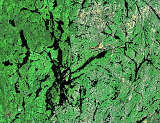
Lake Temagami, formerly spelled as Lake Timagami, is a lake in Nipissing District in northeastern Ontario, Canada, situated approximately 80 km north of North Bay. The lake's name comes from Te-mee-ay-gaming, which means "deep water by the shore" in the Ojibwa language.

Temagami Municipality in Ontario, Canada

Temagami, formerly spelled as Timagami, is a municipality in northeastern Ontario, Canada, in the Nipissing District with Lake Temagami at its heart.

Copperfields Mine abandoned mine on Temagami island, Temagani lake

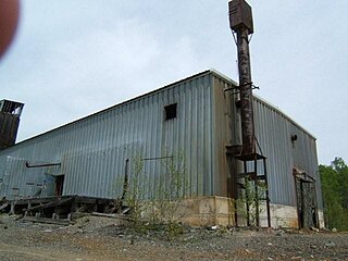
Copperfields Mine, originally known as Temagami Mine, is an abandoned copper and silver mine on Temagami Island in Lake Temagami, Ontario, Canada. The mine opened in 1955 and comprises both underground and surface workings within a sulfide ore body. Situated in Phyllis Township, the mine produced 34,000,000 dollars Canadian with 80 million pounds of copper, 230,028 ounces of silver and 13,271 ounces of gold. It was considered to be the largest deposit of nearly pure chalcopyrite ever discovered in Canada. A mill was not initially needed because the ore was 28% copper. The mine closed in 1972 and is now flooded by water. Ruins of the Copperfields mill are present as foundations. It is possible to find mineral specimens in the spoil heaps of the old mine, such as chalcopyrite, pyrite, bornite, malachite, dolomite, hessite, merenskyite, millerite, palladium, quartz and others. The Lake Temagami Access Road was created to ship ore from the mine site.

Kanichee Mine

The Kanichee Mine, also less commonly known as the Ajax Mine, is an abandoned base metal and precious metal mine, located in the Temagami region of northeastern Ontario, Canada. It is near the small unincorporated community of Temagami North, accessed by the Kanichee Mine Road from Highway 11. The Kanichee Mine zone has been explored and mined discontinuously from as early as 1910. During the 20th century, it operated and closed down at least three times, with the most recent being from 1973 to 1976. To date, the discontinuous operation of Kanichee Mine has produced 4.2 million pounds of metal.

Temagami Greenstone Belt

The Temagami Greenstone Belt (TGB) is a small 2.7 billion year old greenstone belt in the Temagami region of Northeastern Ontario, Canada. It represents a feature of the Superior craton, an ancient and stable part of the Earth's lithosphere that forms the core of the North American continent and Canadian Shield. The belt is composed of metamorphosed volcanic rocks that range in composition from basalt to rhyolite. These form the east-northeast trend of the belt and are overlain by metamorphosed sedimentary rocks. They were created during several volcanic episodes involving a variety of eruptive styles ranging from passive lava eruptions to viscous explosive eruptions.

Beanland Mine

Beanland Mine, also known as Clenor Mine, is an abandoned surface and underground mine in Northeastern Ontario, Canada. It is located about 1 km (0.62 mi) west of Arsenic Lake and 4 km (2.5 mi) northwest of the town of Temagami in central Strathy Township. It is named after Sydney Beanland, who first claimed the mine site in the 1920s and was a director for the mine from 1937 to 1938.

James Lake (Ontario) lake in Ontario, Canada

James Lake is a lake in northeastern Ontario, Canada, located in the Temagami region along Highway 11.

Barton Mine

Barton Mine, also known as Net Lake Mine, is an abandoned surface and underground mine in Northeastern Ontario, Canada. It is located about 0.50 km (0.31 mi) north of the Temagami Arena in Temagami North and just east of the Ontario Northland Railway in northwestern Strathy Township. Dating back to the early 1900s, it is one of the oldest mines in Temagami. Barton was the site of a fire in the early 1900s, after which it never had active mining again.

Big Dan Mine

Big Dan Mine is an abandoned underground mine in Northeastern Ontario, Canada. It is located about 1 km (0.62 mi) southwest of Net Lake and just west of the Ontario Northland Railway in east-central Strathy Township. It is named after Dan O'Connor, who first claimed the site in the 1890s.

Best Township, Ontario Geographic township in Ontario, Canada

Best Township is a geographic township comprising a portion of the municipality of Temagami in Nipissing District, Northeastern Ontario, Canada. It is used for geographic purposes, such as land surveying and natural resource explorations. Neighbouring geographic townships include Gillies Limited Township to the north, Banting Township to the west, Chambers Township to the southwest, and Strathy and Cassels townships to the south.

Hermiston-McCauley Mine

Hermiston-McCauley Mine is a large abandoned underground gold mine in Strathy Township of Temagami, Northeastern Ontario, Canada. It is located between the southwestern arm of Net Lake and the south arm of Kanichee Lake.

Mopani Copper Mines PLC ("Mopani") is a Zambian registered company owned by Carlisa Investments Corporation and ZCCM-IH (10%). Minority shareholders are spread throughout the world, in various locations.

Johnny Creek

Johnny Creek is one of many creeks running through the Temagami region of Northeastern Ontario, Canada. It is located about 4 km (2.5 mi) south of Temagami North in southeastern Strathy Township. The creek is entirely within the municipality of Temagami, flowing in a west–east direction.

Temagami-Lorrain Mine

Temagami-Lorrain Mine is an abandoned surface and underground mine in Northeastern Ontario, Canada. It is located about 10 km (6.2 mi) northeast of the town of Temagami near Sauvé Lake in central Cassels Township. It is named after the Temagami-Lorrain Mining Company, which carried out work on the property in the early 1900s.

Priest Mine abandoned mine in northeastern Ontario, Canada

Priest Mine is an abandoned surface and underground mine in Northeastern Ontario, Canada. It is located about 19 km (12 mi) northwest of the hamlet of Marten River on an island in north-central Cross Lake. Dating back to the early 1900s, it is one of the oldest mines in the municipality of Temagami.

Danlou Occurrence

The Danlou Occurrence, also known as the Danlou Gold Occurrence and the Mortimer Occurrence, is a mineralized zone in Northeastern Ontario, Canada. It is located 10 km (6.2 mi) north-northeast of the town of Temagami between Highway 11 and the Ontario Northland Railway. It is named after Danlou Mines Limited, which did work on the Danlou Occurrence in the early 1960s.

Northeast Arm Iron Range

The Northeast Arm Iron Range, also called the Temagami Iron Range, is an elongated area of iron ore in Nipissing District of Northeastern Ontario, Canada. It parallels the western side of Lake Temagami's Northeast Arm near the village of Temagami at its northern end. One of many small iron ranges in the Temagami area, the Northeast Arm Range consists of alternating bands of iron-rich and iron-poor sediments. It was discovered in the 1890s and has since seen sporadic mining and mineral exploration activities.

References

The Abandoned Mines Information System (AMIS) is a database created by the Ministry of Northern Development and Mines of Ontario, Canada. It includes over 5,600 abandoned and inactive mines throughout Ontario, as well as associated hazards. Basic information about every known abandoned and inactive mine in Ontario is in the database, including name, location and period when it was in operation.

Ministry of Northern Development and Mines Ministry of the Government of Ontario

The Ministry of Northern Development and Mines (MNDM) is responsible for assisting economic development in the Northern Ontario region and for mining in the Canadian province of Ontario.