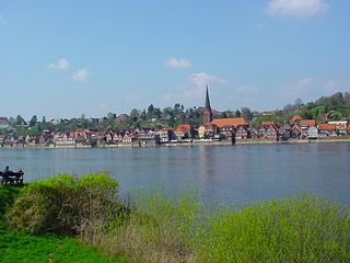
Lauenburg, or Lauenburg an der Elbe, is a town in the state of Schleswig-Holstein, Germany. It is situated on the northern bank of the river Elbe, east of Hamburg. It is the southernmost town of Schleswig-Holstein and belongs to the Kreis (district) of Herzogtum Lauenburg.
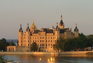
Schwerin is the capital and second-largest city of the northeastern German state of Mecklenburg-Vorpommern as well as of the region of Mecklenburg, after Rostock. It has around 96,000 inhabitants, and is thus the least populous of all German state capitals.
Oebisfelde is a town and a former municipality in the Börde district in Saxony-Anhalt, Germany. Since 1 January 2010, it is part of the town Oebisfelde-Weferlingen. It is accessed by Bundesstraße 188.

Heiligensee is a locality within Reinickendorf, a borough of the German capital, Berlin. It has 17,780 inhabitants and an area of 10.7 km2 (4.1 sq mi).
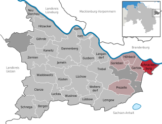
Schnackenburg is a town in the Lüchow-Dannenberg district, in Lower Saxony, Germany. It is situated on the left bank of the Elbe. It is part of the Samtgemeinde Gartow. Lying at the easternmost projection of Lower Saxony, the town is bordered on all sides except the west by territory that was formerly East Germany. It is the least densely populated town ("Stadt") in what was West Germany, although there are nine towns in what was formerly East Germany that are less densely populated.

Büchen is a municipality in the district of Lauenburg, in Schleswig-Holstein, Germany. It is seat of the Amt Büchen.

Jarmen is a town in the Vorpommern-Greifswald district, in Mecklenburg-Western Pomerania, Germany. It is situated on the southern bank of the river Peene, 20 km south of Greifswald, in the historic region of Pomerania.
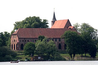
Zarrentin am Schaalsee, until 2004 simply Zarrentin, is a town in the Ludwigslust-Parchim district, in Mecklenburg-Western Pomerania, Germany. It is situated on the Schaalsee lake, 19 km southeast of Ratzeburg, and 34 km west of Schwerin.

Töpen is a municipality in Upper Franconia in the district of Hof in Bavaria in Germany.
Dallgow-Döberitz is a municipality in the Havelland district, in Brandenburg, Germany.

Cumlosen is a municipality in the Prignitz district, in Brandenburg, Germany.

Garz is a small municipality on the island of Usedom in the Vorpommern-Greifswald landkreis in the state of Mecklenburg-Vorpommern, Germany.

Rühen is a municipality in the district of Gifhorn, in Lower Saxony, Germany. The Municipality Rühen includes the villages of Brechtorf, Eischott and Rühen.

Gerstungen is a municipality in the Wartburgkreis district of Thuringia, Germany. In July 2018 the former municipalities of Marksuhl and Wolfsburg-Unkeroda were merged into Gerstungen.
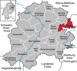
Wildeck is a community in Hersfeld-Rotenburg district in northeastern Hesse, Germany lying right at the boundary with Thuringia, 54 km southeast of Kassel.

Schwanheide is a municipality in the Ludwigslust-Parchim district, in Mecklenburg-Vorpommern, Germany.

Bargischow is a municipality in the Vorpommern-Greifswald district, in Mecklenburg-Vorpommern, Germany.

Gudow is a municipality in the district of Lauenburg, in Schleswig-Holstein, Germany.

Probstzella is a municipality in the district Saalfeld-Rudolstadt, in Thuringia, Germany.

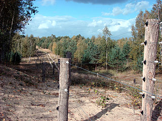
The State of Mecklenburg was a subdivision of the Soviet occupation zone and one of the states of East Germany which corresponds widely to the present-day German state Mecklenburg-Vorpommern. The state was originally formed as an administrative division, the State of Mecklenburg-Vorpommern, by the Soviet Military Administration in Germany (SMAD) in July 1945. It consisted of the 1934-established Mecklenburg and parts of the former Prussian provinces of Pommern and Hanover. The city of Swinemünde was handed over to Poland in October 1945, becoming part of Szczecin Voivodeship. In November 1945, a transfer of small territories along the Inner German border to the former Province of Schleswig-Holstein was carried out as part of the Barber–Lyashchenko Agreement. About 2.1 million people were estimated to live in Mecklenburg in 1946. From 1947, the term Vorpommern was excluded from the official name as the SMAD feared that this would support revisionist actions against formerly German parts of Poland. Compared to the administrative divisions of Nazi Germany, Mecklenburg comprised the Gaue Mecklenburg and parts of Pomerania and Eastern Hanover.


