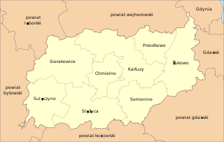
Borowo ; Kashubian: Bòrowò is a village in the administrative district of Gmina Kartuzy, within Kartuzy County, Pomeranian Voivodeship, in northern Poland. It lies approximately 6 kilometres (4 mi) east of Kartuzy and 24 km (15 mi) west of the regional capital Gdańsk.
Kaliska is a village in the administrative district of Gmina Kartuzy, within Kartuzy County, Pomeranian Voivodeship, in northern Poland. It lies approximately 3 kilometres (2 mi) east of Kartuzy and 27 km (17 mi) west of the regional capital Gdańsk.
Kamionka Brodnicka is a village in the administrative district of Gmina Kartuzy, within Kartuzy County, Pomeranian Voivodeship, in northern Poland. It lies approximately 12 kilometres (7 mi) south-west of Kartuzy and 38 km (24 mi) west of the regional capital Gdańsk.
Mezowo is a village in the administrative district of Gmina Kartuzy, within Kartuzy County, Pomeranian Voivodeship, in northern Poland. It lies approximately 5 kilometres (3 mi) south-east of Kartuzy and 27 km (17 mi) west of the regional capital Gdańsk.
Nowiny is a village in the administrative district of Gmina Kartuzy, within Kartuzy County, Pomeranian Voivodeship, in northern Poland. It lies approximately 6 kilometres (4 mi) north-west of Kartuzy and 32 km (20 mi) west of the regional capital Gdańsk.
Pikarnia is a village in the administrative district of Gmina Kartuzy, within Kartuzy County, Pomeranian Voivodeship, in northern Poland. It lies approximately 6 kilometres (4 mi) south-east of Kartuzy and 24 km (15 mi) west of the regional capital Gdańsk.
Smętowo Leśne is a village in the administrative district of Gmina Kartuzy, within Kartuzy County, Pomeranian Voivodeship, in northern Poland. It lies approximately 6 kilometres (4 mi) south-west of Kartuzy and 33 km (21 mi) west of the regional capital Gdańsk.
Sytna Góra is a village in the administrative district of Gmina Kartuzy, within Kartuzy County, Pomeranian Voivodeship, in northern Poland. It lies approximately 6 kilometres (4 mi) north of Kartuzy and 30 km (19 mi) west of the regional capital Gdańsk.
Szotowo is a village in the administrative district of Gmina Kartuzy, within Kartuzy County, Pomeranian Voivodeship, in northern Poland. It lies approximately 5 kilometres (3 mi) south-west of Kartuzy and 33 km (21 mi) west of the regional capital Gdańsk.
Pomieczyno is a village in the administrative district of Gmina Przodkowo, within Kartuzy County, Pomeranian Voivodeship, in northern Poland. It lies approximately 7 kilometres (4 mi) north-west of Przodkowo, 10 km (6 mi) north of Kartuzy, and 29 km (18 mi) west of the regional capital Gdańsk.
Szarłata is a village in the administrative district of Gmina Przodkowo, within Kartuzy County, Pomeranian Voivodeship, in northern Poland. It lies approximately 4 kilometres (2 mi) west of Przodkowo, 6 km (4 mi) north of Kartuzy, and 27 km (17 mi) west of the regional capital Gdańsk.

Kujaty is a Kashubian village in the administrative district of Gmina Sierakowice, within Kartuzy County, Pomeranian Voivodeship, in northern Poland. It lies approximately 5 kilometres (3 mi) south of Sierakowice, 21 km (13 mi) west of Kartuzy, and 50 km (31 mi) west of the regional capital Gdańsk.
Łączki is a village in the administrative district of Gmina Sierakowice, within Kartuzy County, Pomeranian Voivodeship, in northern Poland. It lies approximately 7 kilometres (4 mi) east of Sierakowice, 14 km (9 mi) west of Kartuzy, and 42 km (26 mi) west of the regional capital Gdańsk.
Łyśniewo Sierakowickie is a village in the administrative district of Gmina Sierakowice, within Kartuzy County, Pomeranian Voivodeship, in northern Poland. It lies approximately 4 kilometres (2 mi) west of Sierakowice, 24 km (15 mi) west of Kartuzy, and 52 km (32 mi) west of the regional capital Gdańsk.
Stara Huta is a village in the administrative district of Gmina Sierakowice, within Kartuzy County, Pomeranian Voivodeship, in northern Poland. It lies approximately 12 kilometres (7 mi) west of Sierakowice, 32 km (20 mi) west of Kartuzy, and 60 km (37 mi) west of the regional capital Gdańsk.
Ostowo is a settlement in the administrative district of Gmina Somonino, within Kartuzy County, Pomeranian Voivodeship, in northern Poland. It lies approximately 7 kilometres (4 mi) west of Somonino, 10 km (6 mi) south-west of Kartuzy, and 36 km (22 mi) west of the regional capital Gdańsk.
Krzeszna is a village in the administrative district of Gmina Stężyca, within Kartuzy County, Pomeranian Voivodeship, in northern Poland. It lies approximately 10 kilometres (6 mi) east of Stężyca, 14 km (9 mi) south-west of Kartuzy, and 39 km (24 mi) south-west of the regional capital Gdańsk.
Pierszczewo is a village in the administrative district of Gmina Stężyca, within Kartuzy County, Pomeranian Voivodeship, in northern Poland. It lies approximately 7 kilometres (4 mi) east of Stężyca, 16 km (10 mi) south-west of Kartuzy, and 42 km (26 mi) west of the regional capital Gdańsk.
Smokowo is a village in the administrative district of Gmina Stężyca, within Kartuzy County, Pomeranian Voivodeship, in northern Poland. It lies approximately 5 kilometres (3 mi) north-east of Stężyca, 17 km (11 mi) south-west of Kartuzy, and 44 km (27 mi) west of the regional capital Gdańsk.
Smażyno is a village in the administrative district of Gmina Linia, within Wejherowo County, Pomeranian Voivodeship, in northern Poland.