Sucha Huta is a village in the administrative district of Gmina Przywidz, within Gdańsk County, Pomeranian Voivodeship, in northern Poland. It lies approximately 6 kilometres (4 mi) south of Przywidz, 23 km (14 mi) south-west of Pruszcz Gdański, and 31 km (19 mi) south-west of the regional capital Gdańsk.
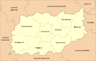
Bór-Okola is a village in the administrative district of Gmina Kartuzy, within Kartuzy County, Pomeranian Voivodeship, in northern Poland. It lies approximately 6 kilometres (4 mi) south-east of Kartuzy and 26 km (16 mi) west of the regional capital Gdańsk.
Brodnica Dolna , , is a village in the administrative district of Gmina Kartuzy, within Kartuzy County, Pomeranian Voivodeship, in northern Poland. It lies approximately 11 kilometres (7 mi) south-west of Kartuzy and 37 km (23 mi) west of the regional capital Gdańsk.
Prokowskie Chrósty is a village in the administrative district of Gmina Kartuzy, within Kartuzy County, Pomeranian Voivodeship, in northern Poland. It lies approximately 3 kilometres (2 mi) north of Kartuzy and 29 km (18 mi) west of the regional capital Gdańsk.
Grodzisko is a settlement in the administrative district of Gmina Chmielno, within Kartuzy County, Pomeranian Voivodeship, in northern Poland. It lies approximately 7 kilometres (4 mi) west of Chmielno, 14 km (9 mi) west of Kartuzy, and 42 km (26 mi) west of the regional capital Gdańsk.
Przodkowo is a village in Kartuzy County, Pomeranian Voivodeship, in northern Poland. It is the seat of the gmina called Gmina Przodkowo. It lies approximately 8 kilometres (5 mi) north-east of Kartuzy and 23 km (14 mi) west of the regional capital Gdańsk.
Przodkowo Działki is a village in the administrative district of Gmina Przodkowo, within Kartuzy County, Pomeranian Voivodeship, in northern Poland. It lies approximately 1 kilometre (1 mi) east of Przodkowo, 9 km (6 mi) north-east of Kartuzy, and 22 km (14 mi) west of the regional capital Gdańsk.
Sośniak is a settlement in the administrative district of Gmina Przodkowo, within Kartuzy County, Pomeranian Voivodeship, in northern Poland. It lies approximately 4 kilometres (2 mi) south-west of Przodkowo, 5 km (3 mi) north-east of Kartuzy, and 26 km (16 mi) west of the regional capital Gdańsk.
Gowidlino is a Kashubian village in the administrative district of Gmina Sierakowice, within Kartuzy County, Pomeranian Voivodeship, in northern Poland. It lies approximately 7 kilometres (4 mi) west of Sierakowice, 27 km (17 mi) west of Kartuzy, and 55 km (34 mi) west of the regional capital Gdańsk.
Karczewko is a village in the administrative district of Gmina Sierakowice, within Kartuzy County, Pomeranian Voivodeship, in northern Poland. It lies approximately 3 kilometres (2 mi) north-west of Sierakowice, 23 km (14 mi) west of Kartuzy, and 50 km (31 mi) west of the regional capital Gdańsk.
Kokwino is a village in the administrative district of Gmina Sierakowice, within Kartuzy County, Pomeranian Voivodeship, in northern Poland. It lies approximately 5 kilometres (3 mi) north-east of Sierakowice, 19 km (12 mi) west of Kartuzy, and 46 km (29 mi) west of the regional capital Gdańsk.
Koryta is a settlement in the administrative district of Gmina Sierakowice, within Kartuzy County, Pomeranian Voivodeship, in northern Poland. It lies approximately 6 kilometres (4 mi) north of Sierakowice, 20 km (12 mi) west of Kartuzy, and 47 km (29 mi) west of the regional capital Gdańsk.
Kowale is a village in the administrative district of Gmina Sierakowice, within Kartuzy County, Pomeranian Voivodeship, in northern Poland. It lies approximately 7 kilometres (4 mi) west of Sierakowice, 27 km (17 mi) west of Kartuzy, and 55 km (34 mi) west of the regional capital Gdańsk.
Mrozy is a village in the administrative district of Gmina Sierakowice, within Kartuzy County, Pomeranian Voivodeship, in northern Poland. It lies approximately 3 kilometres (2 mi) south-east of Sierakowice, 18 km (11 mi) west of Kartuzy, and 47 km (29 mi) west of the regional capital Gdańsk.
Nowalczysko is a settlement in the administrative district of Gmina Sierakowice, within Kartuzy County, Pomeranian Voivodeship, in northern Poland. It lies approximately 5 kilometres (3 mi) north-east of Sierakowice, 19 km (12 mi) west of Kartuzy, and 47 km (29 mi) west of the regional capital Gdańsk.
Paczewo is a village in the administrative district of Gmina Sierakowice, within Kartuzy County, Pomeranian Voivodeship, in northern Poland. It lies approximately 3 kilometres (2 mi) north-east of Sierakowice, 19 km (12 mi) west of Kartuzy, and 47 km (29 mi) west of the regional capital Gdańsk.
Patoki is a village in the administrative district of Gmina Sierakowice, within Kartuzy County, Pomeranian Voivodeship, in northern Poland. It lies approximately 4 kilometres (2 mi) south-east of Sierakowice, 18 km (11 mi) west of Kartuzy, and 47 km (29 mi) west of the regional capital Gdańsk.
Jeknica is a village in the administrative district of Gmina Somonino, within Kartuzy County, Pomeranian Voivodeship, in northern Poland. It lies approximately 8 kilometres (5 mi) south of Somonino, 14 km (9 mi) south of Kartuzy, and 33 km (21 mi) south-west of the regional capital Gdańsk.
Betlejem is a settlement in the administrative district of Gmina Stężyca, within Kartuzy County, Pomeranian Voivodeship, in northern Poland. It lies approximately 4 kilometres (2 mi) west of Stężyca, 25 km (16 mi) south-west of Kartuzy, and 52 km (32 mi) west of the regional capital Gdańsk.
Stara Dąbrowa is a village in the administrative district of Gmina Damnica, within Słupsk County, Pomeranian Voivodeship, in northern Poland. It lies approximately 6 kilometres (4 mi) south of Damnica, 18 km (11 mi) east of Słupsk, and 88 km (55 mi) west of the regional capital Gdańsk.