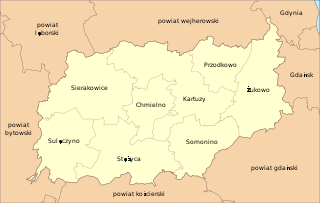
Bernardówka is a village in the administrative district of Gmina Kartuzy, within Kartuzy County, Pomeranian Voivodeship, in northern Poland. It lies approximately 5 kilometres (3 mi) south of Kartuzy and 30 km (19 mi) west of the regional capital Gdańsk.
Bór-Okola is a village in the administrative district of Gmina Kartuzy, within Kartuzy County, Pomeranian Voivodeship, in northern Poland. It lies approximately 6 kilometres (4 mi) south-east of Kartuzy and 26 km (16 mi) west of the regional capital Gdańsk.
Borowo ; Kashubian: Bòrowò is a village in the administrative district of Gmina Kartuzy, within Kartuzy County, Pomeranian Voivodeship, in northern Poland. It lies approximately 6 kilometres (4 mi) east of Kartuzy and 24 km (15 mi) west of the regional capital Gdańsk.
Mezowo is a village in the administrative district of Gmina Kartuzy, within Kartuzy County, Pomeranian Voivodeship, in northern Poland. It lies approximately 5 kilometres (3 mi) south-east of Kartuzy and 27 km (17 mi) west of the regional capital Gdańsk.
Nowinki is a village in the administrative district of Gmina Kartuzy, within Kartuzy County, Pomeranian Voivodeship, in northern Poland. It lies approximately 11 kilometres (7 mi) north-west of Kartuzy and 35 km (22 mi) west of the regional capital Gdańsk.
Pieczyska is a village in the administrative district of Gmina Kartuzy, within Kartuzy County, Pomeranian Voivodeship, in northern Poland. It lies approximately 4 kilometres (2 mi) north of Kartuzy and 28 km (17 mi) west of the regional capital Gdańsk.
Pikarnia is a village in the administrative district of Gmina Kartuzy, within Kartuzy County, Pomeranian Voivodeship, in northern Poland. It lies approximately 6 kilometres (4 mi) south-east of Kartuzy and 24 km (15 mi) west of the regional capital Gdańsk.
Prokowskie Chrósty is a village in the administrative district of Gmina Kartuzy, within Kartuzy County, Pomeranian Voivodeship, in northern Poland. It lies approximately 3 kilometres (2 mi) north of Kartuzy and 29 km (18 mi) west of the regional capital Gdańsk.
Przybród is a village in the administrative district of Gmina Kartuzy, within Kartuzy County, Pomeranian Voivodeship, in northern Poland. It lies approximately 7 kilometres (4 mi) south-west of Kartuzy and 34 km (21 mi) west of the regional capital Gdańsk.
Smętowo Leśne is a village in the administrative district of Gmina Kartuzy, within Kartuzy County, Pomeranian Voivodeship, in northern Poland. It lies approximately 6 kilometres (4 mi) south-west of Kartuzy and 33 km (21 mi) west of the regional capital Gdańsk.
Szotowo is a village in the administrative district of Gmina Kartuzy, within Kartuzy County, Pomeranian Voivodeship, in northern Poland. It lies approximately 5 kilometres (3 mi) south-west of Kartuzy and 33 km (21 mi) west of the regional capital Gdańsk.
Kłosowo is a village in the administrative district of Gmina Przodkowo, within Kartuzy County, Pomeranian Voivodeship, in northern Poland. It lies approximately 5 kilometres (3 mi) north of Przodkowo, 12 km (7 mi) north-east of Kartuzy, and 23 km (14 mi) west of the regional capital Gdańsk.
Smołdzino is a village in the administrative district of Gmina Przodkowo, within Kartuzy County, Pomeranian Voivodeship, in northern Poland. It lies approximately 3 kilometres (2 mi) south of Przodkowo, 8 km (5 mi) east of Kartuzy, and 22 km (14 mi) west of the regional capital Gdańsk.
Bór is a village in the administrative district of Gmina Sierakowice, within Kartuzy County, Pomeranian Voivodeship, in northern Poland. It lies approximately 8 kilometres (5 mi) east of Sierakowice, 13 km (8 mi) west of Kartuzy, and 41 km (25 mi) west of the regional capital Gdańsk.
Jelonko is a village in the administrative district of Gmina Sierakowice, within Kartuzy County, Pomeranian Voivodeship, in northern Poland. It lies approximately 4 kilometres (2 mi) south of Sierakowice, 19 km (12 mi) west of Kartuzy, and 48 km (30 mi) west of the regional capital Gdańsk.
Łączki is a village in the administrative district of Gmina Sierakowice, within Kartuzy County, Pomeranian Voivodeship, in northern Poland. It lies approximately 7 kilometres (4 mi) east of Sierakowice, 14 km (9 mi) west of Kartuzy, and 42 km (26 mi) west of the regional capital Gdańsk.
Leszczynki is a village in the administrative district of Gmina Sierakowice, within Kartuzy County, Pomeranian Voivodeship, in northern Poland. It lies approximately 7 kilometres (4 mi) south-east of Sierakowice, 18 km (11 mi) west of Kartuzy, and 46 km (29 mi) west of the regional capital Gdańsk.
Gołubie-Wybudowanie is a village in the administrative district of Gmina Stężyca, within Kartuzy County, Pomeranian Voivodeship, in northern Poland. It lies approximately 6 kilometres (4 mi) east of Stężyca, 17 km (11 mi) south-west of Kartuzy, and 43 km (27 mi) west of the regional capital Gdańsk.
Liniewko Kościerskie is a village in the administrative district of Gmina Nowa Karczma, within Kościerzyna County, Pomeranian Voivodeship, in northern Poland. It lies approximately 4 kilometres (2 mi) south-west of Nowa Karczma, 13 km (8 mi) east of Kościerzyna, and 42 km (26 mi) south-west of the regional capital Gdańsk.
Nowa Cerkiew is a village in the administrative district of Gmina Ostaszewo, within Nowy Dwór Gdański County, Pomeranian Voivodeship, in northern Poland. It lies approximately 5 kilometres (3 mi) south-west of Ostaszewo, 15 km (9 mi) west of Nowy Dwór Gdański, and 28 km (17 mi) south-east of the regional capital Gdańsk.