
A floodplain or flood plain or bottomlands is an area of land adjacent to a river. Floodplains stretch from the banks of a river channel to the base of the enclosing valley, and experience flooding during periods of high discharge. The soils usually consist of clays, silts, sands, and gravels deposited during floods.
Modimolle, also known as Nylstroom, is a town located near the southern edge of the Waterberg Massif in Limpopo province, South Africa. It is a medium-sized town that focuses primarily on agriculture and farming as well as wildlife and tourism. Nylstroom is also located approximately 135 kilometres north of Pretoria, South Africa's capital city.

The Pantanal is a natural region encompassing the world's largest tropical wetland area, and the world's largest flooded grasslands. It is located mostly within the Brazilian state of Mato Grosso do Sul, but it extends into Mato Grosso and portions of Bolivia and Paraguay. It sprawls over an area estimated at between 140,000 and 195,000 km2. Various subregional ecosystems exist, each with distinct hydrological, geological, and ecological characteristics; up to 12 of them have been defined.

The Bushveld is a sub-tropical woodland ecoregion of Southern Africa. The ecoregion straddles the Tropic of Capricorn and constitutes the southern part of the Zambezian region. It encompasses most of Limpopo and a small part of North West in South Africa, the Central and North-East Districts of Botswana and the Matabeleland South and part of Matabeleland North provinces of Zimbabwe. The Kruger National Park has a number of 'Bushveld' camps, but these are strictly speaking in the lowveld, as these terms are sometimes used interchangeably. Although their limits are somewhat blurred, lowveld is generally restricted to the more easterly parts of South Africa and Zimbabwe.

The Tana River is the longest river in Kenya, it is also called Sagana River in the Mt Kenya region and gives its name to the Tana River County. It's ca. 1000 km long, its catchment covers ca. 100,000 km2 and can be divided into the headwaters and the lower Tana consisting of the section downstream of Kora where the river flows for ca. 700 km through semi-arid plains. Its tributaries include some major rivers in the Central Region like Thika, Ragati River, Nyamindi, Thiba, Mathioya, Chania, Thuci and Mutonga. The river rises from Mt Kenya in Nyeri. It initially runs southwest before turning south around the massif of Mount Kenya and meanders all the way up to the Indian Ocean. A series of hydroelectric dams has been constructed along the river. These include the Masinga Dam, the Kamburu Dam, the Gitaru Dam, the Kindaruma Dam and the Kiambere Dam. en The Masinga Reservoir and the Kiambere Reservoir, created by the Masinga and Kiambere dams respectively, serve a dual purpose: hydro-electric power (HEP) generation and agricultural irrigation. The other three are used exclusively for HEP generation. A 2003 study reported that two-thirds of Kenya's electrical needs were supplied by the series of dams along the Tana River. Many people believe this river has groundwater underneath it, but it doesn't. The electricity is then supplied to the national grid system and distributed countrywide through a series of substations, transformers and cables.

The Mokolo River is a major watercourse in Limpopo Province of South Africa. This river collects much of the drainage of the Waterberg Massif and discharges it to the Limpopo River. The river's catchment area comprises 8,387 square kilometres (3,238 sq mi).

Alma is a small town situated south of Vaalwater in the Limpopo province of South Africa. The area is surrounded by green-gray bushveld vegetation and a several private game reserves are located in the malaria free area.

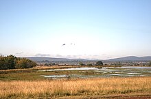
Nylsvley Nature Reserve is a 40 km2 (15 sq mi) protected area, located on and beside the seasonally-inundated floodplain of the Nyl River, the uppermost section of the Mogalakwena which has a very shallow gradient. It is located near Mookgophong in the Limpopo Province of South Africa. The area has been declared a Ramsar wetland site because of its international conservation importance. The floodplain is made up of extensive reedbeds and grassveld surrounded by open woodland.
The Sand River or Polokwane River is a watercourse in Limpopo Province, South Africa, a right hand tributary of the Limpopo River. Its new name "Polokwane River" is homonymous with the name of the town of Polokwane, formerly Pietersburg, about 200 kilometres (120 mi) upriver from its mouth. The Sand River flows by the western edge of this town.

The Marico River or Madikwe is a river in Southern Africa. There are a number of dams in its basin. Groot Marico town is named after the Marico River. After it is joined on its right bank by the Crocodile River it is known as the Limpopo River.
The R101 is a Regional Route in South Africa that is the designation for some of the old sections of roads that were previously the N1, prior to upgrading. It only has 2 sections, from Bellville to Worcester and from Johannesburg to Polokwane.
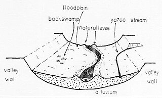
A Yazoo stream is a geologic and hydrologic term for any tributary stream that runs parallel to, and within the floodplain of a larger river for considerable distance, before eventually joining it. This is especially the characteristic when such a stream is forced to flow along the base of the main river's natural levee. Where the two meet is known as a "belated confluence" or a "deferred junction". The name is derived from an exterminated Native American tribe, the Yazoo Indians. The Choctaw word is translated to "River of Death" because of the strong flows under its bank full stage.
The Wembere River is a river located in north western Singida Region, Tanzania. The river is part of the water basin of Lake Eyasi.

The Steelpoort River, iNdubazi or Tubatse is a river in Limpopo Province, South Africa. It flows northeastwards and is a right hand tributary of the Olifants River, joining it at the lower end of its basin. Its source is located at Kwaggaskop, a farm between Dullstroom, Stoffberg and Belfast.

The Mogalakwena River is one of the main watercourses in Limpopo Province, South Africa. It is also a major tributary of the Limpopo River.
The Elands River is a river in the former Transvaal area, South Africa. It is a tributary of the Olifants River, part of the Limpopo River basin.

The Tsiribihina is a river of western Madagascar.
The Springbok Flats is an extensive plain situated in Limpopo, South Africa. The southern boundary is the Pienaars River which intersects the N1 main road between Pretoria and Polokwane. To the west it includes the towns of Bela-Bela, Modimolle, Mookgophong and Mokopane. Towards the east it includes the towns Roedtan, Crecy, Marolong, Nutfield, Tuinplaas and Settlers. The 80 km wide and 130 km long swath of land is orientated in a northeasterly direction and is centered on Roedtan.

The Luha is a river in Ukraine and a right tributary of the Bug. Its source is located near the village of Kolpytiv in the Horokhiv Upland. In its upper reaches, the Luha runs mainly in a western, northwestern direction, and later northwards. In its lower stream, it runs mainly in a northwestern direction and enters the Western Bug on northwestern outskirts of the city of Ustyluh.
Vulnerable waters refer to geographically isolated wetlands (GIWs) and to ephemeral and intermittent streams. Ephemeral and intermittent streams are seasonally flowing and are located in headwater position. They are the outer and smallest stems of hydrological networks. Isolated wetlands are located outside floodplain and show poor surface connection to tributaries or floodplains. Geographically isolated wetlands encompass saturated depressions that are the result of fluvial, aeolian, glacial and/or coastal geomorphological processes. They may be natural landforms or the result of human interventions. Vulnerable waters represent the major proportion of river networks.

